
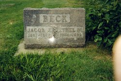

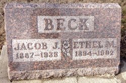
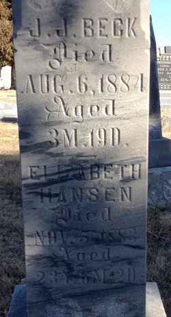
Jacob Jorgensen Beck
| Birth | : | 26 May 1887 Cloud County, Kansas, USA |
| Death | : | 13 Mar 1935 Beloit, Mitchell County, Kansas, USA |
| Burial | : | St. Swithin's Churchyard, Ganarew, Herefordshire Unitary Authority, England |
| Coordinate | : | 51.8433258, -2.6850994 |
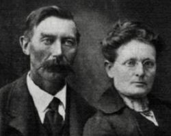
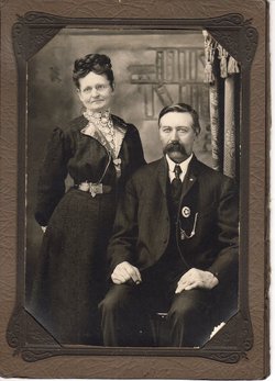
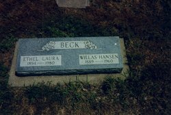
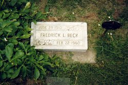
| Description | : | OBITUARY - The Glasco Sun, Glasco, Kansas Jacob Jorgensen Beck, long a resident of Solomon Township, died at Beloit Community Hospital, on March 13, 1935. Jacob was born May 26, 1887 at the home of his parents, Frederick Peterson and Mrs. Margretha Hansen Beck, who were at that time living on their homestead in the south-west corner of the township. He was baptized when an infant into the Lutheran church. He was married in 1907 to Edith Franks, to which union two boys were born. In 1919, he married Ethel Knight, who survives his passing. Besides a period... Read More |
frequently asked questions (FAQ):
-
Where is Jacob Jorgensen Beck's memorial?
Jacob Jorgensen Beck's memorial is located at: St. Swithin's Churchyard, Ganarew, Herefordshire Unitary Authority, England.
-
When did Jacob Jorgensen Beck death?
Jacob Jorgensen Beck death on 13 Mar 1935 in Beloit, Mitchell County, Kansas, USA
-
Where are the coordinates of the Jacob Jorgensen Beck's memorial?
Latitude: 51.8433258
Longitude: -2.6850994
Family Members:
Parent
Spouse
Siblings

Children
Flowers:


Nearby Cemetories:
1. St. Swithin's Churchyard
Ganarew, Herefordshire Unitary Authority, England
Coordinate: 51.8433258, -2.6850994
2. Christ Church Cemetery
Llangarron, Herefordshire Unitary Authority, England
Coordinate: 51.8699460, -2.6889130
3. All Saints Churchyard
Staunton (Coleford), Forest of Dean District, England
Coordinate: 51.8101900, -2.6533900
4. St Mary Churchyard
English Bicknor, Forest of Dean District, England
Coordinate: 51.8390300, -2.6082000
5. Christchurch Churchyard
Coleford, Forest of Dean District, England
Coordinate: 51.8135470, -2.6229980
6. Coleford Cemetery
Coleford, Forest of Dean District, England
Coordinate: 51.7933080, -2.6245110
7. All Saints Churchyard
Newland, Forest of Dean District, England
Coordinate: 51.7825990, -2.6499310
8. All Saints Churchyard
Bishopswood, Herefordshire Unitary Authority, England
Coordinate: 51.8635318, -2.5852627
9. The Parish Church of the Holy Jesus
Lydbrook, Forest of Dean District, England
Coordinate: 51.8376080, -2.5774900
10. St. John the Baptist Churchyard
Ruardean, Forest of Dean District, England
Coordinate: 51.8564500, -2.5515220
11. Clearwell Cemetery Chapel
Clearwell, Forest of Dean District, England
Coordinate: 51.7685400, -2.6167800
12. St Michael churchyard
Garway, Herefordshire Unitary Authority, England
Coordinate: 51.8982110, -2.7934460
13. St Bridget Churchyard
Bridstow, Herefordshire Unitary Authority, England
Coordinate: 51.9204600, -2.6055410
14. St. Dubricius Churchyard
Hentland, Herefordshire Unitary Authority, England
Coordinate: 51.9342080, -2.6660250
15. Forest of Dean Crematorium
Cinderford, Forest of Dean District, England
Coordinate: 51.8098440, -2.5259280
16. Holy Trinity Churchyard
Drybrook, Forest of Dean District, England
Coordinate: 51.8460500, -2.5125400
17. St. Mary the Virgin Churchyard
St Briavels, Forest of Dean District, England
Coordinate: 51.7388290, -2.6405550
18. St. John the Baptist Churchyard
Llanwarne, Herefordshire Unitary Authority, England
Coordinate: 51.9501676, -2.7203512
19. St. Michael and All Angels Churchyard
Brampton Abbots, Herefordshire Unitary Authority, England
Coordinate: 51.9347980, -2.5817590
20. St Paul's Churchyard
Parkend, Forest of Dean District, England
Coordinate: 51.7659090, -2.5521630
21. St John The Evangelist Churchyard
Cinderford, Forest of Dean District, England
Coordinate: 51.8125630, -2.5050510
22. St John The Baptist Churchyard
Kings Caple, Herefordshire Unitary Authority, England
Coordinate: 51.9562740, -2.6433720
23. St. James' Churchyard
Bream, Forest of Dean District, England
Coordinate: 51.7468630, -2.5795910
24. Hoarwithy Church of England
Hentland, Herefordshire Unitary Authority, England
Coordinate: 51.9612740, -2.6625310