
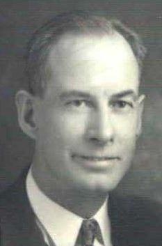

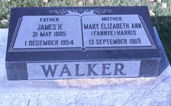
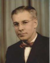
James H Walker
| Birth | : | 31 May 1885 Coalville, Summit County, Utah, USA |
| Death | : | 1 Dec 1954 Raymond, Lethbridge Census Division, Alberta, Canada |
| Burial | : | St Mary the Virgin Churchyard, South Milford, Selby District, England |
| Coordinate | : | 53.7771700, -1.2547300 |
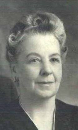
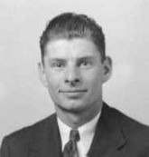
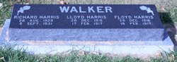
| Description | : | Additional Children: Lloyd Harris Walker: 23 Dec 1916 - 17 Feb. 1917 Floyd Harris Walker: 23 Dec 1916 - 18 Feb 1917 Glen Harris Walker: 4 Nov 1927 - 2008 Source: Glenna Rae Walker White (daughter of Glen Harris Walker). |
frequently asked questions (FAQ):
-
Where is James H Walker's memorial?
James H Walker's memorial is located at: St Mary the Virgin Churchyard, South Milford, Selby District, England.
-
When did James H Walker death?
James H Walker death on 1 Dec 1954 in Raymond, Lethbridge Census Division, Alberta, Canada
-
Where are the coordinates of the James H Walker's memorial?
Latitude: 53.7771700
Longitude: -1.2547300
Family Members:
Parent
Spouse
Siblings
Children

Flowers:


Nearby Cemetories:
1. St Mary the Virgin Churchyard
South Milford, Selby District, England
Coordinate: 53.7771700, -1.2547300
2. All Saints Churchyard
Sherburn-in-Elmet, Selby District, England
Coordinate: 53.7956000, -1.2605740
3. St Wilfrid’s Churchyard
Monk Fryston, Selby District, England
Coordinate: 53.7618300, -1.2349700
4. Monk Fryston Cemetery
Monk Fryston, Selby District, England
Coordinate: 53.7604400, -1.2291700
5. All Saints Churchyard
Ledsham, Metropolitan Borough of Leeds, England
Coordinate: 53.7622160, -1.3091920
6. St James Churchyard
Fairburn, Selby District, England
Coordinate: 53.7426700, -1.2841000
7. Holy Trinity Churchyard
Barkston Ash, Selby District, England
Coordinate: 53.8189530, -1.2547620
8. St. Mary the Virgin Churchyard
Micklefield, Metropolitan Borough of Leeds, England
Coordinate: 53.7971300, -1.3313700
9. Brotherton United Reformed Church
Brotherton, Selby District, England
Coordinate: 53.7277104, -1.2698131
10. All Saints Churchyard
Saxton, Selby District, England
Coordinate: 53.8261760, -1.2787060
11. St Mary the Virgin Churchyard
Church Fenton, Selby District, England
Coordinate: 53.8243100, -1.2203500
12. St Edward the Confessor Churchyard
Brotherton, Selby District, England
Coordinate: 53.7259200, -1.2709600
13. Hambleton Cemetery
Hambleton, Selby District, England
Coordinate: 53.7715910, -1.1624600
14. St Mary Churchyard
Hambleton, Selby District, England
Coordinate: 53.7715910, -1.1624600
15. St. Peter's Churchyard
Fryston, Metropolitan Borough of Wakefield, England
Coordinate: 53.7355400, -1.3151100
16. St Mary Churchyard
Birkin, Selby District, England
Coordinate: 53.7325000, -1.1979000
17. Lotherton Hall Chapel
Leeds, Metropolitan Borough of Leeds, England
Coordinate: 53.8186380, -1.3189740
18. St. Andrew's Old Churchyard
Ferrybridge, Metropolitan Borough of Wakefield, England
Coordinate: 53.7193380, -1.2748540
19. St. Botolph Churchyard
Knottingley, Metropolitan Borough of Wakefield, England
Coordinate: 53.7108080, -1.2441680
20. United Reformed Churchyard
Knottingley, Metropolitan Borough of Wakefield, England
Coordinate: 53.7104820, -1.2397270
21. St Mary the Virgin Churchyard
Kippax, Metropolitan Borough of Leeds, England
Coordinate: 53.7676520, -1.3686680
22. Ropewalk Methodist Church Burial Ground
Knottingley, Metropolitan Borough of Wakefield, England
Coordinate: 53.7092850, -1.2408320
23. Ferrybridge Cemetery
Ferrybridge, Metropolitan Borough of Wakefield, England
Coordinate: 53.7102530, -1.2795200
24. Castleford New Extension Cemetery
Castleford, Metropolitan Borough of Wakefield, England
Coordinate: 53.7277600, -1.3391000