
Janet McLeoud McVean
| Birth | : | 1836 Quebec, Canada |
| Death | : | 1 Apr 1899 |
| Burial | : | Porlock Cemetery, Porlock, West Somerset District, England |
| Coordinate | : | 51.2033790, -3.5954070 |
| Plot | : | 113 |
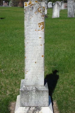
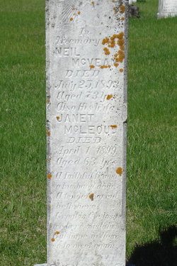
| Description | : | Janet was born about 1836 in St. Patrick, Lower Canada (Quebec). She was the wife of Neil McVean. Janet died at North Sherbrooke Township, Lanark County, Ontario, on April 1,1899, from heart failure. She was living on the west half of lot 8, con 1, of North Sherbrooke. ------------------------------------ Plot 113 : (side 1 of stone) - In memory of, - Neil McVean, died July 25,1893, aged 73 yrs. - also his wife, Janet McLeoud, died April 1,1899, aged 63 yrs. (side 2 of stone) - In memory of, - Catherine Morrison, died Aug.25,1884, aged 77 yrs. - also Isabella McVean, died Sept.3,1877, aged 24 yrs. - also John McVean, died... Read More |
frequently asked questions (FAQ):
-
Where is Janet McLeoud McVean's memorial?
Janet McLeoud McVean's memorial is located at: Porlock Cemetery, Porlock, West Somerset District, England.
-
When did Janet McLeoud McVean death?
Janet McLeoud McVean death on 1 Apr 1899 in
-
Where are the coordinates of the Janet McLeoud McVean's memorial?
Latitude: 51.2033790
Longitude: -3.5954070
Family Members:
Spouse

Children

Flowers:


Nearby Cemetories:
1. Porlock Cemetery
Porlock, West Somerset District, England
Coordinate: 51.2033790, -3.5954070
2. St Dubricius Churchyard
Porlock, West Somerset District, England
Coordinate: 51.2083000, -3.5955000
3. Stoke Pero Churchyard
Porlock, West Somerset District, England
Coordinate: 51.1796510, -3.6060674
4. Luccombe Extension Cemetery
Luccombe, West Somerset District, England
Coordinate: 51.1897360, -3.5609100
5. St. Mary's Churchyard
Luccombe, West Somerset District, England
Coordinate: 51.1895770, -3.5596880
6. Selworthy Extension Cemeteries
Selworthy, West Somerset District, England
Coordinate: 51.2098330, -3.5481240
7. All Saints Churchyard
Selworthy, West Somerset District, England
Coordinate: 51.2101800, -3.5475440
8. Culbone St. Bueno's Churchyard
Oare, West Somerset District, England
Coordinate: 51.2213640, -3.6594820
9. All Saints Churchyard
Wootton Courtenay, West Somerset District, England
Coordinate: 51.1801840, -3.5203550
10. Minehead Cemetery
Minehead, West Somerset District, England
Coordinate: 51.2050650, -3.4982030
11. St. Michael's Anglican Church Cemetery
Minehead, West Somerset District, England
Coordinate: 51.2110390, -3.4808250
12. St. Petrock's Churchyard
Timberscombe, West Somerset District, England
Coordinate: 51.1680950, -3.4948210
13. St. Mary Magdalene Churchyard
Exford, West Somerset District, England
Coordinate: 51.1341450, -3.6342160
14. St. John the Evangelist Churchyard
Cutcombe, West Somerset District, England
Coordinate: 51.1424576, -3.5295319
15. St. Mary the Virgin Churchyard
Oare, West Somerset District, England
Coordinate: 51.2124350, -3.7164290
16. Grabbist Hill Cemetery
Dunster, West Somerset District, England
Coordinate: 51.1820510, -3.4492540
17. George Street Cemetery
Dunster, West Somerset District, England
Coordinate: 51.1833740, -3.4483046
18. Priory Churchyard of St. George
Dunster, West Somerset District, England
Coordinate: 51.1832000, -3.4459000
19. Winsford Churchyard
Winsford, West Somerset District, England
Coordinate: 51.1038000, -3.5665000
20. Saint Andrew's Churchyard
Withypool, West Somerset District, England
Coordinate: 51.1078060, -3.6492700
21. Blesssed Virgin Mary Churchyard
Luxborough, West Somerset District, England
Coordinate: 51.1321490, -3.4680500
22. Saint John the Baptist Churchyard
Carhampton, West Somerset District, England
Coordinate: 51.1746000, -3.4186000
23. St.Luke's Churchyard
Simonsbath, West Somerset District, England
Coordinate: 51.1408600, -3.7514560
24. St Peter's Church Exton
Exton, West Somerset District, England
Coordinate: 51.0925840, -3.5352300