
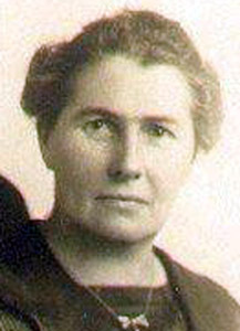
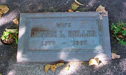
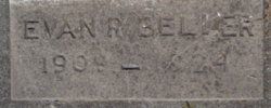
Jennie Louella Tubbs Beller
| Birth | : | 28 Dec 1873 Lemont, Cook County, Illinois, USA |
| Death | : | 7 Jan 1938 Montana, USA |
| Burial | : | Thornbury Cemetery, Thornbury, South Gloucestershire Unitary Authority, England |
| Coordinate | : | 51.6099460, -2.5323000 |
| Description | : | Married Robert Rufus Beller on 23 Mar 1890. To this union, eight children were born. |
frequently asked questions (FAQ):
-
Where is Jennie Louella Tubbs Beller's memorial?
Jennie Louella Tubbs Beller's memorial is located at: Thornbury Cemetery, Thornbury, South Gloucestershire Unitary Authority, England.
-
When did Jennie Louella Tubbs Beller death?
Jennie Louella Tubbs Beller death on 7 Jan 1938 in Montana, USA
-
Where are the coordinates of the Jennie Louella Tubbs Beller's memorial?
Latitude: 51.6099460
Longitude: -2.5323000
Family Members:
Parent
Spouse

Siblings

Children
Flowers:


Nearby Cemetories:
1. Thornbury Cemetery
Thornbury, South Gloucestershire Unitary Authority, England
Coordinate: 51.6099460, -2.5323000
2. St Mary the Virgin Parish Churchyard
Thornbury, South Gloucestershire Unitary Authority, England
Coordinate: 51.6132330, -2.5300090
3. St Helen Churchyard
Alveston, South Gloucestershire Unitary Authority, England
Coordinate: 51.5850600, -2.5303380
4. St Oswald Churchyard
Rockhampton, South Gloucestershire Unitary Authority, England
Coordinate: 51.6374200, -2.5003500
5. St James Parish Churchyard
Tytherington, South Gloucestershire Unitary Authority, England
Coordinate: 51.5932110, -2.4799250
6. St. Mary the Virgin Churchyard
Olveston, South Gloucestershire Unitary Authority, England
Coordinate: 51.5828740, -2.5774290
7. Memorial Woodland Cemetery
Bristol Unitary Authority, England
Coordinate: 51.5754490, -2.5013060
8. Bristol Memorial Woodlands
Alveston, South Gloucestershire Unitary Authority, England
Coordinate: 51.5725340, -2.4983540
9. Mount Pleasant Chapel
Wotton-under-Edge, Stroud District, England
Coordinate: 51.6331000, -2.4610000
10. St Andrew Churchyard
Cromhall, South Gloucestershire Unitary Authority, England
Coordinate: 51.6121930, -2.4456930
11. St. John's Churchyard
Aust, South Gloucestershire Unitary Authority, England
Coordinate: 51.5991080, -2.6186160
12. Almondsbury Cemetery
Almondsbury, South Gloucestershire Unitary Authority, England
Coordinate: 51.5588230, -2.5760360
13. Almondsbury Cemetery
Bristol Unitary Authority, England
Coordinate: 51.5589695, -2.5768189
14. Church of the Holy Trinity
Rangeworthy, South Gloucestershire Unitary Authority, England
Coordinate: 51.5742000, -2.4536000
15. St Mary's Churchyard
Almondsbury, South Gloucestershire Unitary Authority, England
Coordinate: 51.5542300, -2.5733390
16. All Saints Churchyard
Stone, Stroud District, England
Coordinate: 51.6566800, -2.4575600
17. Mayshill Cemetery
South Gloucestershire Unitary Authority, England
Coordinate: 51.5562160, -2.4691663
18. St Leonard Churchyard
Tortworth, Stroud District, England
Coordinate: 51.6379440, -2.4286650
19. St. John the Evangelist Churchyard
Beachley, Forest of Dean District, England
Coordinate: 51.6184750, -2.6505640
20. Beachley Barracks Military Cemetery
Beachley, Forest of Dean District, England
Coordinate: 51.6185000, -2.6512000
21. St James the Less Churchyard
Iron Acton, South Gloucestershire Unitary Authority, England
Coordinate: 51.5490390, -2.4619310
22. St Peter's Churchyard
Frampton Cotterell, South Gloucestershire Unitary Authority, England
Coordinate: 51.5359115, -2.4801320
23. Holy Trinity Churchyard
Wickwar, South Gloucestershire Unitary Authority, England
Coordinate: 51.5985120, -2.4006930
24. St. Michael the Archangel Churchyard
Winterbourne, South Gloucestershire Unitary Authority, England
Coordinate: 51.5269000, -2.5183600