
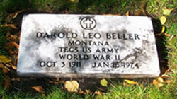
Leo Darold Beller
| Birth | : | 3 Oct 1911 Wetaskiwin, Edmonton Census Division, Alberta, Canada |
| Death | : | 16 Jan 1974 Whitefish, Flathead County, Montana, USA |
| Burial | : | Thornbury Cemetery, Thornbury, South Gloucestershire Unitary Authority, England |
| Coordinate | : | 51.6099460, -2.5323000 |
| Description | : | Leo Darold Beller, 62, died in Whitefish Wednesday evening. He was born Oct. 3, 1911, in Wetaskwin [sic], Alberta, Canada, a son of Robert and Jennie Beller. In 1914, he moved with his parents to Whitefish where he attended Whitefish schools. He then entered the carpentry trade for a time and in 1940 was employed in the bridge and builders department for the Great Northern Railway. He entered the U.S. Army where he served during World War II, returning to Whitefish where he continued to work for the railroad until 1951. He was then associated with his... Read More |
frequently asked questions (FAQ):
-
Where is Leo Darold Beller's memorial?
Leo Darold Beller's memorial is located at: Thornbury Cemetery, Thornbury, South Gloucestershire Unitary Authority, England.
-
When did Leo Darold Beller death?
Leo Darold Beller death on 16 Jan 1974 in Whitefish, Flathead County, Montana, USA
-
Where are the coordinates of the Leo Darold Beller's memorial?
Latitude: 51.6099460
Longitude: -2.5323000
Family Members:
Parent

Spouse
Siblings
Children

Flowers:


Nearby Cemetories:
1. Thornbury Cemetery
Thornbury, South Gloucestershire Unitary Authority, England
Coordinate: 51.6099460, -2.5323000
2. St Mary the Virgin Parish Churchyard
Thornbury, South Gloucestershire Unitary Authority, England
Coordinate: 51.6132330, -2.5300090
3. St Helen Churchyard
Alveston, South Gloucestershire Unitary Authority, England
Coordinate: 51.5850600, -2.5303380
4. St Oswald Churchyard
Rockhampton, South Gloucestershire Unitary Authority, England
Coordinate: 51.6374200, -2.5003500
5. St James Parish Churchyard
Tytherington, South Gloucestershire Unitary Authority, England
Coordinate: 51.5932110, -2.4799250
6. St. Mary the Virgin Churchyard
Olveston, South Gloucestershire Unitary Authority, England
Coordinate: 51.5828740, -2.5774290
7. Memorial Woodland Cemetery
Bristol Unitary Authority, England
Coordinate: 51.5754490, -2.5013060
8. Bristol Memorial Woodlands
Alveston, South Gloucestershire Unitary Authority, England
Coordinate: 51.5725340, -2.4983540
9. Mount Pleasant Chapel
Wotton-under-Edge, Stroud District, England
Coordinate: 51.6331000, -2.4610000
10. St Andrew Churchyard
Cromhall, South Gloucestershire Unitary Authority, England
Coordinate: 51.6121930, -2.4456930
11. St. John's Churchyard
Aust, South Gloucestershire Unitary Authority, England
Coordinate: 51.5991080, -2.6186160
12. Almondsbury Cemetery
Almondsbury, South Gloucestershire Unitary Authority, England
Coordinate: 51.5588230, -2.5760360
13. Almondsbury Cemetery
Bristol Unitary Authority, England
Coordinate: 51.5589695, -2.5768189
14. Church of the Holy Trinity
Rangeworthy, South Gloucestershire Unitary Authority, England
Coordinate: 51.5742000, -2.4536000
15. St Mary's Churchyard
Almondsbury, South Gloucestershire Unitary Authority, England
Coordinate: 51.5542300, -2.5733390
16. All Saints Churchyard
Stone, Stroud District, England
Coordinate: 51.6566800, -2.4575600
17. Mayshill Cemetery
South Gloucestershire Unitary Authority, England
Coordinate: 51.5562160, -2.4691663
18. St Leonard Churchyard
Tortworth, Stroud District, England
Coordinate: 51.6379440, -2.4286650
19. St. John the Evangelist Churchyard
Beachley, Forest of Dean District, England
Coordinate: 51.6184750, -2.6505640
20. Beachley Barracks Military Cemetery
Beachley, Forest of Dean District, England
Coordinate: 51.6185000, -2.6512000
21. St James the Less Churchyard
Iron Acton, South Gloucestershire Unitary Authority, England
Coordinate: 51.5490390, -2.4619310
22. St Peter's Churchyard
Frampton Cotterell, South Gloucestershire Unitary Authority, England
Coordinate: 51.5359115, -2.4801320
23. Holy Trinity Churchyard
Wickwar, South Gloucestershire Unitary Authority, England
Coordinate: 51.5985120, -2.4006930
24. St. Michael the Archangel Churchyard
Winterbourne, South Gloucestershire Unitary Authority, England
Coordinate: 51.5269000, -2.5183600