
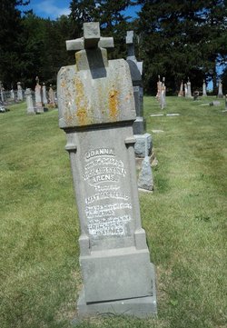
Johanna Arens Herrig
| Birth | : | 18 Sep 1843 Olm, Canton de Capellen, Luxembourg, Luxembourg |
| Death | : | 5 Aug 1865 Saint Donatus, Jackson County, Iowa, USA |
| Burial | : | St. Nicholas's Churchyard, Stanford-on-Avon, Daventry District, England |
| Coordinate | : | 52.4045020, -1.1359770 |
frequently asked questions (FAQ):
-
Where is Johanna Arens Herrig's memorial?
Johanna Arens Herrig's memorial is located at: St. Nicholas's Churchyard, Stanford-on-Avon, Daventry District, England.
-
When did Johanna Arens Herrig death?
Johanna Arens Herrig death on 5 Aug 1865 in Saint Donatus, Jackson County, Iowa, USA
-
Where are the coordinates of the Johanna Arens Herrig's memorial?
Latitude: 52.4045020
Longitude: -1.1359770
Family Members:
Parent

Spouse
Siblings
Children
Flowers:


Nearby Cemetories:
1. St. Nicholas's Churchyard
Stanford-on-Avon, Daventry District, England
Coordinate: 52.4045020, -1.1359770
2. St Nicholas' Churchyard
Stanford on Avon, Harborough District, England
Coordinate: 52.4045560, -1.1362100
3. St. Andrew's Churchyard
Clay Coton, Daventry District, England
Coordinate: 52.3871456, -1.1290185
4. All Saints Churchyard
Swinford, Harborough District, England
Coordinate: 52.4099260, -1.1642830
5. Greenhaven Woodland Burial Ground
Lilbourne, Daventry District, England
Coordinate: 52.3881390, -1.1545970
6. Swinford cemetery
Swinford, Harborough District, England
Coordinate: 52.4088297, -1.1695096
7. All Saints Churchyard
Lilbourne, Daventry District, England
Coordinate: 52.3919370, -1.1778810
8. St Nicholas Church
South Kilworth, Harborough District, England
Coordinate: 52.4316750, -1.1125110
9. Lilbourne Burial Ground
Lilbourne, Daventry District, England
Coordinate: 52.3885400, -1.1792400
10. Yelvertoft Independent Chapel Churchyard
Yelvertoft, Daventry District, England
Coordinate: 52.3736980, -1.1225680
11. St. Thomas Churchyard, Catthorpe
Catthorpe, Harborough District, England
Coordinate: 52.3986350, -1.1900710
12. All Saints Churchyard
Yelvertoft, Daventry District, England
Coordinate: 52.3717866, -1.1164310
13. Yelvertoft Cemetery
Yelvertoft, Daventry District, England
Coordinate: 52.3707000, -1.1153400
14. All Saints Churchyard
Shawell, Harborough District, England
Coordinate: 52.4123910, -1.2055290
15. St. Andrew Churchyard
North Kilworth, Harborough District, England
Coordinate: 52.4432190, -1.0950880
16. St. Mary's Churchyard Extension
Welford, Daventry District, England
Coordinate: 52.4173836, -1.0595687
17. St Mary the Virgin Churchyard
Welford, Daventry District, England
Coordinate: 52.4172618, -1.0587465
18. St Leonard Churchyard
Misterton, Harborough District, England
Coordinate: 52.4510630, -1.1818140
19. Clifton-Upon-Dunsmore Cemetery
Clifton upon Dunsmore, Rugby Borough, England
Coordinate: 52.3857800, -1.2197400
20. St Mary's Churchyard
Cotesbach, Harborough District, England
Coordinate: 52.4371220, -1.2085910
21. St. Mary's Churchyard
Clifton upon Dunsmore, Rugby Borough, England
Coordinate: 52.3830220, -1.2208600
22. St. Michael and All Angels Churchyard
Winwick, Daventry District, England
Coordinate: 52.3589063, -1.0820887
23. St. Margaret Churchyard
Crick, Daventry District, England
Coordinate: 52.3476230, -1.1378110
24. Crick United Reformed Churchyard
Crick, Daventry District, England
Coordinate: 52.3469872, -1.1339944