

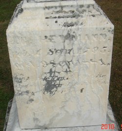
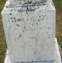
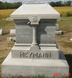
John Philip Heymann
| Birth | : | 9 Jul 1833 Kaltenholzhausen, Rhein-Lahn-Kreis, Rheinland-Pfalz, Germany |
| Death | : | 21 Nov 1899 Huron County, Ohio, USA |
| Burial | : | Haycombe Cemetery and Crematorium, Bath, Bath and North East Somerset Unitary Authority, England |
| Coordinate | : | 51.3703430, -2.4014760 |
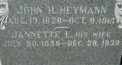
| Description | : | John Philip was the seventh child of Johann George and Maria Margareta Heymann. He attended school in the village of Kaltenholzhausen. At age 15, he emigrated with his family to Hunt's Corners, Huron Co., Ohio. John Philip married Johannette (Jennette) Scheid on April 17, 1856. They lived in the vicinity of Hunt's Corners and bought a 102 acre parcel in Lyme Twp. from his father. He and Jennette were parents to nine children. One year, they suffered the misfortune of having their house burn on Christmas Eve. It was eventually rebuilt, but in 1873, they moved to the Wood homestead north of... Read More |
frequently asked questions (FAQ):
-
Where is John Philip Heymann's memorial?
John Philip Heymann's memorial is located at: Haycombe Cemetery and Crematorium, Bath, Bath and North East Somerset Unitary Authority, England.
-
When did John Philip Heymann death?
John Philip Heymann death on 21 Nov 1899 in Huron County, Ohio, USA
-
Where are the coordinates of the John Philip Heymann's memorial?
Latitude: 51.3703430
Longitude: -2.4014760
Family Members:
Parent
Spouse
Siblings

Children
Flowers:


Nearby Cemetories:
1. Haycombe Cemetery and Crematorium
Bath, Bath and North East Somerset Unitary Authority, England
Coordinate: 51.3703430, -2.4014760
2. St Peter Churchyard
Englishcombe, Bath and North East Somerset Unitary Authority, England
Coordinate: 51.3640600, -2.4088700
3. St Michael and All Angels Churchyard
Twerton, Bath and North East Somerset Unitary Authority, England
Coordinate: 51.3809000, -2.3981000
4. Twerton Cemetery
Twerton, Bath and North East Somerset Unitary Authority, England
Coordinate: 51.3802500, -2.3836220
5. Locksbrook Cemetery
Lower Weston, Bath and North East Somerset Unitary Authority, England
Coordinate: 51.3845180, -2.3850300
6. Locksbrook St Saviour's Cemetery
Bath and North East Somerset Unitary Authority, England
Coordinate: 51.3867880, -2.3863380
7. St. Michael's Cemetery
Bath, Bath and North East Somerset Unitary Authority, England
Coordinate: 51.3859700, -2.3814500
8. Bath Union Workhouse Burial Ground
Bath, Bath and North East Somerset Unitary Authority, England
Coordinate: 51.3570889, -2.3773370
9. St. James' Cemetery
Bath, Bath and North East Somerset Unitary Authority, England
Coordinate: 51.3802000, -2.3722200
10. Holy Trinity Churchyard
Newton St Loe, Bath and North East Somerset Unitary Authority, England
Coordinate: 51.3820470, -2.4311300
11. Bath Union Workhouse Graveyard
Bath, Bath and North East Somerset Unitary Authority, England
Coordinate: 51.3584160, -2.3711140
12. Moravian Burial Ground
Bath, Bath and North East Somerset Unitary Authority, England
Coordinate: 51.3894150, -2.3798150
13. St Mary Magdalen Chapel
Widcombe, Bath and North East Somerset Unitary Authority, England
Coordinate: 51.3760486, -2.3643405
14. St Mary's Chapel, Queens Square
Bath, Bath and North East Somerset Unitary Authority, England
Coordinate: 51.3827790, -2.3649790
15. All Saints Churchyard
Weston, Bath and North East Somerset Unitary Authority, England
Coordinate: 51.3956850, -2.3881320
16. St James Old Burial Ground
Bath, Bath and North East Somerset Unitary Authority, England
Coordinate: 51.3798600, -2.3610100
17. Countess of Huntingdon's Chapel
Walcot, Bath and North East Somerset Unitary Authority, England
Coordinate: 51.3967020, -2.3907434
18. Saint Mark's Churchyard
Widcombe, Bath and North East Somerset Unitary Authority, England
Coordinate: 51.3766660, -2.3588010
19. Bath General Hospital Burial Ground
Bath and North East Somerset Unitary Authority, England
Coordinate: 51.3824715, -2.3614742
20. St. Mary de Stall Churchyard (Defunct)
Bath, Bath and North East Somerset Unitary Authority, England
Coordinate: 51.3813350, -2.3600353
21. Quaker Meeting House
Bath, Bath and North East Somerset Unitary Authority, England
Coordinate: 51.3823280, -2.3604380
22. All Saints Churchyard
Corston, Bath and North East Somerset Unitary Authority, England
Coordinate: 51.3857350, -2.4400372
23. Old Orchard Street Catholic Burial Vault
Bath, Bath and North East Somerset Unitary Authority, England
Coordinate: 51.3800370, -2.3579910
24. Bath Abbey
Bath, Bath and North East Somerset Unitary Authority, England
Coordinate: 51.3815310, -2.3586640