
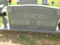
Johnnie Lee Helms
| Birth | : | 29 Aug 1926 Union County, North Carolina, USA |
| Death | : | 22 Jan 2009 Union County, North Carolina, USA |
| Burial | : | Georgia Slide Cemetery, Georgetown, El Dorado County, USA |
| Coordinate | : | 38.9218063, -120.8377838 |
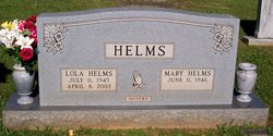
| Description | : | MONROE Johnnie Lee Helms, 82, died Thursday (Jan. 22, 2009) at Carolinas Medical Center-Union. Born Aug. 29, 1926, in Union County, she was a daughter of the late Johnny and Lola High Helms. Survivors include two sisters, Mrs. Cecil Ray Paxton, Mary F. Helms, both of Monroe; two brothers, M.T. Helms of Manning, S.C., Joe Neal Helms of Monroe. Funeral will be 2 p.m. Saturday at the home, with burial in the New Salem Baptist Church cemetery. |
frequently asked questions (FAQ):
-
Where is Johnnie Lee Helms's memorial?
Johnnie Lee Helms's memorial is located at: Georgia Slide Cemetery, Georgetown, El Dorado County, USA.
-
When did Johnnie Lee Helms death?
Johnnie Lee Helms death on 22 Jan 2009 in Union County, North Carolina, USA
-
Where are the coordinates of the Johnnie Lee Helms's memorial?
Latitude: 38.9218063
Longitude: -120.8377838
Family Members:
Parent

Siblings


Flowers:


Nearby Cemetories:
1. Georgia Slide Cemetery
Georgetown, El Dorado County, USA
Coordinate: 38.9218063, -120.8377838
2. Georgetown Pioneer Cemetery
Georgetown, El Dorado County, USA
Coordinate: 38.9068108, -120.8430862
3. Carmelite Monastery Cemetery
Georgetown, El Dorado County, USA
Coordinate: 38.9273300, -120.8173840
4. Greenwood Pioneer Cemetery
Greenwood, El Dorado County, USA
Coordinate: 38.8985786, -120.9099274
5. Georgetown-Renke Cemetery Annex
Georgetown, El Dorado County, USA
Coordinate: 38.8964610, -120.9116240
6. Spanish Dry Diggings Cemetery
Greenwood, El Dorado County, USA
Coordinate: 38.9431600, -120.9158000
7. Josephine Mine Cemetery
Volcanoville, El Dorado County, USA
Coordinate: 38.9798000, -120.7892170
8. Todd Valley Cemetery
Placer County, USA
Coordinate: 38.9970900, -120.8541000
9. Alabama Flat Cemetery
Garden Valley, El Dorado County, USA
Coordinate: 38.8413660, -120.8770510
10. Spring Garden Indian Cemetery
Foresthill, Placer County, USA
Coordinate: 38.9998620, -120.9049310
11. Foresthill Community Cemetery
Foresthill, Placer County, USA
Coordinate: 39.0184500, -120.8114700
12. Saint Joseph Catholic Cemetery
Foresthill, Placer County, USA
Coordinate: 39.0240200, -120.8068800
13. Yankee Jims Cemetery
Foresthill, Placer County, USA
Coordinate: 39.0292511, -120.8614349
14. Stoney Bar Cemetery
Foresthill, Placer County, USA
Coordinate: 39.0114980, -120.7408060
15. Esoteric Fraternity Cemetery
Applegate, Placer County, USA
Coordinate: 38.9946190, -120.9687490
16. Kelsey Cemetery
Kelsey, El Dorado County, USA
Coordinate: 38.7949791, -120.8200073
17. Saint John's Catholic Churchyard
Coloma, El Dorado County, USA
Coordinate: 38.7975311, -120.8919678
18. James Marshall Monument and Gravesite
Coloma, El Dorado County, USA
Coordinate: 38.7963104, -120.8953781
19. Pioneer Cemetery
Coloma, El Dorado County, USA
Coordinate: 38.7943192, -120.8894577
20. Uniontown Cemetery
Lotus, El Dorado County, USA
Coordinate: 38.7994003, -120.9111023
21. Indian Creek Cemetery
Coloma, El Dorado County, USA
Coordinate: 38.7974230, -120.9104530
22. Michigan Bluff Cemetery
Placer County, USA
Coordinate: 39.0409400, -120.7401200
23. Deadwood Cemetery
Foresthill, Placer County, USA
Coordinate: 39.0447700, -120.7361200
24. Odd Fellows Cemetery
Michigan Bluff, Placer County, USA
Coordinate: 39.0449240, -120.7361840