
José Manuel Higuera
| Birth | : | 1744 Sinaloa de Leyva, Sinaloa Municipality, Sinaloa, Mexico |
| Death | : | 29 Aug 1828 San Juan Bautista, San Benito County, California, USA |
| Burial | : | Mission San Juan Bautista Cemetery, San Juan Bautista, San Benito County, USA |
| Coordinate | : | 36.8460007, -121.5339966 |
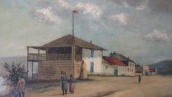
| Description | : | Manuel was one of twelve soldiers traveling with their families with the second Rivera expedition, from San Blas to Loreto, then overland by way of the Baja California missions to San Diego, San Gabriel and Monterey, arriving September 1774. The intention was to relieve soldiers from the earlier "Sacred Expedition", and they were among the earliest settlers in Monterey, La Misión de San Carlos Borromeo de Monterey. Established with only thatch roofed huts in 1770, a square later secured in stone for the presidio as well, La Capilla Real del Presidio de Monterey, the Royal Presidio Chapel, still stands as... Read More |
frequently asked questions (FAQ):
-
Where is José Manuel Higuera's memorial?
José Manuel Higuera's memorial is located at: Mission San Juan Bautista Cemetery, San Juan Bautista, San Benito County, USA.
-
When did José Manuel Higuera death?
José Manuel Higuera death on 29 Aug 1828 in San Juan Bautista, San Benito County, California, USA
-
Where are the coordinates of the José Manuel Higuera's memorial?
Latitude: 36.8460007
Longitude: -121.5339966
Family Members:
Spouse
Children

Flowers:


Nearby Cemetories:
1. Mission San Juan Bautista Cemetery
San Juan Bautista, San Benito County, USA
Coordinate: 36.8460007, -121.5339966
2. San Juan Bautista Cemetery
San Juan Bautista, San Benito County, USA
Coordinate: 36.8457985, -121.5438995
3. Odd Fellows Cemetery
Hollister, San Benito County, USA
Coordinate: 36.8571210, -121.4104100
4. Hambey Cemetery
Monterey County, USA
Coordinate: 36.8372002, -121.6793976
5. Monterey Bay Loved Pet Cemetery
Monterey County, USA
Coordinate: 36.8326160, -121.6812820
6. Calvary-Sacred Heart Cemetery
Hollister, San Benito County, USA
Coordinate: 36.8483009, -121.3767014
7. Queen of Heaven Cemetery
Prunedale, Monterey County, USA
Coordinate: 36.7602425, -121.6611252
8. Saint Benedicts Columbarium
Hollister, San Benito County, USA
Coordinate: 36.8337440, -121.3667120
9. Santa Rita Chapel and Cemetery
Salinas, Monterey County, USA
Coordinate: 36.7281303, -121.6565475
10. Saint Georges Episcopal Church Columbarium
Salinas, Monterey County, USA
Coordinate: 36.7062580, -121.6440980
11. Monterey County Potters Field Cemetery
Salinas, Monterey County, USA
Coordinate: 36.6960900, -121.6381950
12. Gavilan Hills Memorial Park
Gilroy, Santa Clara County, USA
Coordinate: 37.0124000, -121.5909200
13. Chinese Cemetery
Salinas, Monterey County, USA
Coordinate: 36.6952057, -121.6390381
14. Saint Mary Cemetery
Gilroy, Santa Clara County, USA
Coordinate: 37.0134300, -121.5882000
15. Saint Mary Church Cemetery
Gilroy, Santa Clara County, USA
Coordinate: 37.0155970, -121.5765950
16. Stephen Norriss Gravesite
Monterey County, USA
Coordinate: 36.8214110, -121.7601080
17. All Saints Episcopal Church Memorial Garden
Watsonville, Santa Cruz County, USA
Coordinate: 36.9102310, -121.7568950
18. Pajaro Valley Memorial Park
Watsonville, Santa Cruz County, USA
Coordinate: 36.9629669, -121.7219391
19. Valley Public Cemetery
Watsonville, Santa Cruz County, USA
Coordinate: 36.9418983, -121.7400513
20. Valley Catholic Cemetery
Watsonville, Santa Cruz County, USA
Coordinate: 36.9415932, -121.7405777
21. Calvary Catholic Cemetery
Salinas, Monterey County, USA
Coordinate: 36.6880341, -121.6818085
22. Pioneer Cemetery
Watsonville, Santa Cruz County, USA
Coordinate: 36.9258560, -121.7642790
23. Watsonville Catholic Cemetery
Watsonville, Santa Cruz County, USA
Coordinate: 36.9278564, -121.7658463
24. Yamato Cemetery
Salinas, Monterey County, USA
Coordinate: 36.6552811, -121.6307297