
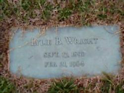
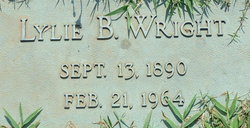
Lylie Ethel Buzhardt Wright
| Birth | : | 13 Sep 1890 USA |
| Death | : | 21 Feb 1964 USA |
| Burial | : | St Mary the Virgin Churchyard, Therfield, North Hertfordshire District, England |
| Coordinate | : | 52.0162060, -0.0568230 |
| Description | : | Wife of Fletcher T. Wtight.Buried beside him. |
frequently asked questions (FAQ):
-
Where is Lylie Ethel Buzhardt Wright's memorial?
Lylie Ethel Buzhardt Wright's memorial is located at: St Mary the Virgin Churchyard, Therfield, North Hertfordshire District, England.
-
When did Lylie Ethel Buzhardt Wright death?
Lylie Ethel Buzhardt Wright death on 21 Feb 1964 in USA
-
Where are the coordinates of the Lylie Ethel Buzhardt Wright's memorial?
Latitude: 52.0162060
Longitude: -0.0568230
Family Members:
Parent
Spouse
Children
Flowers:


Nearby Cemetories:
1. St Mary the Virgin Churchyard
Therfield, North Hertfordshire District, England
Coordinate: 52.0162060, -0.0568230
2. St Faiths Churchyard
Kelshall, North Hertfordshire District, England
Coordinate: 52.0084230, -0.0656070
3. All Saints Churchyard
Sandon, North Hertfordshire District, England
Coordinate: 51.9934160, -0.0756170
4. St Mary Churchyard
Reed, North Hertfordshire District, England
Coordinate: 52.0034714, -0.0183250
5. St Andrew Churchyard
Buckland, East Hertfordshire District, England
Coordinate: 51.9866510, -0.0230880
6. St John the Baptist Churchyard
Royston, North Hertfordshire District, England
Coordinate: 52.0478410, -0.0218200
7. Royston Cemetery
Royston, North Hertfordshire District, England
Coordinate: 52.0522860, -0.0190440
8. St Mary Magdalene Churchyard
Barkway, North Hertfordshire District, England
Coordinate: 52.0015793, 0.0129600
9. Barkway Chapel Cemetery
Barkway, North Hertfordshire District, England
Coordinate: 52.0047910, 0.0151040
10. St Marys Churchyard
Wallington, North Hertfordshire District, England
Coordinate: 51.9853930, -0.1195640
11. St Mary Churchyard
Rushden, North Hertfordshire District, England
Coordinate: 51.9689930, -0.1012800
12. St Giles Churchyard
Wyddial, East Hertfordshire District, England
Coordinate: 51.9673270, -0.0010730
13. St. Margaret of Antioch Churchyard
Barley, North Hertfordshire District, England
Coordinate: 52.0264390, 0.0416390
14. Holy Trinity Churchyard
Buntingford, East Hertfordshire District, England
Coordinate: 51.9540854, -0.0541753
15. St. Peter and St. Paul Churchyard
Bassingbourn, South Cambridgeshire District, England
Coordinate: 52.0789460, -0.0598880
16. Bassingbourn-cum-Kneesworth Cemetery
Bassingbourn-cum-Kneesworth, South Cambridgeshire District, England
Coordinate: 52.0802380, -0.0488110
17. St Peter and St Paul
Steeple Morden, South Cambridgeshire District, England
Coordinate: 52.0655979, -0.1257247
18. St Bartholomew's Church Churchyard
Buntingford, East Hertfordshire District, England
Coordinate: 51.9525530, -0.0089720
19. St John the Baptist Churchyard
Cottered, East Hertfordshire District, England
Coordinate: 51.9458000, -0.0846000
20. St George Churchyard
Anstey, East Hertfordshire District, England
Coordinate: 51.9766990, 0.0431300
21. St Michael and All Angels Churchyard
Abington Pigotts, South Cambridgeshire District, England
Coordinate: 52.0849450, -0.0976970
22. St Nicholas Churchyard
Little Chishill, South Cambridgeshire District, England
Coordinate: 52.0154690, 0.0654890
23. Melbourn United Reformed Churchyard
Melbourn, South Cambridgeshire District, England
Coordinate: 52.0811610, 0.0165870
24. All Saints Churchyard
Radwell, North Hertfordshire District, England
Coordinate: 51.9747300, -0.1668550