
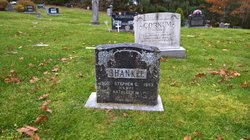
Mamie Susanna Shankle Shankle
| Birth | : | 1903 Nova Scotia, Canada |
| Death | : | 9 May 1992 Nova Scotia, Canada |
| Burial | : | Groesbeek Canadian War Cemetery and Memorial, Groesbeek, Berg en Dal Municipality, Netherlands |
| Coordinate | : | 51.7982900, 5.9321900 |
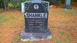
| Inscription | : | Shankle LeRoy 1894 - 1957 (father) Wife Mamie S 1903 - 1992 (mother) |
| Description | : | Shankle, Mamie S - 88, Middle Lahave, Lunenburg County, died May 9 1992 in Victoria General Hospital. Born in Middle Lahave, she was a daughter of the late James and Genetta (Wilkie) Shankle. She is survived by a daughter Rosamond (Mrs Lyman Forcey), Middle Lahave; a sister Grace Lohnes, West Lahave; a brother Arthur, Lewiston, Idaho; four grandchildren; six great grandchildren; two great great grandchildren. She was predeceased by her husband Leroy; four brothers, Fenton, Ray, Stephen, Newton; a half (balance not on copy) (Hfx Chronicle of Mon, May 11 1992, pg C3) With thanks to Richard Noble. |
frequently asked questions (FAQ):
-
Where is Mamie Susanna Shankle Shankle's memorial?
Mamie Susanna Shankle Shankle's memorial is located at: Groesbeek Canadian War Cemetery and Memorial, Groesbeek, Berg en Dal Municipality, Netherlands.
-
When did Mamie Susanna Shankle Shankle death?
Mamie Susanna Shankle Shankle death on 9 May 1992 in Nova Scotia, Canada
-
Where are the coordinates of the Mamie Susanna Shankle Shankle's memorial?
Latitude: 51.7982900
Longitude: 5.9321900
Family Members:
Parent

Spouse

Siblings

Flowers:


Nearby Cemetories:
1. Groesbeek Canadian War Cemetery and Memorial
Groesbeek, Berg en Dal Municipality, Netherlands
Coordinate: 51.7982900, 5.9321900
2. Heilig Landstichting Burial Park
Heilig Landstichting, Berg en Dal Municipality, Netherlands
Coordinate: 51.8173600, 5.8907100
3. Begraafplaats Het Witte Kerkje
Ubbergen, Berg en Dal Municipality, Netherlands
Coordinate: 51.8361166, 5.9018954
4. Joodse Begraafplaats
Nijmegen, Nijmegen Municipality, Netherlands
Coordinate: 51.8308300, 5.8836000
5. Rustoord Cemetery
Nijmegen, Nijmegen Municipality, Netherlands
Coordinate: 51.8305100, 5.8808600
6. Mook War Cemetery
Mook, Mook en Middelaar Municipality, Netherlands
Coordinate: 51.7541200, 5.8854300
7. Mook-en-Middelaar Roman Catholic Churchyard
Mook, Mook en Middelaar Municipality, Netherlands
Coordinate: 51.7531600, 5.8854200
8. Algemene Begraafplaats Stenenkruisstraat
Nijmegen, Nijmegen Municipality, Netherlands
Coordinate: 51.8395021, 5.8679939
9. Saint Bonifacius
Niel, Kreis Kleve, Germany
Coordinate: 51.8261350, 6.0182900
10. Vredehof Cemetery
Nijmegen, Nijmegen Municipality, Netherlands
Coordinate: 51.8147800, 5.8286100
11. Jonkerbos War Cemetery
Nijmegen, Nijmegen Municipality, Netherlands
Coordinate: 51.8222800, 5.8303900
12. Begraafplaats Jonkerbos
Nijmegen, Nijmegen Municipality, Netherlands
Coordinate: 51.8134300, 5.8243700
13. Begraafplaats Graafseweg
Nijmegen, Nijmegen Municipality, Netherlands
Coordinate: 51.8310800, 5.8324100
14. Milsbeek War Cemetery
Milsbeek, Gennep Municipality, Netherlands
Coordinate: 51.7254400, 5.9511900
15. Neerbosch Cemetery
Nijmegen, Nijmegen Municipality, Netherlands
Coordinate: 51.8353200, 5.8192130
16. Friedhof Nütterden
Kranenburg, Kreis Kleve, Germany
Coordinate: 51.7904340, 6.0629380
17. Beers Rooms Katholieke Begraafplaats
Beers, Cuijk Municipality, Netherlands
Coordinate: 51.7261800, 5.8265400
18. Ottersum Roman Catholic Cemetery
Ottersum, Gennep Municipality, Netherlands
Coordinate: 51.7020800, 5.9824600
19. Friedhof Bimmen
Bimmen, Kreis Kleve, Germany
Coordinate: 51.8588737, 6.0695000
20. Reichswald Forest War Cemetery
Kleve, Kreis Kleve, Germany
Coordinate: 51.7406464, 6.0824242
21. Tolkamer General Cemetery
Tolkamer, Rijnwaarden Municipality, Netherlands
Coordinate: 51.8610900, 6.0814200
22. Haaghove
Beuningen, Beuningen Municipality, Netherlands
Coordinate: 51.8666649, 5.7850499
23. Joodse Begraafplaats
Grave Municipality, Netherlands
Coordinate: 51.7548700, 5.7454100
24. Algemene begraafplaats
Grave Municipality, Netherlands
Coordinate: 51.7547000, 5.7454600