Margaret L “Marggie” Ching Grow
| Birth | : | 21 Oct 1921 Castlewood, Hamlin County, South Dakota, USA |
| Death | : | 4 Dec 2008 Janesville, Rock County, Wisconsin, USA |
| Burial | : | Mount Forest Cemetery, Southgate Township, Grey County, Canada |
| Coordinate | : | 44.0039100, -80.7266500 |
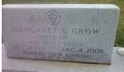
| Inscription | : | Margaret S. Grow Wife of Willard S. Grow Oct. 21, 1921 - Dec. 4, 2008 Married Clem Sonntag June 17, 1972 |
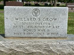
| Description | : | Margaret L "Marggie" Ching Grow Sonntag Her headstone reads "Margaret L. Grow" and she is buried next to her first husband. See inscription below. She was born in Castlewood, South Dakota on October 21, 1921, the daughter of W.H.R. and Annie (Jardine) Ching. She married Willard Grow on August 15, 1941, in Castlewood. They raised their family in Watertown and Marggie and Bill moved to Janesville in 1967. He preceded her in death on October 21, 1970. Margaret later married Clem Sonntag on June 17, 1972. She had worked for many years for the Lein Oil Company in Janesville. She was a... Read More |
frequently asked questions (FAQ):
-
Where is Margaret L “Marggie” Ching Grow's memorial?
Margaret L “Marggie” Ching Grow's memorial is located at: Mount Forest Cemetery, Southgate Township, Grey County, Canada.
-
When did Margaret L “Marggie” Ching Grow death?
Margaret L “Marggie” Ching Grow death on 4 Dec 2008 in Janesville, Rock County, Wisconsin, USA
-
Where are the coordinates of the Margaret L “Marggie” Ching Grow's memorial?
Latitude: 44.0039100
Longitude: -80.7266500
Family Members:
Parent
Spouse
Siblings
Flowers:
Nearby Cemetories:
1. Mount Forest Cemetery
Southgate Township, Grey County, Canada
Coordinate: 44.0039100, -80.7266500
2. Cochrane Cemetery
Mount Forest, Wellington County, Canada
Coordinate: 44.0028500, -80.7740300
3. Holy Cross Roman Catholic Cemetery
Mount Forest, Wellington County, Canada
Coordinate: 43.9679450, -80.7519100
4. Woodland Cemetery
Egremont Township, Grey County, Canada
Coordinate: 44.0238904, -80.6774183
5. Hiltz Methodist Cemetery
Southgate Township, Grey County, Canada
Coordinate: 44.0415434, -80.7565276
6. Chilton Cemetery
Normanby Township, Grey County, Canada
Coordinate: 43.9811480, -80.8129810
7. Holstein Cemetery
Holstein, Grey County, Canada
Coordinate: 44.0708100, -80.7424700
8. Chapel Hill Roman Catholic Cemetery
Orchardville, Grey County, Canada
Coordinate: 44.0547780, -80.7958600
9. Bethel Pioneer Cemetery
Wellington County, Canada
Coordinate: 43.9274480, -80.7271960
10. Riverdale Mennonite Cemetery
Landerkin, Grey County, Canada
Coordinate: 43.9980545, -80.6197205
11. Saint Thomas Roman Catholic Cemetery
Wellington County, Canada
Coordinate: 43.9511810, -80.8071900
12. Farewell Mennonite Cemetery
Farewell, Wellington County, Canada
Coordinate: 43.9053140, -80.7182690
13. Westdale Mennonite Cemetery
Minto, Wellington County, Canada
Coordinate: 43.9300750, -80.8287760
14. Mount Pleasant Cemetery
Calderwood, Grey County, Canada
Coordinate: 44.0185310, -80.8731250
15. Kenilworth Pioneer Catholic Cemetery
Kenilworth, Wellington County, Canada
Coordinate: 43.9085900, -80.6464300
16. Sacred Heart Roman Catholic Cemetery
Kenilworth, Wellington County, Canada
Coordinate: 43.9067993, -80.6410217
17. Maplewood Cemetery
West Grey Township, Grey County, Canada
Coordinate: 44.1159400, -80.8053000
18. Saint Patricks Roman Catholic Cemetery
Cedarville, Grey County, Canada
Coordinate: 44.0309029, -80.5493546
19. Kenilworth Methodist Cemetery
Kenilworth, Wellington County, Canada
Coordinate: 43.8926964, -80.6166458
20. Harriston Cemetery
Harriston, Wellington County, Canada
Coordinate: 43.9139099, -80.8708725
21. Petherton Pioneer Baptist Cemetery
Petherton, Wellington County, Canada
Coordinate: 43.8842850, -80.6084900
22. Trinity Lutheran Cemetery
Ayton, Grey County, Canada
Coordinate: 44.0579900, -80.9234900
23. Saint Peter's Catholic Cemetery
Ayton, Grey County, Canada
Coordinate: 44.0492700, -80.9312200
24. Ayton Evangelical United Brethren Cemetery
Ayton, Grey County, Canada
Coordinate: 44.0588600, -80.9267700


