
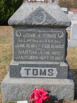
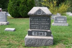
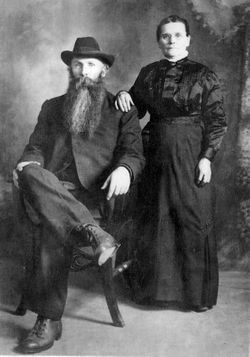
Martha Ann Wolfe Toms
| Birth | : | 17 Jan 1855 Wolfsville, Frederick County, Maryland, USA |
| Death | : | 17 Sep 1937 Thurmont, Frederick County, Maryland, USA |
| Burial | : | All Saints Churchyard, Walton-le-Dale, South Ribble Borough, England |
| Coordinate | : | 53.7407250, -2.6408280 |
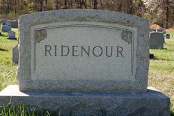
| Description | : | Daughter of Henry and Catherine Wolfe. Wife of John H. Toms. Mother of Mrs. John L. Reacker, Brenton Toms, Franklin Toms, Mrs. Rena Draper, Mrs. Dora Ridenour, Mrs Olevia Myers and Howard Toms. Sister of Mrs. Sheridan Toms and Henry L. Wolfe. Obituary was published in The Frederick Post, Frederick, Maryland, 18 September 1937, page 5. |
frequently asked questions (FAQ):
-
Where is Martha Ann Wolfe Toms's memorial?
Martha Ann Wolfe Toms's memorial is located at: All Saints Churchyard, Walton-le-Dale, South Ribble Borough, England.
-
When did Martha Ann Wolfe Toms death?
Martha Ann Wolfe Toms death on 17 Sep 1937 in Thurmont, Frederick County, Maryland, USA
-
Where are the coordinates of the Martha Ann Wolfe Toms's memorial?
Latitude: 53.7407250
Longitude: -2.6408280
Family Members:
Parent
Spouse
Siblings

Children
Flowers:


Nearby Cemetories:
1. All Saints Churchyard
Walton-le-Dale, South Ribble Borough, England
Coordinate: 53.7407250, -2.6408280
2. Our Lady and St Patrick's Church
Walton-le-Dale, South Ribble Borough, England
Coordinate: 53.7407250, -2.6408280
3. St Leonard Churchyard
Walton-le-Dale, South Ribble Borough, England
Coordinate: 53.7476530, -2.6666950
4. St Mary's Churchyard Brownedge
Bamber Bridge, South Ribble Borough, England
Coordinate: 53.7305472, -2.6669416
5. St. Saviour's Churchyard
Bamber Bridge, South Ribble Borough, England
Coordinate: 53.7197301, -2.6598985
6. St. Leonard the Less Churchyard
Samlesbury, South Ribble Borough, England
Coordinate: 53.7680000, -2.6237000
7. St. Mary's and St. John RC Churchyard, Southworth
Samlesbury, South Ribble Borough, England
Coordinate: 53.7676690, -2.6183400
8. Preston Old Cemetery
Ribbleton, City of Preston, England
Coordinate: 53.7686352, -2.6623154
9. St. Josephs Roman Catholic Churchyard
Brindle, Chorley Borough, England
Coordinate: 53.7350780, -2.5880640
10. St. Bedes Churchyard
Clayton-le-Woods, Chorley Borough, England
Coordinate: 53.7079260, -2.6390320
11. Our Lady and Saint Gerards Churchyard
Lostock Hall, South Ribble Borough, England
Coordinate: 53.7279090, -2.6921460
12. St James's Churchyard
Brindle, Chorley Borough, England
Coordinate: 53.7133333, -2.6086111
13. Preston New Cemetery
Ribbleton, City of Preston, England
Coordinate: 53.7717400, -2.6620900
14. St Augustine of Canterbury
Preston, City of Preston, England
Coordinate: 53.7560420, -2.6912650
15. St. James' Churchyard
Preston, City of Preston, England
Coordinate: 53.7566010, -2.6941110
16. Holy Trinity Churchyard
Hoghton, Chorley Borough, England
Coordinate: 53.7279300, -2.5848550
17. St John Churchyard
Preston, City of Preston, England
Coordinate: 53.7582080, -2.6959750
18. St. Paul Churchyard
Preston, City of Preston, England
Coordinate: 53.7625360, -2.6947080
19. St. Ignatius RC Churchyard
Preston, City of Preston, England
Coordinate: 53.7635270, -2.6965870
20. St. George the Martyr
Preston, City of Preston, England
Coordinate: 53.7591220, -2.7025660
21. St. Wilfrid's Catholic Cemetery
Preston, City of Preston, England
Coordinate: 53.7581670, -2.7044930
22. St Paul Churchyard
Farington, South Ribble Borough, England
Coordinate: 53.7199900, -2.7017200
23. Friends Meeting House Burial Ground (Defunct)
Preston, City of Preston, England
Coordinate: 53.7610250, -2.7030380
24. Holy Trinity
Preston, City of Preston, England
Coordinate: 53.7613030, -2.7030580