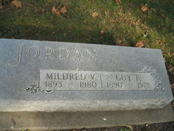
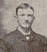
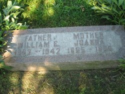
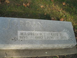
Mildred Viola McGrew Jordan
| Birth | : | 12 Mar 1893 Emerson, Mills County, Iowa, USA |
| Death | : | 29 Dec 1980 Red Oak, Montgomery County, Iowa, USA |
| Burial | : | St Mary and St Chad Churchyard, Brewood, South Staffordshire Borough, England |
| Coordinate | : | 52.6754850, -2.1738520 |
| Plot | : | 2nd Addition, Lot 5 |
| Description | : | FUNERAL SERVCIES FOR MILDRED JORDAN Funeral services for Mildred Viola Jordan, 87, former Red Oak resident, were Friday at Nelson-Boylan Funeral Chapel with Rev. Robert Ruleman officaiting. Burial in Emerson Cemetery. She died last Monday at Montgomery County Memorial Hospital after an extended illness. The daughter of Mr. and Mrs. William McGrew, she was born March 12, 1893 at Emerson and lived in Mills County most of her life until moving to Red Oak in 1975. Since 1978 she had been a resident of Nishna Care Center, Malvern, Iowa. She was married to Guy Francis Jordan in 1920, who died... Read More |
frequently asked questions (FAQ):
-
Where is Mildred Viola McGrew Jordan's memorial?
Mildred Viola McGrew Jordan's memorial is located at: St Mary and St Chad Churchyard, Brewood, South Staffordshire Borough, England.
-
When did Mildred Viola McGrew Jordan death?
Mildred Viola McGrew Jordan death on 29 Dec 1980 in Red Oak, Montgomery County, Iowa, USA
-
Where are the coordinates of the Mildred Viola McGrew Jordan's memorial?
Latitude: 52.6754850
Longitude: -2.1738520
Family Members:
Parent
Spouse
Siblings
Children
Flowers:
Nearby Cemetories:
1. St Mary and St Chad Churchyard
Brewood, South Staffordshire Borough, England
Coordinate: 52.6754850, -2.1738520
2. Saint John's Churchyard
Stretton, South Staffordshire Borough, England
Coordinate: 52.6999790, -2.1720920
3. Christ Church
Gailey, South Staffordshire Borough, England
Coordinate: 52.6933900, -2.1308200
4. Saint Johns Church
Bishops Wood, Shropshire Unitary Authority, England
Coordinate: 52.6810030, -2.2369880
5. All Saints Churchyard
Lapley, South Staffordshire Borough, England
Coordinate: 52.7138900, -2.1902330
6. St. Nicholas' Churchyard
Codsall, South Staffordshire Borough, England
Coordinate: 52.6342500, -2.1992300
7. White Ladies Priory
Boscobel, Shropshire Unitary Authority, England
Coordinate: 52.6657000, -2.2584000
8. St. Michael & All Angels Churchyard
Penkridge, South Staffordshire Borough, England
Coordinate: 52.7245874, -2.1181258
9. Bushbury Cemetery and Crematorium
Bushbury, Metropolitan Borough of Wolverhampton, England
Coordinate: 52.6247480, -2.1083690
10. St. Saviour Churchyard
Hatherton, South Staffordshire Borough, England
Coordinate: 52.6841730, -2.0660840
11. St. Mary's Churchyard
Bushbury, Metropolitan Borough of Wolverhampton, England
Coordinate: 52.6199160, -2.1130120
12. St Andrew Church
Weston-under-Lizard, South Staffordshire Borough, England
Coordinate: 52.6932000, -2.2883000
13. Danescourt Cemetery
Tettenhall, Metropolitan Borough of Wolverhampton, England
Coordinate: 52.6033840, -2.1789160
14. St. Michael and All Angels Churchyard
Tettenhall, Metropolitan Borough of Wolverhampton, England
Coordinate: 52.6003380, -2.1619170
15. St. Cuthbert's Churchyard
Albrighton, Shropshire Unitary Authority, England
Coordinate: 52.6392906, -2.2838705
16. St Mary Magdalene Churchyard
Albrighton, Shropshire Unitary Authority, England
Coordinate: 52.6373060, -2.2831290
17. Cheslyn Hay Cemetery
Cheslyn Hay, South Staffordshire Borough, England
Coordinate: 52.6581170, -2.0431790
18. St. Chad
Boningale, Shropshire Unitary Authority, England
Coordinate: 52.6208330, -2.2795110
19. St Mary and All Saints
Bradley, Stafford Borough, England
Coordinate: 52.7599257, -2.1808769
20. Christ Church
Tettenhall Wood, Metropolitan Borough of Wolverhampton, England
Coordinate: 52.5895828, -2.1805506
21. St. Editha's Parish Church Graveyard
Church Eaton, Stafford Borough, England
Coordinate: 52.7560690, -2.2259540
22. St Mary Roman Catholic Churchyard
Cannock, Cannock Chase District, England
Coordinate: 52.6867620, -2.0283360
23. St. Luke's Churchyard
Cannock, Cannock Chase District, England
Coordinate: 52.6889919, -2.0287352
24. Great Wyrley Cemetery
Great Wyrley, South Staffordshire Borough, England
Coordinate: 52.6642130, -2.0269380

