
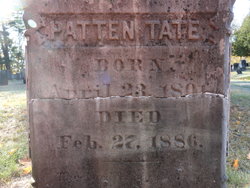
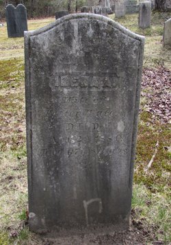
Patten Tate
| Birth | : | 23 Apr 1801 Topsham, Sagadahoc County, Maine, USA |
| Death | : | 27 Feb 1886 Topsham, Sagadahoc County, Maine, USA |
| Burial | : | St. Giles' Churchyard, Skelton, York Unitary Authority, England |
| Coordinate | : | 54.0019111, -1.1342660 |
frequently asked questions (FAQ):
-
Where is Patten Tate's memorial?
Patten Tate's memorial is located at: St. Giles' Churchyard, Skelton, York Unitary Authority, England.
-
When did Patten Tate death?
Patten Tate death on 27 Feb 1886 in Topsham, Sagadahoc County, Maine, USA
-
Where are the coordinates of the Patten Tate's memorial?
Latitude: 54.0019111
Longitude: -1.1342660
Family Members:
Parent
Spouse
Children


Nearby Cemetories:
1. Skelton Parish Council Cemetery
Skelton, York Unitary Authority, England
Coordinate: 54.0070970, -1.1150970
2. St Everilda Churchyard
Nether Poppleton, York Unitary Authority, England
Coordinate: 53.9882060, -1.1403710
3. Moorlands Nature Reserve
Skelton, York Unitary Authority, England
Coordinate: 54.0226680, -1.1201180
4. Holy Evangelists Churchyard
Shipton, Hambleton District, England
Coordinate: 54.0234400, -1.1572300
5. All Saints Churchyard
Upper Poppleton, York Unitary Authority, England
Coordinate: 53.9776970, -1.1510780
6. St. Nicholas' Churchyard
Wigginton, York Unitary Authority, England
Coordinate: 54.0182590, -1.0850720
7. Wigginton Garden of Rest
Wigginton, York Unitary Authority, England
Coordinate: 54.0183970, -1.0851200
8. Haxby and Wigginton Cemetery
Haxby, York Unitary Authority, England
Coordinate: 54.0219200, -1.0808600
9. St Mary Churchyard
Haxby, York Unitary Authority, England
Coordinate: 54.0167790, -1.0754230
10. All Saints Churchyard
Huntington, York Unitary Authority, England
Coordinate: 53.9977460, -1.0633490
11. St Barnabas Church
York, York Unitary Authority, England
Coordinate: 53.9639530, -1.1030490
12. St Stephen Churchyard
Acomb, York Unitary Authority, England
Coordinate: 53.9558840, -1.1289100
13. St John's the Baptist Church
Hessay, York Unitary Authority, England
Coordinate: 53.9767283, -1.2027246
14. St Olave Churchyard
York, York Unitary Authority, England
Coordinate: 53.9622570, -1.0891560
15. St Giles Churchyard
York, York Unitary Authority, England
Coordinate: 53.9640010, -1.0843930
16. Abbey of St Mary (defunct)
York, York Unitary Authority, England
Coordinate: 53.9620290, -1.0883600
17. New Lane Cemetery
Huntington, York Unitary Authority, England
Coordinate: 53.9816223, -1.0576156
18. Lendal Congregational Chapel
York, York Unitary Authority, England
Coordinate: 53.9606360, -1.0860970
19. St Wilfred Churchyard
York, York Unitary Authority, England
Coordinate: 53.9610550, -1.0848990
20. St Michael le Belfrey Churchyard
York, York Unitary Authority, England
Coordinate: 53.9618620, -1.0829730
21. York Cholera Burial Ground
York, York Unitary Authority, England
Coordinate: 53.9586930, -1.0908420
22. Blackfriars Abbey Church (Defunct)
York, York Unitary Authority, England
Coordinate: 53.9594100, -1.0880900
23. York Minster
York, York Unitary Authority, England
Coordinate: 53.9619440, -1.0819440
24. Augustinian Friary, York (Nonextant)
York, York Unitary Authority, England
Coordinate: 53.9601683, -1.0860521