
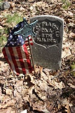
Pvt Joseph Clark Plaisted
| Birth | : | 1841 New Hampshire, USA |
| Death | : | 8 Apr 1862 Holderness, Grafton County, New Hampshire, USA |
| Burial | : | High Street Cemetery, Greenfield, Franklin County, USA |
| Coordinate | : | 42.6044840, -72.5806660 |
| Inscription | : | CO.A 6TH N.H.INF. |
| Description | : | Son of Cyrus C. Plaisted and Elizabeth (Eliza) E Rowe. Soldier in the Civil War. Co. A, 6th NH Infantry. *Death date from: Revised Register of the Soldiers and Sailors of New Hampshire in the War of the Rebellion, 1861-1866, Augustus D. Ayling, Adjutant General, published 1895, Concord (Ancestry.com database on-line); and Headstones Provided for Deceased Union Civil War Veterans, 1879-1903 (Ancestry.com, database on-line), image #512. Approximate birth date from Revised Register ... (above), and from 1850 and 1860 US Census, Grafton County, Holderness, family of Cyrus Plaisted, name of "Clark Plaisted". *courtesy of contributor #47672787 wwphil |
frequently asked questions (FAQ):
-
Where is Pvt Joseph Clark Plaisted's memorial?
Pvt Joseph Clark Plaisted's memorial is located at: High Street Cemetery, Greenfield, Franklin County, USA.
-
When did Pvt Joseph Clark Plaisted death?
Pvt Joseph Clark Plaisted death on 8 Apr 1862 in Holderness, Grafton County, New Hampshire, USA
-
Where are the coordinates of the Pvt Joseph Clark Plaisted's memorial?
Latitude: 42.6044840
Longitude: -72.5806660
Family Members:
Parent

Siblings
Flowers:


Nearby Cemetories:
1. High Street Cemetery
Greenfield, Franklin County, USA
Coordinate: 42.6044840, -72.5806660
2. Federal Street Cemetery
Greenfield, Franklin County, USA
Coordinate: 42.5941400, -72.5977300
3. Fairway Avenue Cemetery
Montague, Franklin County, USA
Coordinate: 42.5924270, -72.5646970
4. Burnham Cemetery
Montague, Franklin County, USA
Coordinate: 42.5875300, -72.5720140
5. Springdale Cemetery
Montague, Franklin County, USA
Coordinate: 42.5884700, -72.5530900
6. Green River Cemetery
Greenfield, Franklin County, USA
Coordinate: 42.5804400, -72.6052500
7. Saint Annes Cemetery
Montague, Franklin County, USA
Coordinate: 42.5861300, -72.5480600
8. Lower Meadow Cemetery
Greenfield, Franklin County, USA
Coordinate: 42.5945600, -72.6200300
9. Saint Marys Cemetery
Montague, Franklin County, USA
Coordinate: 42.5852200, -72.5475100
10. Riverside Cemetery
Gill, Franklin County, USA
Coordinate: 42.6156006, -72.5410995
11. Old Catholic Cemetery
Greenfield, Franklin County, USA
Coordinate: 42.5795753, -72.6064215
12. Our Lady of Czestochowa Cemetery
Montague, Franklin County, USA
Coordinate: 42.5846000, -72.5469400
13. Aaron Clark Memorial Cemetery
Montague, Franklin County, USA
Coordinate: 42.5836200, -72.5471600
14. Log Plain Cemetery
Greenfield, Franklin County, USA
Coordinate: 42.6378320, -72.5725800
15. Calvary Cemetery
Greenfield, Franklin County, USA
Coordinate: 42.5764008, -72.6138992
16. Greenfield Hebrew Congregation Cemetery
Greenfield, Franklin County, USA
Coordinate: 42.6409410, -72.5653360
17. Mater Dolorosa Cemetery
Greenfield, Franklin County, USA
Coordinate: 42.5758000, -72.6165000
18. North Meadows Cemetery
Greenfield, Franklin County, USA
Coordinate: 42.6171989, -72.6333008
19. Country Farms Cemetery
Greenfield, Franklin County, USA
Coordinate: 42.6393900, -72.6165400
20. East Deerfield Cemetery
Deerfield, Franklin County, USA
Coordinate: 42.5555992, -72.5642014
21. North Cemetery
Deerfield, Franklin County, USA
Coordinate: 42.5635100, -72.6249200
22. West Gill Cemetery
Gill, Franklin County, USA
Coordinate: 42.6442700, -72.5280500
23. East Mineral Road Cemetery
Montague, Franklin County, USA
Coordinate: 42.5810500, -72.5086300
24. Baptist Cemetery
Deerfield, Franklin County, USA
Coordinate: 42.5555992, -72.6258011