
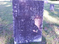
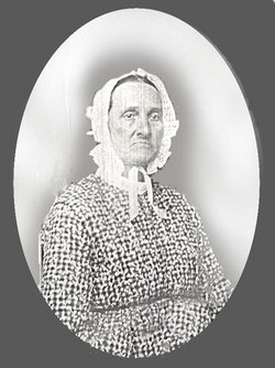
Rebecca Billings Witham
| Birth | : | 28 Jul 1791 |
| Death | : | 28 Sep 1853 |
| Burial | : | St. Mary's and St. John RC Churchyard, Southworth, Samlesbury, South Ribble Borough, England |
| Coordinate | : | 53.7676690, -2.6183400 |
| Description | : | The Records of the Church of Christ in Buxton, Maine, as well as the New England Historical and Genealogical Register, 96:177, "The Saco, Maine, Descendants of Nathaniel Billings of Concord, Massachusetts," records a 1788 marriage for Joseph Billings and Lydia Hobson, whom researchers believe to be the parents of Rebecca Billings. Rebecca and her brother were born in Maine, but their four other known siblings were part of a larger group that traveled to Ohio and then Indiana in the early 1800s. It is speculated that it was in either Hamilton County, Ohio, or Union County, Indiana, that Rebecca married Morris... Read More |
frequently asked questions (FAQ):
-
Where is Rebecca Billings Witham's memorial?
Rebecca Billings Witham's memorial is located at: St. Mary's and St. John RC Churchyard, Southworth, Samlesbury, South Ribble Borough, England.
-
When did Rebecca Billings Witham death?
Rebecca Billings Witham death on 28 Sep 1853 in
-
Where are the coordinates of the Rebecca Billings Witham's memorial?
Latitude: 53.7676690
Longitude: -2.6183400
Family Members:
Parent
Spouse
Siblings

Children
Flowers:


Nearby Cemetories:
1. St. Mary's and St. John RC Churchyard, Southworth
Samlesbury, South Ribble Borough, England
Coordinate: 53.7676690, -2.6183400
2. St. Leonard the Less Churchyard
Samlesbury, South Ribble Borough, England
Coordinate: 53.7680000, -2.6237000
3. Preston Crematorium
Preston, City of Preston, England
Coordinate: 53.7863750, -2.6340170
4. Preston Old Cemetery
Ribbleton, City of Preston, England
Coordinate: 53.7686352, -2.6623154
5. Preston New Cemetery
Ribbleton, City of Preston, England
Coordinate: 53.7717400, -2.6620900
6. All Saints Churchyard
Walton-le-Dale, South Ribble Borough, England
Coordinate: 53.7407250, -2.6408280
7. Our Lady and St Patrick's Church
Walton-le-Dale, South Ribble Borough, England
Coordinate: 53.7407250, -2.6408280
8. St. Michael's Churchyard
Grimsargh, City of Preston, England
Coordinate: 53.7990710, -2.6352530
9. St Leonard Churchyard
Walton-le-Dale, South Ribble Borough, England
Coordinate: 53.7476530, -2.6666950
10. St. Josephs Roman Catholic Churchyard
Brindle, Chorley Borough, England
Coordinate: 53.7350780, -2.5880640
11. St Leonard Churchyard
Balderstone, Ribble Valley Borough, England
Coordinate: 53.7860070, -2.5609380
12. Our Lady and St. Michael Roman Catholic Churchyard
Longridge, Ribble Valley Borough, England
Coordinate: 53.8088040, -2.6133470
13. Holy Trinity Churchyard
Hoghton, Chorley Borough, England
Coordinate: 53.7279300, -2.5848550
14. St Augustine of Canterbury
Preston, City of Preston, England
Coordinate: 53.7560420, -2.6912650
15. St. Paul Churchyard
Preston, City of Preston, England
Coordinate: 53.7625360, -2.6947080
16. St. James' Churchyard
Preston, City of Preston, England
Coordinate: 53.7566010, -2.6941110
17. St. Ignatius RC Churchyard
Preston, City of Preston, England
Coordinate: 53.7635270, -2.6965870
18. St John Churchyard
Preston, City of Preston, England
Coordinate: 53.7582080, -2.6959750
19. St Mary's Churchyard Brownedge
Bamber Bridge, South Ribble Borough, England
Coordinate: 53.7305472, -2.6669416
20. St. Mary's Churchyard
Preston, City of Preston, England
Coordinate: 53.8010830, -2.6779600
21. Holy Trinity
Preston, City of Preston, England
Coordinate: 53.7613030, -2.7030580
22. Friends Meeting House Burial Ground (Defunct)
Preston, City of Preston, England
Coordinate: 53.7610250, -2.7030380
23. St. George the Martyr
Preston, City of Preston, England
Coordinate: 53.7591220, -2.7025660
24. Christ Church Churchyard
Fulwood, City of Preston, England
Coordinate: 53.7771920, -2.7028700