
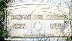
Richard Lee Bartsch
| Birth | : | 9 Jan 1941 |
| Death | : | 5 Jul 2006 |
| Burial | : | Herne Bay Cemetery, Herne Bay, City of Canterbury, England |
| Coordinate | : | 51.3571810, 1.1304820 |
| Description | : | Richard was born on January 9, 1941 in Miles City, Montana, the son of Carl LeRoy and Bessie Marie (Coltrin) Bartsch. He was raised and attended grade schools and high school in Miles City. After his schooling he had done several odd jobs around Miles City as well as working at E.M.I. Due to ill health, Richard moved into the Friendship Villa Care Center in April of 2005, where he has remained ever since. Richard is survived by a brother, Carl Bartsch of Denver, CO, an aunt, Edith Allison of Miles City, MT, an uncle,... Read More |
frequently asked questions (FAQ):
-
Where is Richard Lee Bartsch's memorial?
Richard Lee Bartsch's memorial is located at: Herne Bay Cemetery, Herne Bay, City of Canterbury, England.
-
When did Richard Lee Bartsch death?
Richard Lee Bartsch death on 5 Jul 2006 in
-
Where are the coordinates of the Richard Lee Bartsch's memorial?
Latitude: 51.3571810
Longitude: 1.1304820
Family Members:
Parent

Flowers:


Nearby Cemetories:
1. Herne Bay Cemetery
Herne Bay, City of Canterbury, England
Coordinate: 51.3571810, 1.1304820
2. St Martins
Herne, City of Canterbury, England
Coordinate: 51.3500600, 1.1333200
3. St Martin's Churchyard
Herne, City of Canterbury, England
Coordinate: 51.3497060, 1.1334370
4. St Mary the Virgin Churchyard
Reculver, City of Canterbury, England
Coordinate: 51.3684750, 1.1766050
5. St John the Baptist Churchyard
Swalecliffe, City of Canterbury, England
Coordinate: 51.3645500, 1.0667200
6. St Mary The Virgin Churchyard
Chislet, City of Canterbury, England
Coordinate: 51.3343610, 1.1921020
7. St Mary's Abbey
Reculver, City of Canterbury, England
Coordinate: 51.3795360, 1.1993770
8. All Saints Churchyard
Westbere, City of Canterbury, England
Coordinate: 51.3065380, 1.1437670
9. Sturry Cemetery
Sturry, City of Canterbury, England
Coordinate: 51.3058100, 1.1277700
10. All Saints Churchyard
Whitstable, City of Canterbury, England
Coordinate: 51.3558090, 1.0396670
11. St Nicholas Churchyard
Sturry, City of Canterbury, England
Coordinate: 51.2984830, 1.1201330
12. Whitstable Cemetery
Whitstable, City of Canterbury, England
Coordinate: 51.3529870, 1.0338530
13. St Mary the Virgin Churchyard
Fordwich, City of Canterbury, England
Coordinate: 51.2958300, 1.1270530
14. Stodmarsh St Marys Churchyard
Wickhambreaux, City of Canterbury, England
Coordinate: 51.3009500, 1.1836900
15. St Alphege Churchyard
Whitstable, City of Canterbury, England
Coordinate: 51.3576330, 1.0251080
16. St Cosmus and St Damian Churchyard
Blean, City of Canterbury, England
Coordinate: 51.3052720, 1.0530480
17. St. Nicholas' Churchyard
St Nicholas at Wade, Thanet District, England
Coordinate: 51.3542160, 1.2517980
18. All Saints Churchyard
Stourmouth, Dover District, England
Coordinate: 51.3202600, 1.2365520
19. St Nicholas-at-Wade Cemetery
St Nicholas at Wade, Thanet District, England
Coordinate: 51.3578344, 1.2534168
20. St Gregory's Priory (defunct)
Canterbury, City of Canterbury, England
Coordinate: 51.2831127, 1.0855358
21. St. John the Baptist Hospital Chapelyard
Canterbury, City of Canterbury, England
Coordinate: 51.2832713, 1.0837677
22. St Andrew Churchyard
Wickhambreaux, City of Canterbury, England
Coordinate: 51.2844400, 1.1822300
23. St Gregory Churchyard
Canterbury, City of Canterbury, England
Coordinate: 51.2816050, 1.0887840
24. St Mildred Churchyard
Preston, Dover District, England
Coordinate: 51.2985000, 1.2173980