
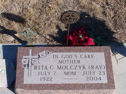
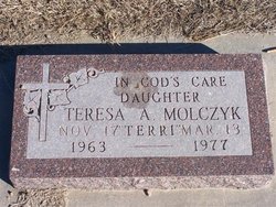
Rita Caroline Ray Molczyk
| Birth | : | 7 Jul 1922 Spalding, Greeley County, Nebraska, USA |
| Death | : | 23 Jul 2004 Spalding, Greeley County, Nebraska, USA |
| Burial | : | Christ Churchyard, Sandown, Isle of Wight Unitary Authority, England |
| Coordinate | : | 50.6521319, -1.1621056 |
| Description | : | Married to Ted Molczyk on 11-18-1944 at St. Michael's Catholic Church at Spalding, NE. |
frequently asked questions (FAQ):
-
Where is Rita Caroline Ray Molczyk's memorial?
Rita Caroline Ray Molczyk's memorial is located at: Christ Churchyard, Sandown, Isle of Wight Unitary Authority, England.
-
When did Rita Caroline Ray Molczyk death?
Rita Caroline Ray Molczyk death on 23 Jul 2004 in Spalding, Greeley County, Nebraska, USA
-
Where are the coordinates of the Rita Caroline Ray Molczyk's memorial?
Latitude: 50.6521319
Longitude: -1.1621056
Family Members:
Parent
Spouse

Siblings
Children

Flowers:


Nearby Cemetories:
1. Christ Churchyard
Sandown, Isle of Wight Unitary Authority, England
Coordinate: 50.6521319, -1.1621056
2. Lake Cemetery
Lake, Isle of Wight Unitary Authority, England
Coordinate: 50.6498713, -1.1734786
3. Shanklin Cemetery
Sandown, Isle of Wight Unitary Authority, England
Coordinate: 50.6445083, -1.1742694
4. Shanklin Cemetery
Shanklin, Isle of Wight Unitary Authority, England
Coordinate: 50.6441740, -1.1738343
5. St Mary the Virgin Churchyard
Brading, Isle of Wight Unitary Authority, England
Coordinate: 50.6824400, -1.1429600
6. St Boniface Bonchurch Churchyard
Bonchurch, Isle of Wight Unitary Authority, England
Coordinate: 50.6000880, -1.1867990
7. St Boniface Old Churchyard
Bonchurch, Isle of Wight Unitary Authority, England
Coordinate: 50.5988889, -1.1850000
8. Lane End Cemetery
Bembridge, Isle of Wight Unitary Authority, England
Coordinate: 50.6863554, -1.0809575
9. All Saints Churchyard
Godshill, Isle of Wight Unitary Authority, England
Coordinate: 50.6336900, -1.2558300
10. St. Johns Churchyard
Ryde, Isle of Wight Unitary Authority, England
Coordinate: 50.7149770, -1.1482370
11. St Peter's
Havenstreet, Isle of Wight Unitary Authority, England
Coordinate: 50.7095580, -1.2063290
12. Ryde Cemetery
Ryde, Isle of Wight Unitary Authority, England
Coordinate: 50.7249730, -1.1668550
13. Binstead Cemetery
Binstead, Isle of Wight Unitary Authority, England
Coordinate: 50.7264610, -1.1866180
14. St Cecilia's Abbey
Ryde, Isle of Wight Unitary Authority, England
Coordinate: 50.7279800, -1.1463120
15. St Thomas Churchyard
Ryde, Isle of Wight Unitary Authority, England
Coordinate: 50.7305600, -1.1632540
16. Holy Cross Churchyard
Binstead, Isle of Wight Unitary Authority, England
Coordinate: 50.7320080, -1.1863070
17. Quarr Old Abbey
Ryde, Isle of Wight Unitary Authority, England
Coordinate: 50.7310000, -1.1996000
18. Old Church of St Lawrence
Ventnor, Isle of Wight Unitary Authority, England
Coordinate: 50.5871078, -1.2438191
19. Quarr Abbey
Binstead, Isle of Wight Unitary Authority, England
Coordinate: 50.7311862, -1.2034333
20. Parish Church of St. Lawrence
Ventnor, Isle of Wight Unitary Authority, England
Coordinate: 50.5858807, -1.2436714
21. Whitwell New Burial Ground
Whitwell, Isle of Wight Unitary Authority, England
Coordinate: 50.5943366, -1.2689275
22. St Olave's Churchyard
Gatcombe, Isle of Wight Unitary Authority, England
Coordinate: 50.6636110, -1.3041670
23. St. Edmund's Churchyard
Wootton, Isle of Wight Unitary Authority, England
Coordinate: 50.7308220, -1.2344490
24. Isle of Wight Crematorium
Whippingham, Isle of Wight Unitary Authority, England
Coordinate: 50.7217910, -1.2573910