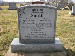
Rita Jo Fleishour Smith
| Birth | : | 20 Apr 1956 Canton, Stark County, Ohio, USA |
| Death | : | 20 May 1995 Shawnee, Pottawatomie County, Oklahoma, USA |
| Burial | : | Kilgore Cemetery, Kilgore, Carroll County, USA |
| Coordinate | : | 40.4632988, -81.0014038 |
| Description | : | Her obituary in the Free Press Standard, Carrollton, Ohio, Thursday, May 25, 1995. Rita Jo Smith, 39, of Shawnee, Oklahoma, formerly of East Springfield, died May 20 in Shawnee following a brief illness. Born April 20, 1956, at Canton, she was a daughter of Ray Fleishour, Sr. of East Springfield and Edna (Bright) Fleishour Sperry of Carrollton. She was a graduate of Springfield High School and Jefferson Technical College. She was a program manager at Tinker Air Force Base and recently a full time homemaker. In addition to her parents she is survived by her... Read More |
frequently asked questions (FAQ):
-
Where is Rita Jo Fleishour Smith's memorial?
Rita Jo Fleishour Smith's memorial is located at: Kilgore Cemetery, Kilgore, Carroll County, USA.
-
When did Rita Jo Fleishour Smith death?
Rita Jo Fleishour Smith death on 20 May 1995 in Shawnee, Pottawatomie County, Oklahoma, USA
-
Where are the coordinates of the Rita Jo Fleishour Smith's memorial?
Latitude: 40.4632988
Longitude: -81.0014038
Family Members:
Parent
Flowers:
Nearby Cemetories:
1. Kilgore Presbyterian Cemetery
Carroll County, USA
Coordinate: 40.4603004, -81.0002975
2. Abel Cemetery
Carroll County, USA
Coordinate: 40.4578018, -81.0113983
3. Simmons Cemetery
Carroll County, USA
Coordinate: 40.4622002, -80.9783020
4. Simmons Ridge Cemetery
Carroll County, USA
Coordinate: 40.4757996, -80.9621964
5. Crawford Cemetery
Lee Township, Carroll County, USA
Coordinate: 40.4935030, -80.9578650
6. Allen Memorial Cemetery
Carroll County, USA
Coordinate: 40.4364014, -81.0511017
7. Arabia Cemetery
Perrysville, Carroll County, USA
Coordinate: 40.4803009, -81.0678024
8. Harlem Springs Cemetery
Harlem Springs, Carroll County, USA
Coordinate: 40.5219002, -81.0053024
9. Amsterdam Cemetery
Loudon Township, Carroll County, USA
Coordinate: 40.4752998, -80.9250031
10. Saint Joseph Cemetery
Amsterdam, Jefferson County, USA
Coordinate: 40.4756230, -80.9229770
11. United Brethren Cemetery
Harrison County, USA
Coordinate: 40.4043999, -81.0353012
12. Evangelical Lutheran Cemetery
New Rumley, Harrison County, USA
Coordinate: 40.4019012, -81.0271988
13. Germano Cemetery
Germano, Harrison County, USA
Coordinate: 40.4108009, -80.9522018
14. New Rumley Methodist Cemetery
New Rumley, Harrison County, USA
Coordinate: 40.4028015, -81.0346985
15. Wells-Jackman Cemetery
Carroll County, USA
Coordinate: 40.5177994, -80.9522018
16. Mizer Cemetery
Amsterdam, Jefferson County, USA
Coordinate: 40.4318450, -80.9247940
17. Wood Cemetery
Scio, Harrison County, USA
Coordinate: 40.4193500, -81.0707690
18. Green Hill Cemetery
Carroll County, USA
Coordinate: 40.5303001, -81.0246964
19. Perrysville United Methodist Cemetery
Perrysville, Carroll County, USA
Coordinate: 40.4625510, -81.0973610
20. Perrysville Methodist Episcopal Church Cemetery
Perrysville, Carroll County, USA
Coordinate: 40.4655991, -81.0982971
21. Amsterdam Catholic Cemetery
Amsterdam, Jefferson County, USA
Coordinate: 40.4899390, -80.9093740
22. Hagey Family Cemetery
Perrysville, Carroll County, USA
Coordinate: 40.4525980, -81.0996160
23. New Perrysville Cemetery
Perrysville, Carroll County, USA
Coordinate: 40.4569016, -81.1016998
24. Lee Cemetery
Carroll County, USA
Coordinate: 40.5391998, -81.0314026


