
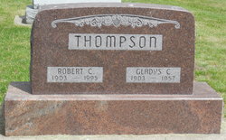
Robert Clark Thompson
| Birth | : | 22 Oct 1903 Fairfield, Jefferson County, Iowa, USA |
| Death | : | 20 Nov 1995 Garner, Hancock County, Iowa, USA |
| Burial | : | Bourne Cemetery, Bourne, South Kesteven District, England |
| Coordinate | : | 52.7607264, -0.3714663 |
| Plot | : | Block 8, Lot 56, Grave 5 |
| Description | : | MCGG 11/21/1995 Robert C. Thompson GARNER Robert C. Thompson, 92, of Garner, died Monday (Nov. 20, 1995) at Concord Care Centerr. Funeral services will be held 10:30 a.m. Friday at St. Paul Lutheran Church, with the Rev. James Lamb and the Rev. Clyde Kieschnick officiating. Burial will be in Concord Township Cemetery. Visitation will be from 5 to 8 p.m. Thursday at the Cataldo Funeral Chapel, 160 E. Fourth St. Robert Clark Thompson was born Oct. 22, 1903, on a farm near Fairfield. Survivors include his wife, Myrtle Thompson of Garner. He was preceded in death by his first wife, parents, one sister and one brother. |
frequently asked questions (FAQ):
-
Where is Robert Clark Thompson's memorial?
Robert Clark Thompson's memorial is located at: Bourne Cemetery, Bourne, South Kesteven District, England.
-
When did Robert Clark Thompson death?
Robert Clark Thompson death on 20 Nov 1995 in Garner, Hancock County, Iowa, USA
-
Where are the coordinates of the Robert Clark Thompson's memorial?
Latitude: 52.7607264
Longitude: -0.3714663
Family Members:
Parent

Spouse

Siblings

Flowers:


Nearby Cemetories:
1. Bourne Cemetery
Bourne, South Kesteven District, England
Coordinate: 52.7607264, -0.3714663
2. Bourne Abbey
Bourne, South Kesteven District, England
Coordinate: 52.7661320, -0.3758389
3. St Firmin Churchyard
Thurlby, South Kesteven District, England
Coordinate: 52.7375960, -0.3646650
4. St Michael Churchyard
Edenham, South Kesteven District, England
Coordinate: 52.7836110, -0.4266560
5. St John the Baptist Churchyard
Morton, South Kesteven District, England
Coordinate: 52.8025100, -0.3724200
6. Baston Cemetery
Baston, South Kesteven District, England
Coordinate: 52.7149917, -0.3531338
7. St John the Baptist Churchyard
Baston, South Kesteven District, England
Coordinate: 52.7149530, -0.3530650
8. St. Andrews Churchyard
Witham on the Hill, South Kesteven District, England
Coordinate: 52.7364500, -0.4420300
9. St Faith Churchyard
Wilsthorpe, South Kesteven District, England
Coordinate: 52.7095208, -0.3848166
10. St Andrew's Churchyard
Haconby, South Kesteven District, England
Coordinate: 52.8135400, -0.3594300
11. St Michael and All Angels Churchyard
Langtoft, South Kesteven District, England
Coordinate: 52.6990300, -0.3389800
12. Saint Stephen
Carlby, South Kesteven District, England
Coordinate: 52.7125650, -0.4475800
13. St Stephen Churchyard
Careby, South Kesteven District, England
Coordinate: 52.7363500, -0.4823700
14. St Mary Magdalene Churchyard
Essendine, Rutland Unitary Authority, England
Coordinate: 52.7026000, -0.4489000
15. St Andrew's Churchyard
Rippingale, South Kesteven District, England
Coordinate: 52.8366700, -0.3718000
16. St Martin Churchyard
Barholm, South Kesteven District, England
Coordinate: 52.6855000, -0.3887600
17. St Peter Churchyard
Creeton, South Kesteven District, England
Coordinate: 52.7669500, -0.4977300
18. St Mary Churchyard
Swinstead, South Kesteven District, England
Coordinate: 52.7900380, -0.4909380
19. St Medard and St Gildard Churchyard
Little Bytham, South Kesteven District, England
Coordinate: 52.6786110, -0.3200000
20. St Wilfrid
Holywell, South Kesteven District, England
Coordinate: 52.7329915, -0.5149881
21. St John the Evangelist Churchyard
Ryhall, Rutland Unitary Authority, England
Coordinate: 52.6852000, -0.4685000
22. Ryhall Churchyard Extension
Ryhall, Rutland Unitary Authority, England
Coordinate: 52.6849000, -0.4678700
23. St. Andrew's Churchyard
West Deeping, South Kesteven District, England
Coordinate: 52.6640285, -0.3614634
24. Aslackby Cemetery
Aslackby, South Kesteven District, England
Coordinate: 52.8597838, -0.3855002