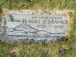
Robert Paul “Scoobie” Manicke
| Birth | : | 15 Jun 1928 Pateros, Okanogan County, Washington, USA |
| Death | : | 9 Feb 2000 Pateros, Okanogan County, Washington, USA |
| Burial | : | Walnut Hills Jewish Cemetery, Evanston, Hamilton County, USA |
| Coordinate | : | 39.1403700, -84.4731300 |
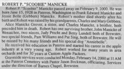
| Description | : | Robert P. "Scoobie" Manicke, 71, of Pateros, died Wednesday, Feb. 9, 2000. He was born and grew up in Pateros. He started his career in the apple industry at a very young age and worked for many years in orchards and for Custom Apple Packers for 30 years. Survivors include a brother, John Manicke of Wenatchee. Graveside services will be held at 11 a.m. Monday at the Pateros Cemetery, Pastor Jason Beckman officiating. Arrangements are by Barnes Chapel, Brewster. Robert P "Scoobie" Manicke passed away on February 9, 2000. He was born June 15, 1928 in Pateros, Washington to Frank Edward Manicke and Jessie Belle... Read More |
frequently asked questions (FAQ):
-
Where is Robert Paul “Scoobie” Manicke's memorial?
Robert Paul “Scoobie” Manicke's memorial is located at: Walnut Hills Jewish Cemetery, Evanston, Hamilton County, USA.
-
When did Robert Paul “Scoobie” Manicke death?
Robert Paul “Scoobie” Manicke death on 9 Feb 2000 in Pateros, Okanogan County, Washington, USA
-
Where are the coordinates of the Robert Paul “Scoobie” Manicke's memorial?
Latitude: 39.1403700
Longitude: -84.4731300
Family Members:
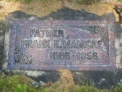
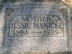
Parent
Siblings
Flowers:
Nearby Cemetories:
1. Walnut Hills Jewish Cemetery
Evanston, Hamilton County, USA
Coordinate: 39.1403700, -84.4731300
2. Calvary Cemetery
Cincinnati, Hamilton County, USA
Coordinate: 39.1403008, -84.4697037
3. Walnut Hills Cemetery
Cincinnati, Hamilton County, USA
Coordinate: 39.1355950, -84.4809040
4. First German Protestant Cemetery
Avondale, Hamilton County, USA
Coordinate: 39.1492004, -84.4863968
5. Fulton Cemetery
Hyde Park, Hamilton County, USA
Coordinate: 39.1406364, -84.4506302
6. Methodist Protestant Cemetery (Defunct)
Cincinnati, Hamilton County, USA
Coordinate: 39.1324770, -84.4983160
7. Knox Presbyterian Church
Cincinnati, Hamilton County, USA
Coordinate: 39.1378980, -84.4415180
8. Saint Mary Cemetery
Saint Bernard, Hamilton County, USA
Coordinate: 39.1664009, -84.4880981
9. Vine Street Hill Cemetery
Cincinnati, Hamilton County, USA
Coordinate: 39.1516991, -84.5091019
10. Joseph of Arimethea Columbarium
Cincinnati, Hamilton County, USA
Coordinate: 39.1389470, -84.4336500
11. Hyde Park Community UMC Columbarium
Hyde Park, Hamilton County, USA
Coordinate: 39.1363820, -84.4326970
12. Saint Francis of Assisi Roman Catholic Cemetery
Dayton, Campbell County, USA
Coordinate: 39.1115840, -84.4545220
13. Saint John Cemetery
Saint Bernard, Hamilton County, USA
Coordinate: 39.1643982, -84.5053024
14. Hillside Chapel Crematory and Columbarium
Cincinnati, Hamilton County, USA
Coordinate: 39.1393509, -84.5247192
15. Christ Church Cemetery
Over-The-Rhine, Hamilton County, USA
Coordinate: 39.1126480, -84.5157623
16. Clifton United Jewish Cemetery
Cincinnati, Hamilton County, USA
Coordinate: 39.1470871, -84.5292816
17. Fulton-Presbyterian Cemetery
Fulton, Hamilton County, USA
Coordinate: 39.1074982, -84.4332962
18. Thomas Williams Cemetery (Defunct)
Cincinnati, Hamilton County, USA
Coordinate: 39.1085060, -84.5146050
19. Fulton Cemetery #2
Columbia, Hamilton County, USA
Coordinate: 39.1067543, -84.4332809
20. Spring Grove Cemetery
Cincinnati, Hamilton County, USA
Coordinate: 39.1647900, -84.5231500
21. Christ Episcopal Churchyard (Defunct)
Cincinnati, Hamilton County, USA
Coordinate: 39.1100520, -84.5177220
22. Wesleyan Chapel Methodist Church Cemetery
Cincinnati, Hamilton County, USA
Coordinate: 39.1022390, -84.5073540
23. Potters Field
Cincinnati, Hamilton County, USA
Coordinate: 39.1094440, -84.5188890
24. Presbyterian Burying Ground
Cincinnati, Hamilton County, USA
Coordinate: 39.1082510, -84.5175720

