
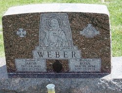
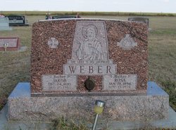
Rosa Herrman Weber
| Birth | : | 20 Jan 1894 Liebenthal, Rush County, Kansas, USA |
| Death | : | 13 Nov 1974 Quinter, Gove County, Kansas, USA |
| Burial | : | Christ Church Churchyard Westerdale, Westerdale, Scarborough Borough, England |
| Coordinate | : | 54.4450870, -0.9781360 |
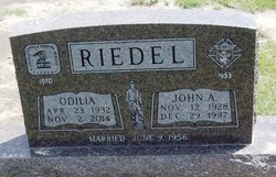
| Description | : | Mrs. Rosa Weber was born Rosa Herrman on January 28, 1894, at Liebenthal. She died at Gove County Hospital, Quinter. Jakob Weber and Rosa Herrman were married May 27, 1913, at Liebenthal. Mrs. Weber was a longtime resident of Park and was a member of Sacred Heart Roman Catholic Church and the Daughters of Isabella. Survivors included the widower, Jakob; 8 sons, Msgr. John George Weber, Bartholomew Weber, Henry Weber, Anthony Weber, Larry Weber, Martin Weber, Silvenus Weber, and Aloysius Weber; 4 daughters, Mrs. Philomena (Minnie) Christenson, Mrs. Magdalena Gassman, Mrs. Marie Meier and Mrs. Odilia Reidel; a brother, Aloysius... Read More |
frequently asked questions (FAQ):
-
Where is Rosa Herrman Weber's memorial?
Rosa Herrman Weber's memorial is located at: Christ Church Churchyard Westerdale, Westerdale, Scarborough Borough, England.
-
When did Rosa Herrman Weber death?
Rosa Herrman Weber death on 13 Nov 1974 in Quinter, Gove County, Kansas, USA
-
Where are the coordinates of the Rosa Herrman Weber's memorial?
Latitude: 54.4450870
Longitude: -0.9781360
Family Members:
Parent
Spouse
Siblings
Children
Flowers:


Nearby Cemetories:
1. Christ Church Churchyard Westerdale
Westerdale, Scarborough Borough, England
Coordinate: 54.4450870, -0.9781360
2. Westerdale Green Burial Ground
Westerdale, Scarborough Borough, England
Coordinate: 54.4409040, -0.9555864
3. Quakers Burial Ground
Castleton, Scarborough Borough, England
Coordinate: 54.4614010, -0.9478360
4. St Hilda Churchyard
Danby, Scarborough Borough, England
Coordinate: 54.4475240, -0.9281480
5. Botton Village Cemetery
Danby, Scarborough Borough, England
Coordinate: 54.4290000, -0.9282700
6. St Peter Churchyard
Commondale, Scarborough Borough, England
Coordinate: 54.4863700, -0.9766200
7. St Cuthbert Churchyard
Kildale, Hambleton District, England
Coordinate: 54.4779100, -1.0689200
8. St. Andrew's Churchyard
Ingleby Greenhow, Hambleton District, England
Coordinate: 54.4487300, -1.1051300
9. St Mary Churchyard
Farndale East, Ryedale District, England
Coordinate: 54.3693000, -0.9663000
10. St. Nicholas' Churchyard
Bransdale, Ryedale District, England
Coordinate: 54.3777000, -1.0464000
11. St Mary Churchyard
Moorsholm, Redcar and Cleveland Unitary Authority, England
Coordinate: 54.5207800, -0.9375800
12. Emerson Family Mausoleum
Easby, Hambleton District, England
Coordinate: 54.4702280, -1.1098760
13. Glaisdale Head Methodist Church
Glaisdale, Scarborough Borough, England
Coordinate: 54.4294940, -0.8331749
14. Quaker Burial Ground
Lealholm, Scarborough Borough, England
Coordinate: 54.4575270, -0.8285030
15. St James the Greater Churchyard
Lealholm, Scarborough Borough, England
Coordinate: 54.4586200, -0.8240300
16. Our Lady of Sacred Heart Roman Catholic Churchyard
Lealholm, Scarborough Borough, England
Coordinate: 54.4592200, -0.8234600
17. St Aidan Churchyard
Boosbeck, Redcar and Cleveland Unitary Authority, England
Coordinate: 54.5428560, -0.9786800
18. Boosbeck Cemetery
Boosbeck, Redcar and Cleveland Unitary Authority, England
Coordinate: 54.5434900, -0.9779200
19. Friends Burial Ground
Great Ayton, Hambleton District, England
Coordinate: 54.4880800, -1.1315580
20. St Thomas Churchyard
Glaisdale, Scarborough Borough, England
Coordinate: 54.4373700, -0.8083400
21. St. Hilda's Churchyard
Chop Gate, Hambleton District, England
Coordinate: 54.3988950, -1.1299120
22. Guisborough Priory
Guisborough, Redcar and Cleveland Unitary Authority, England
Coordinate: 54.5361700, -1.0489500
23. St. Nicholas Churchyard
Guisborough, Redcar and Cleveland Unitary Authority, England
Coordinate: 54.5366500, -1.0482800
24. Quakers Burial Ground
Guisborough, Redcar and Cleveland Unitary Authority, England
Coordinate: 54.5355100, -1.0569760