

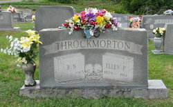
Rufus Nathaniel Throckmorton
| Birth | : | 16 Jun 1874 North Carolina, USA |
| Death | : | 13 Mar 1965 Walnut Cove, Stokes County, North Carolina, USA |
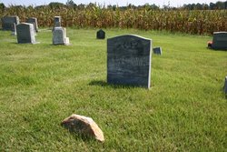
| Burial | : | St Johns Churchyard, Hororata, Selwyn District, New Zealand |
| Coordinate | : | -43.5189100, 171.9457550 |
| Description | : | Son of Julius Hade Throckmorton and Margaret Elizabeth Manring. He married Ida Priddy on 11/6/1898 in Stokes County, NC. He was the widow of Ellen Elizabeth Priddy. Cause of death: bronchopneumonia/senility. He was buried on March 15, 1965. He was a farmer. |
frequently asked questions (FAQ):
-
Where is Rufus Nathaniel Throckmorton's memorial?
Rufus Nathaniel Throckmorton's memorial is located at: St Johns Churchyard, Hororata, Selwyn District, New Zealand.
-
When did Rufus Nathaniel Throckmorton death?
Rufus Nathaniel Throckmorton death on 13 Mar 1965 in Walnut Cove, Stokes County, North Carolina, USA
-
Where are the coordinates of the Rufus Nathaniel Throckmorton's memorial?
Latitude: -43.5189100
Longitude: 171.9457550
Family Members:
Parent
Spouse
Siblings
Children
Flowers:


Nearby Cemetories:
1. St Johns Churchyard
Hororata, Selwyn District, New Zealand
Coordinate: -43.5189100, 171.9457550
2. Hororata Cemetery
Hororata, Selwyn District, New Zealand
Coordinate: -43.5196600, 171.9461100
3. South Malvern Cemetery
Glentunnel, Selwyn District, New Zealand
Coordinate: -43.4807300, 171.9475200
4. Glenroy War Memorial
Glenroy, Selwyn District, New Zealand
Coordinate: -43.5199750, 171.8345040
5. Greendale Cemetery
Greendale, Selwyn District, New Zealand
Coordinate: -43.5447560, 172.0772460
6. Trinity Church Columbarium
Darfield, Selwyn District, New Zealand
Coordinate: -43.4888350, 172.1052750
7. St Joseph's Catholic Cemetery
Darfield, Selwyn District, New Zealand
Coordinate: -43.4918030, 172.1081060
8. Rockwood Station Cemetery
Windwhistle, Selwyn District, New Zealand
Coordinate: -43.4928406, 171.7730184
9. Waddington Cemetery
Waddington, Selwyn District, New Zealand
Coordinate: -43.4001830, 172.0424870
10. Kimberley Cemetery
Darfield, Selwyn District, New Zealand
Coordinate: -43.4485800, 172.1208100
11. Barrhill Cemetery
Barrhill, Ashburton District, New Zealand
Coordinate: -43.6756950, 171.8480790
12. Kowai Pass Cemetery
Springfield, Selwyn District, New Zealand
Coordinate: -43.3399830, 171.9334560
13. Highbank Cemetery
Highbank, Ashburton District, New Zealand
Coordinate: -43.6228060, 171.7387780
14. Kirwee Cemetery
Kirwee, Selwyn District, New Zealand
Coordinate: -43.4935800, 172.2118100
15. St George's Anglican Churchyard
Kirwee, Selwyn District, New Zealand
Coordinate: -43.4940826, 172.2182446
16. Dunsandel Cemetery
Dunsandel, Selwyn District, New Zealand
Coordinate: -43.6710940, 172.1382620
17. Rakaia Cemetery
Rakaia, Ashburton District, New Zealand
Coordinate: -43.7548910, 171.9939270
18. Methven Cemetery
Methven, Ashburton District, New Zealand
Coordinate: -43.6346810, 171.6563070
19. St Matthew's Churchyard
Courtenay, Selwyn District, New Zealand
Coordinate: -43.4819060, 172.2792350
20. Halkett Presbyterian Churchyard
Halkett, Selwyn District, New Zealand
Coordinate: -43.5011000, 172.3220900
21. Brookside Cemetery
Brookside, Selwyn District, New Zealand
Coordinate: -43.6751800, 172.2683700
22. Chertsey Cemetery
Chertsey, Ashburton District, New Zealand
Coordinate: -43.8030500, 171.9319400
23. Oxford Cemetery
Oxford, Waimakariri District, New Zealand
Coordinate: -43.2976980, 172.2000500
24. Killinchy Cemetery
Leeston, Selwyn District, New Zealand
Coordinate: -43.7325610, 172.2411540