
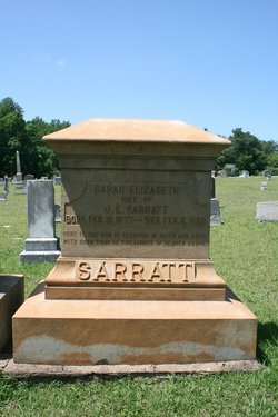

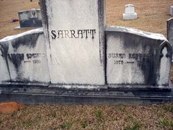
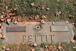
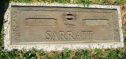
Sarah Elizabeth “Lizzie” Pettit Sarratt
| Birth | : | 18 Feb 1877 Cherokee County, South Carolina, USA |
| Death | : | 8 Feb 1920 Cherokee County, South Carolina, USA |
| Burial | : | Ellesmere Public Cemetery, Leeston, Selwyn District, New Zealand |
| Coordinate | : | -43.7775690, 172.2599220 |
frequently asked questions (FAQ):
-
Where is Sarah Elizabeth “Lizzie” Pettit Sarratt's memorial?
Sarah Elizabeth “Lizzie” Pettit Sarratt's memorial is located at: Ellesmere Public Cemetery, Leeston, Selwyn District, New Zealand.
-
When did Sarah Elizabeth “Lizzie” Pettit Sarratt death?
Sarah Elizabeth “Lizzie” Pettit Sarratt death on 8 Feb 1920 in Cherokee County, South Carolina, USA
-
Where are the coordinates of the Sarah Elizabeth “Lizzie” Pettit Sarratt's memorial?
Latitude: -43.7775690
Longitude: 172.2599220
Family Members:
Parent
Spouse
Siblings


Children


Flowers:


Nearby Cemetories:
1. Ellesmere Public Cemetery
Leeston, Selwyn District, New Zealand
Coordinate: -43.7775690, 172.2599220
2. Ellesmere Catholic Cemetery
Leeston, Selwyn District, New Zealand
Coordinate: -43.7845860, 172.2690990
3. Bishops Corner Cemetery
Southbridge, Selwyn District, New Zealand
Coordinate: -43.7824100, 172.2422900
4. St James Churchyard
Southbridge, Selwyn District, New Zealand
Coordinate: -43.8092360, 172.2502680
5. Killinchy Cemetery
Leeston, Selwyn District, New Zealand
Coordinate: -43.7325610, 172.2411540
6. Sedgemere Cemetery
Sedgemere, Selwyn District, New Zealand
Coordinate: -43.8366600, 172.3149500
7. St Luke's Anglican Churchyard
Brookside, Selwyn District, New Zealand
Coordinate: -43.6903100, 172.3029000
8. Brookside Cemetery
Brookside, Selwyn District, New Zealand
Coordinate: -43.6751800, 172.2683700
9. Hone Wetere Churchyard
Taumutu, Selwyn District, New Zealand
Coordinate: -43.8567680, 172.3586330
10. Dunsandel Cemetery
Dunsandel, Selwyn District, New Zealand
Coordinate: -43.6710940, 172.1382620
11. Dorie Cemetery
Dorie, Ashburton District, New Zealand
Coordinate: -43.8772900, 172.0862500
12. St Mary's Churchyard
Springston, Selwyn District, New Zealand
Coordinate: -43.6446560, 172.4263590
13. Kyle Cemetery
Dorie, Ashburton District, New Zealand
Coordinate: -43.9193236, 172.0979192
14. Rakaia Cemetery
Rakaia, Ashburton District, New Zealand
Coordinate: -43.7548910, 171.9939270
15. Springston Cemetery
Lincoln, Selwyn District, New Zealand
Coordinate: -43.6404360, 172.4509420
16. Lincoln Cemetery
Lincoln, Selwyn District, New Zealand
Coordinate: -43.6311790, 172.4862570
17. Weedons Cemetery
Weedons, Selwyn District, New Zealand
Coordinate: -43.5670010, 172.4015870
18. Chertsey Cemetery
Chertsey, Ashburton District, New Zealand
Coordinate: -43.8030500, 171.9319400
19. Shands Road Cemetery
Prebbleton, Selwyn District, New Zealand
Coordinate: -43.5792540, 172.4888630
20. Prebbleton Cemetery
Prebbleton, Selwyn District, New Zealand
Coordinate: -43.5887200, 172.5053500
21. St Paul's Anglican Church Cemetery
West Melton, Selwyn District, New Zealand
Coordinate: -43.5261700, 172.3701800
22. Greendale Cemetery
Greendale, Selwyn District, New Zealand
Coordinate: -43.5447560, 172.0772460
23. Church of the Epiphany Churchyard
Teddington, Christchurch City, New Zealand
Coordinate: -43.7016200, 172.6182200
24. All Saint's Churchyard
Prebbleton, Selwyn District, New Zealand
Coordinate: -43.5781040, 172.5131430