
| Birth | : | 16 Oct 1878 Wapello County, Iowa, USA |
| Death | : | 17 Mar 1942 Ottumwa, Wapello County, Iowa, USA |
| Burial | : | Vine Street Hill Cemetery, Cincinnati, Hamilton County, USA |
| Coordinate | : | 39.1516991, -84.5091019 |
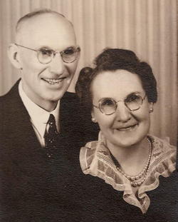
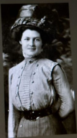
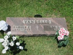
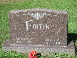
| Description | : | The following obituary Mar 19, 1942: "Mrs. Sadie Myers Dies At Age 63 Mrs. Sadie Myers, 63, wife of Earl Myers of Ottumwa route 5, died suddenly at her home at 8:30 p. m. Tuesday She was the daughter of John and Margaret Schwartz, born in Wapello county October 16, 1879. She had lived in this county all her life. She was a member of the St. Mary's Catholic church. Surviving are her husband, Earl; son, Ellsworth, Ottumwa route 5; five daughters, Mrs. Harold Vandello, Ottumwa, Mrs. Roy Bachman, Ottumwa, Mrs. Boyd Yelton, St. Louis, Mo., Mrs. Paul Lemberger, Ottumwa,... Read More |
frequently asked questions (FAQ):
-
Where is Sarah Frances “Sadie” Schwartz Myers's memorial?
Sarah Frances “Sadie” Schwartz Myers's memorial is located at: Vine Street Hill Cemetery, Cincinnati, Hamilton County, USA.
-
When did Sarah Frances “Sadie” Schwartz Myers death?
Sarah Frances “Sadie” Schwartz Myers death on 17 Mar 1942 in Ottumwa, Wapello County, Iowa, USA
-
Where are the coordinates of the Sarah Frances “Sadie” Schwartz Myers's memorial?
Latitude: 39.1516991
Longitude: -84.5091019
Family Members:
Parent

Spouse
Siblings
Children
Flowers:


Nearby Cemetories:
1. Vine Street Hill Cemetery
Cincinnati, Hamilton County, USA
Coordinate: 39.1516991, -84.5091019
2. Saint John Cemetery
Saint Bernard, Hamilton County, USA
Coordinate: 39.1643982, -84.5053024
3. Clifton United Jewish Cemetery
Cincinnati, Hamilton County, USA
Coordinate: 39.1470871, -84.5292816
4. Spring Grove Cemetery
Cincinnati, Hamilton County, USA
Coordinate: 39.1647900, -84.5231500
5. Hillside Chapel Crematory and Columbarium
Cincinnati, Hamilton County, USA
Coordinate: 39.1393509, -84.5247192
6. First German Protestant Cemetery
Avondale, Hamilton County, USA
Coordinate: 39.1492004, -84.4863968
7. Methodist Protestant Cemetery (Defunct)
Cincinnati, Hamilton County, USA
Coordinate: 39.1324770, -84.4983160
8. Saint Mary Cemetery
Saint Bernard, Hamilton County, USA
Coordinate: 39.1664009, -84.4880981
9. Walnut Hills Cemetery
Cincinnati, Hamilton County, USA
Coordinate: 39.1355950, -84.4809040
10. Walnut Hills Jewish Cemetery
Evanston, Hamilton County, USA
Coordinate: 39.1403700, -84.4731300
11. Wesleyan Cemetery
Cincinnati, Hamilton County, USA
Coordinate: 39.1599998, -84.5468979
12. Calvary Cemetery
Cincinnati, Hamilton County, USA
Coordinate: 39.1403008, -84.4697037
13. Third Quaker Cemetery (Defunct)
Cincinnati, Hamilton County, USA
Coordinate: 39.1542400, -84.5523720
14. Christ Church Cemetery
Over-The-Rhine, Hamilton County, USA
Coordinate: 39.1126480, -84.5157623
15. Second Quaker Cemetery (Defunct)
Cincinnati, Hamilton County, USA
Coordinate: 39.1153090, -84.5305240
16. Christ Episcopal Churchyard (Defunct)
Cincinnati, Hamilton County, USA
Coordinate: 39.1100520, -84.5177220
17. Potters Field
Cincinnati, Hamilton County, USA
Coordinate: 39.1094440, -84.5188890
18. Thomas Williams Cemetery (Defunct)
Cincinnati, Hamilton County, USA
Coordinate: 39.1085060, -84.5146050
19. Presbyterian Burying Ground
Cincinnati, Hamilton County, USA
Coordinate: 39.1082510, -84.5175720
20. Old Finneytown Cemetery
Finneytown, Hamilton County, USA
Coordinate: 39.1962220, -84.5206120
21. Chestnut Street Cemetery
Over-The-Rhine, Hamilton County, USA
Coordinate: 39.1071610, -84.5212210
22. Lincoln Park Potters Field (Defunct)
Cincinnati, Hamilton County, USA
Coordinate: 39.1097710, -84.5346450
23. Enon Baptist Church Burying Ground (Defunct)
Cincinnati, Hamilton County, USA
Coordinate: 39.1065420, -84.5238110
24. Catherine Street Burying Ground
Cincinnati, Hamilton County, USA
Coordinate: 39.1067490, -84.5252700