
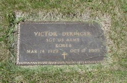
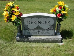
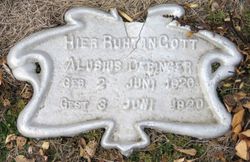
Sgt Victor Deringer
| Birth | : | 14 Mar 1929 |
| Death | : | 17 Oct 2005 Strasburg, Emmons County, North Dakota, USA |
| Burial | : | St Sebastian Churchyard, Great Gonerby, South Kesteven District, England |
| Coordinate | : | 52.9329260, -0.6657700 |
| Description | : | Name: Victor Deringer Service Info.: SGT US ARMY KOREA Birth Date: 14 Mar 1929 Death Date: 17 Oct 2005 Cemetery: St Peter & Pauls Catholic Cemetery Cemetery Address: Linton, ND 58552 Strasburg, N.D. - The funeral for Victor Deringer, 74, Strasburg, N.D., will be 10:30 a.m. Friday at St. Peter and Paul Catholic Church, Strasburg. Burial will be in the church cemetery under the direction of Myers Funeral Home, Linton. He died Monday, Oct. 17, 2005, in the Strasburg Care Center. Visitation will be noon to 9 p.m. Wednesday and 9 a.m. to 5 p.m. Thursday at... Read More |
frequently asked questions (FAQ):
-
Where is Sgt Victor Deringer's memorial?
Sgt Victor Deringer's memorial is located at: St Sebastian Churchyard, Great Gonerby, South Kesteven District, England.
-
When did Sgt Victor Deringer death?
Sgt Victor Deringer death on 17 Oct 2005 in Strasburg, Emmons County, North Dakota, USA
-
Where are the coordinates of the Sgt Victor Deringer's memorial?
Latitude: 52.9329260
Longitude: -0.6657700
Family Members:
Parent

Spouse
Siblings

Flowers:


Nearby Cemetories:
1. St Sebastian Churchyard
Great Gonerby, South Kesteven District, England
Coordinate: 52.9329260, -0.6657700
2. St John the Evangelist Churchyard
Manthorpe, South Kesteven District, England
Coordinate: 52.9306320, -0.6323160
3. Manthorpe Road Old Cemetery
Grantham, South Kesteven District, England
Coordinate: 52.9173900, -0.6409900
4. All Saints Churchyard
Barrowby, South Kesteven District, England
Coordinate: 52.9186420, -0.6946810
5. St. Wulfram Churchyard
Grantham, South Kesteven District, England
Coordinate: 52.9148180, -0.6408520
6. Grantham Cemetery and Crematorium
Grantham, South Kesteven District, England
Coordinate: 52.9095320, -0.6326120
7. St. Peter and St. Paul's Churchyard
Belton, South Kesteven District, England
Coordinate: 52.9451000, -0.6177000
8. St. Lawrence Churchyard
Sedgebrook, South Kesteven District, England
Coordinate: 52.9329460, -0.7256530
9. St Marys Churchyard
Syston, South Kesteven District, England
Coordinate: 52.9578420, -0.6172940
10. St James Churchyard
Allington, South Kesteven District, England
Coordinate: 52.9525695, -0.7245301
11. St Nicholas Churchyard
Barkston, South Kesteven District, England
Coordinate: 52.9629960, -0.6129380
12. St John the Baptist Churchyard
Londonthorpe, South Kesteven District, England
Coordinate: 52.9312060, -0.5837350
13. St Mary and St Peter Churchyard
Harlaxton, South Kesteven District, England
Coordinate: 52.8836860, -0.6895640
14. All Saints Churchyard
Hougham, South Kesteven District, England
Coordinate: 52.9878240, -0.6806910
15. St Peter Churchyard
Foston, South Kesteven District, England
Coordinate: 52.9771630, -0.7227360
16. St. Guthlac Churchyard
Little Ponton, South Kesteven District, England
Coordinate: 52.8796100, -0.6271200
17. St Andrew Churchyard
Denton, South Kesteven District, England
Coordinate: 52.8828830, -0.7151840
18. St John the Baptist Churchyard
Muston, Melton Borough, England
Coordinate: 52.9315700, -0.7680600
19. St. Wilfrid Churchyard
Honington, South Kesteven District, England
Coordinate: 52.9795600, -0.5965700
20. All Saints Churchyard
Stroxton, South Kesteven District, England
Coordinate: 52.8695300, -0.6609700
21. St James Churchyard
Woolsthorpe-by-Belvoir, South Kesteven District, England
Coordinate: 52.8957880, -0.7578370
22. All Saints Churchyard
Westborough, South Kesteven District, England
Coordinate: 52.9892900, -0.7350100
23. St. Mary Magdalene Churchyard
Old Somerby, South Kesteven District, England
Coordinate: 52.8944900, -0.5672830
24. St Swithun Churchyard
Long Bennington, South Kesteven District, England
Coordinate: 52.9856290, -0.7449190