
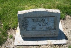
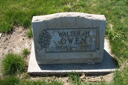
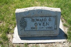
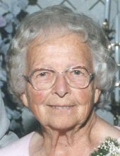
Thelma Rose Owen
| Birth | : | 27 Nov 1912 La Veta, Huerfano County, Colorado, USA |
| Death | : | 7 Feb 1980 Sterling, Logan County, Colorado, USA |
| Burial | : | St. Leonard's Churchyard, Rodney Stoke, Mendip District, England |
| Coordinate | : | 51.2455140, -2.7431800 |
| Description | : | Never married |
frequently asked questions (FAQ):
-
Where is Thelma Rose Owen's memorial?
Thelma Rose Owen's memorial is located at: St. Leonard's Churchyard, Rodney Stoke, Mendip District, England.
-
When did Thelma Rose Owen death?
Thelma Rose Owen death on 7 Feb 1980 in Sterling, Logan County, Colorado, USA
-
Where are the coordinates of the Thelma Rose Owen's memorial?
Latitude: 51.2455140
Longitude: -2.7431800
Family Members:
Parent
Siblings

Flowers:


Nearby Cemetories:
1. St. Leonard's Churchyard
Rodney Stoke, Mendip District, England
Coordinate: 51.2455140, -2.7431800
2. St. Peter's Churchyard
Draycott, Mendip District, England
Coordinate: 51.2580900, -2.7523800
3. St Lawrence Churchyard
Westbury, Mendip District, England
Coordinate: 51.2354140, -2.7182630
4. St. Andrew's Churchyard
Cheddar, Sedgemoor District, England
Coordinate: 51.2736740, -2.7761330
5. Christ Church Theale
Wedmore, Sedgemoor District, England
Coordinate: 51.2113720, -2.7631570
6. Cheddar Baptist Burial Ground
Cheddar, Sedgemoor District, England
Coordinate: 51.2767330, -2.7792010
7. Christ Church Churchyard
Henton, Mendip District, England
Coordinate: 51.2056460, -2.7256380
8. St. Mary Magdalene Churchyard Extension
Wedmore, Sedgemoor District, England
Coordinate: 51.2327583, -2.8065246
9. St. Lawrence's Churchyard
Priddy, Mendip District, England
Coordinate: 51.2596770, -2.6777600
10. St. Mary Churchyard
Wedmore, Sedgemoor District, England
Coordinate: 51.2276790, -2.8110360
11. Baptist Churchyard
Wedmore, Sedgemoor District, England
Coordinate: 51.2260400, -2.8099800
12. St. Matthew Churchyard
Wookey, Mendip District, England
Coordinate: 51.2093000, -2.6893000
13. St. Michael Sanatorium Cemetery
Axbridge, Sedgemoor District, England
Coordinate: 51.2904100, -2.8056900
14. Wells Cemetery
Wells, Mendip District, England
Coordinate: 51.2088240, -2.6640120
15. St. John the Baptist Churchyard
Axbridge, Sedgemoor District, England
Coordinate: 51.2876300, -2.8162900
16. Allerton Churchyard
Chapel Allerton, Sedgemoor District, England
Coordinate: 51.2479860, -2.8482400
17. St Gregory Churchyard
Weare, Sedgemoor District, England
Coordinate: 51.2699900, -2.8408600
18. Holy Trinity Church
Godney, Mendip District, England
Coordinate: 51.1793400, -2.7377400
19. Holy Trinity Churchyard
Blackford, Sedgemoor District, England
Coordinate: 51.2257800, -2.8483000
20. St. Cuthbert Churchyard
Wells, Mendip District, England
Coordinate: 51.2080930, -2.6502690
21. Coxley Methodist Churchyard
Coxley, Mendip District, England
Coordinate: 51.1918900, -2.6723700
22. Christ Church
Coxley, Mendip District, England
Coordinate: 51.1869530, -2.6797580
23. Wells Cathedral
Wells, Mendip District, England
Coordinate: 51.2103610, -2.6433940
24. St Thomas Churchyard
Wells, Mendip District, England
Coordinate: 51.2132380, -2.6370870