
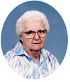

Violetta Heise Bliss
| Birth | : | 5 Oct 1916 Clarksville, Butler County, Iowa, USA |
| Death | : | 23 Oct 2008 Des Moines, Polk County, Iowa, USA |
| Burial | : | Halkett Presbyterian Churchyard, Halkett, Selwyn District, New Zealand |
| Coordinate | : | -43.5011000, 172.3220900 |
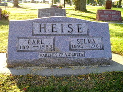
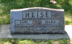
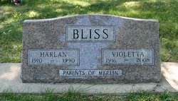
| Description | : | Violetta Bliss, 92, died Thursday, October 23, 2008 at Parkridge Nursing Home. Violetta was born on October 5, 1916 to Carl and Selma Heise in Clarksville, Iowa. Violetta was a homemaker and enjoyed playing cards and Bingo. She was also a member of the Sheridan Park United Methodist Church. Violetta is survived by her daughter-in-law, Connie Bliss; her grandson, Brad (Missy) Bliss; and two great-grandchildren, Jordan and Courtney. Violetta is preceded in death by her husband, Charles Harlan Bliss and son, Merlin Bliss. Funeral Services will be 11:00 a.m. Saturday, October 25, 2008 at Highland Memory Gardens. Friends may visit... Read More |
frequently asked questions (FAQ):
-
Where is Violetta Heise Bliss's memorial?
Violetta Heise Bliss's memorial is located at: Halkett Presbyterian Churchyard, Halkett, Selwyn District, New Zealand.
-
When did Violetta Heise Bliss death?
Violetta Heise Bliss death on 23 Oct 2008 in Des Moines, Polk County, Iowa, USA
-
Where are the coordinates of the Violetta Heise Bliss's memorial?
Latitude: -43.5011000
Longitude: 172.3220900
Family Members:
Parent
Spouse
Children

Flowers:


Nearby Cemetories:
1. St Matthew's Churchyard
Courtenay, Selwyn District, New Zealand
Coordinate: -43.4819060, 172.2792350
2. St Paul's Anglican Church Cemetery
West Melton, Selwyn District, New Zealand
Coordinate: -43.5261700, 172.3701800
3. St George's Anglican Churchyard
Kirwee, Selwyn District, New Zealand
Coordinate: -43.4940826, 172.2182446
4. Kirwee Cemetery
Kirwee, Selwyn District, New Zealand
Coordinate: -43.4935800, 172.2118100
5. Weedons Cemetery
Weedons, Selwyn District, New Zealand
Coordinate: -43.5670010, 172.4015870
6. Yaldhurst Cemetery
Yaldhurst, Christchurch City, New Zealand
Coordinate: -43.5109640, 172.4765980
7. St Saviours Churchyard
Templeton, Christchurch City, New Zealand
Coordinate: -43.5501420, 172.4714620
8. Shands Road Cemetery
Prebbleton, Selwyn District, New Zealand
Coordinate: -43.5792540, 172.4888630
9. Kimberley Cemetery
Darfield, Selwyn District, New Zealand
Coordinate: -43.4485800, 172.1208100
10. St Joseph's Catholic Cemetery
Darfield, Selwyn District, New Zealand
Coordinate: -43.4918030, 172.1081060
11. Trinity Church Columbarium
Darfield, Selwyn District, New Zealand
Coordinate: -43.4888350, 172.1052750
12. All Saint's Churchyard
Prebbleton, Selwyn District, New Zealand
Coordinate: -43.5781040, 172.5131430
13. Prebbleton Cemetery
Prebbleton, Selwyn District, New Zealand
Coordinate: -43.5887200, 172.5053500
14. St Mary's Churchyard
Springston, Selwyn District, New Zealand
Coordinate: -43.6446560, 172.4263590
15. Avonhead Memorial Cemetery
Avonhead, Christchurch City, New Zealand
Coordinate: -43.5095390, 172.5503920
16. Springston Cemetery
Lincoln, Selwyn District, New Zealand
Coordinate: -43.6404360, 172.4509420
17. St James Anglican Church
Harewood, Christchurch City, New Zealand
Coordinate: -43.4788400, 172.5579800
18. Lincoln Cemetery
Lincoln, Selwyn District, New Zealand
Coordinate: -43.6311790, 172.4862570
19. Brookside Cemetery
Brookside, Selwyn District, New Zealand
Coordinate: -43.6751800, 172.2683700
20. St Peter's Anglican Churchyard
Upper Riccarton, Christchurch City, New Zealand
Coordinate: -43.5317570, 172.5701330
21. Swannanoa Community Churchyard
Swannanoa, Waimakariri District, New Zealand
Coordinate: -43.3701500, 172.4975000
22. Greendale Cemetery
Greendale, Selwyn District, New Zealand
Coordinate: -43.5447560, 172.0772460
23. Waimairi Cemetery
Burnside, Christchurch City, New Zealand
Coordinate: -43.4997760, 172.5773860
24. Eyreton St Thomas' Anglican Cemetery
Swannanoa, Waimakariri District, New Zealand
Coordinate: -43.4153900, 172.5508800