
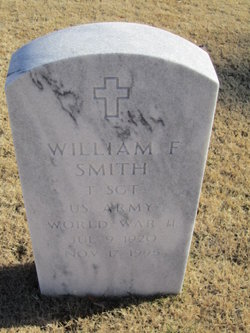
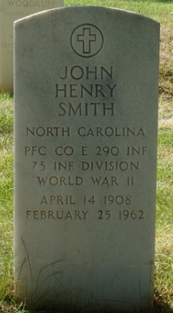
William Franklin Smith
| Birth | : | 9 Jul 1920 |
| Death | : | 17 Nov 1995 |
| Burial | : | St. Mary the Virgin Churchyard, Upleadon, Forest of Dean District, England |
| Coordinate | : | 51.9406240, -2.3378190 |
| Plot | : | I, 0, 398 |
frequently asked questions (FAQ):
-
Where is William Franklin Smith's memorial?
William Franklin Smith's memorial is located at: St. Mary the Virgin Churchyard, Upleadon, Forest of Dean District, England.
-
When did William Franklin Smith death?
William Franklin Smith death on 17 Nov 1995 in
-
Where are the coordinates of the William Franklin Smith's memorial?
Latitude: 51.9406240
Longitude: -2.3378190
Family Members:
Parent
Spouse
Siblings

Flowers:


Nearby Cemetories:
1. St. Mary the Virgin Churchyard
Upleadon, Forest of Dean District, England
Coordinate: 51.9406240, -2.3378190
2. St. John the Evangelist Churchyard
Pauntley, Forest of Dean District, England
Coordinate: 51.9588610, -2.3670030
3. St. Mary the Virgin Churchyard
Hartpury, Forest of Dean District, England
Coordinate: 51.9110277, -2.3204027
4. Hartpury Methodist Churchyard
Hartpury, Forest of Dean District, England
Coordinate: 51.9196444, -2.2883000
5. St. Bartholomew's Churchyard
Redmarley, Forest of Dean District, England
Coordinate: 51.9795670, -2.3622700
6. St. Mary the Virgin Cemetery
Rudford, Forest of Dean District, England
Coordinate: 51.8936272, -2.3213976
7. Newent Cemetery
Newent, Forest of Dean District, England
Coordinate: 51.9272500, -2.4135730
8. St Anne's Churchyard
Oxenhall, Forest of Dean District, England
Coordinate: 51.9383000, -2.4212000
9. St. Oswald Churchyard
Lassington, Tewkesbury Borough, England
Coordinate: 51.8884700, -2.2978000
10. St. Giles Churchyard
Maisemore, Tewkesbury Borough, England
Coordinate: 51.8931690, -2.2719540
11. St Lawrence Churchyard
Sandhurst, Tewkesbury Borough, England
Coordinate: 51.9083260, -2.2489570
12. St Mary the Virgin Churchyard
Bromsberrow, Forest of Dean District, England
Coordinate: 52.0008740, -2.3768560
13. St. Michael and All Angels Churchyard
Tirley, Tewkesbury Borough, England
Coordinate: 51.9552600, -2.2341600
14. St Faith Churchyard
Berrow, Malvern Hills District, England
Coordinate: 52.0065770, -2.3018720
15. Holy Innocents Churchyard
Highnam, Tewkesbury Borough, England
Coordinate: 51.8740890, -2.2970050
16. St Mary's Churchyard
Dymock, Forest of Dean District, England
Coordinate: 51.9793264, -2.4376889
17. Christ Church Churchyard
Gorsley, Forest of Dean District, England
Coordinate: 51.9291294, -2.4559924
18. Pendock Old Church
Pendock, Malvern Hills District, England
Coordinate: 52.0014720, -2.2679110
19. Pendock Churchyard
Pendock, Malvern Hills District, England
Coordinate: 52.0015108, -2.2678653
20. St. Andrew's Churchyard
Churcham, Forest of Dean District, England
Coordinate: 51.8618970, -2.3375000
21. St. Matthew's Cemetery
Twigworth, Tewkesbury Borough, England
Coordinate: 51.8936090, -2.2307820
22. St John the Baptist Churchyard
Huntley, Forest of Dean District, England
Coordinate: 51.8712980, -2.4068210
23. St. Peter and St. Paul Churchyard
Birtsmorton, Malvern Hills District, England
Coordinate: 52.0176100, -2.2912600
24. Holy Trinity Churchyard
Apperley, Tewkesbury Borough, England
Coordinate: 51.9510043, -2.2029317