
| Memorials | : | 45 |
| Location | : | Lassington, Tewkesbury Borough, England |
| Coordinate | : | 51.8884700, -2.2978000 |
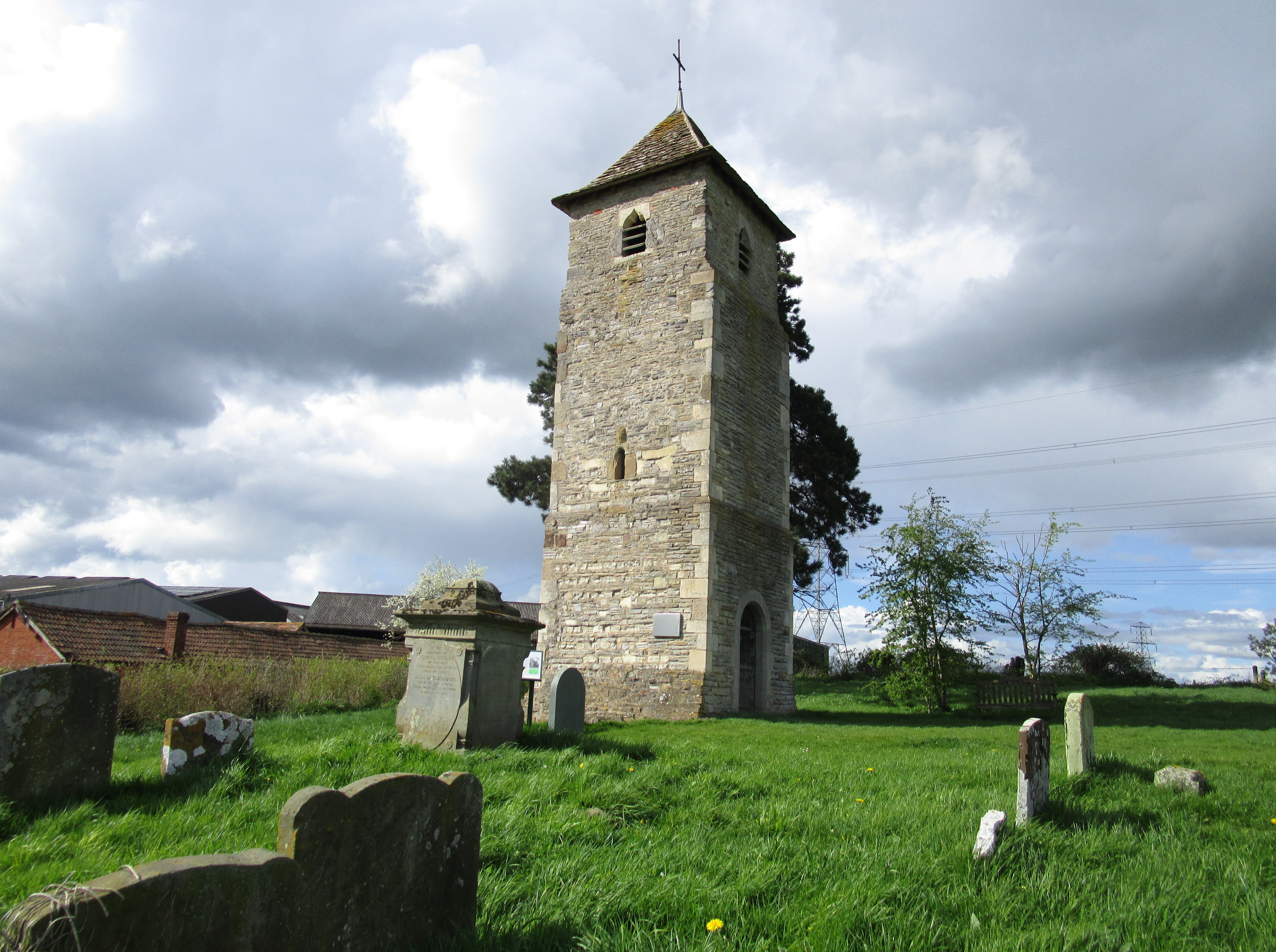
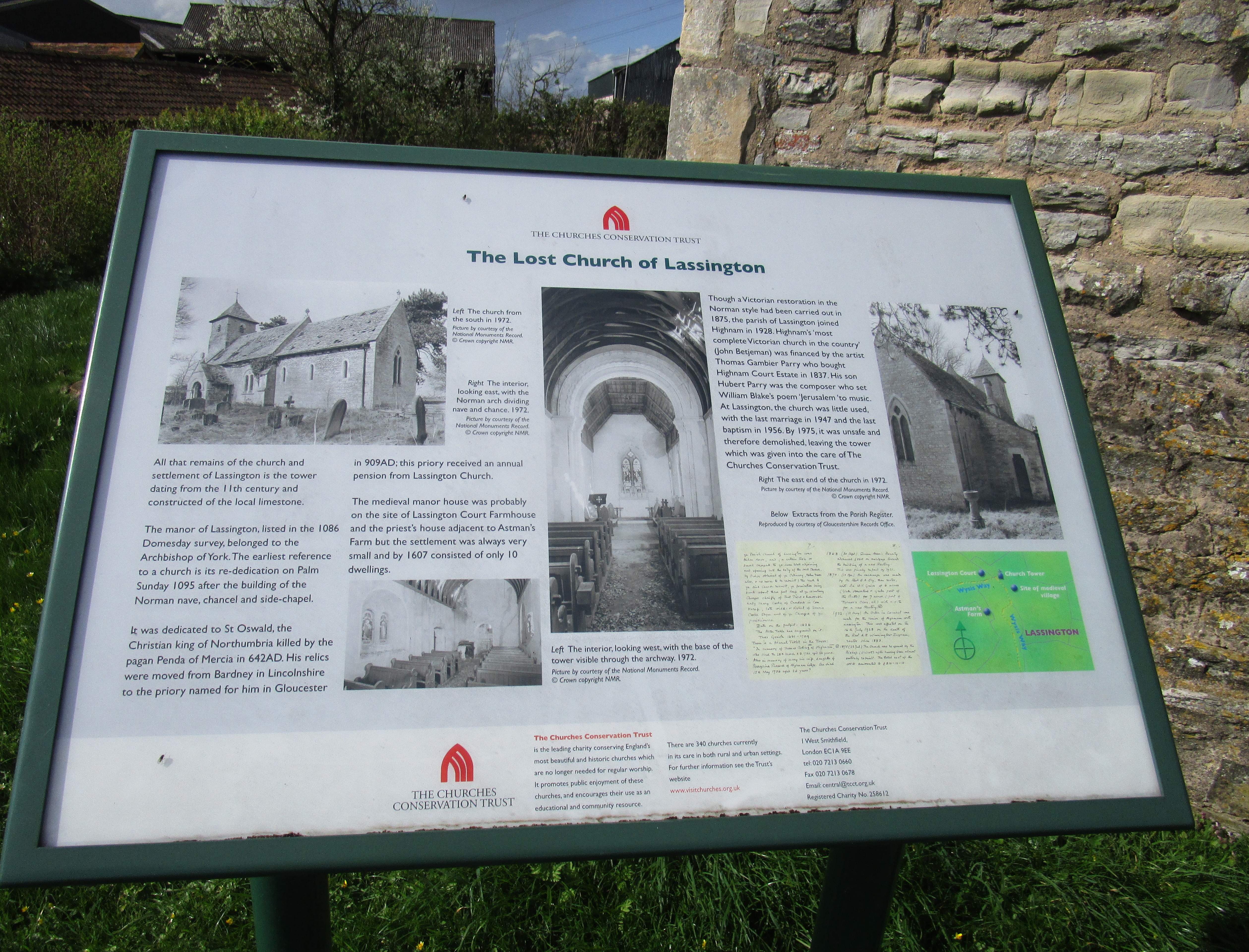
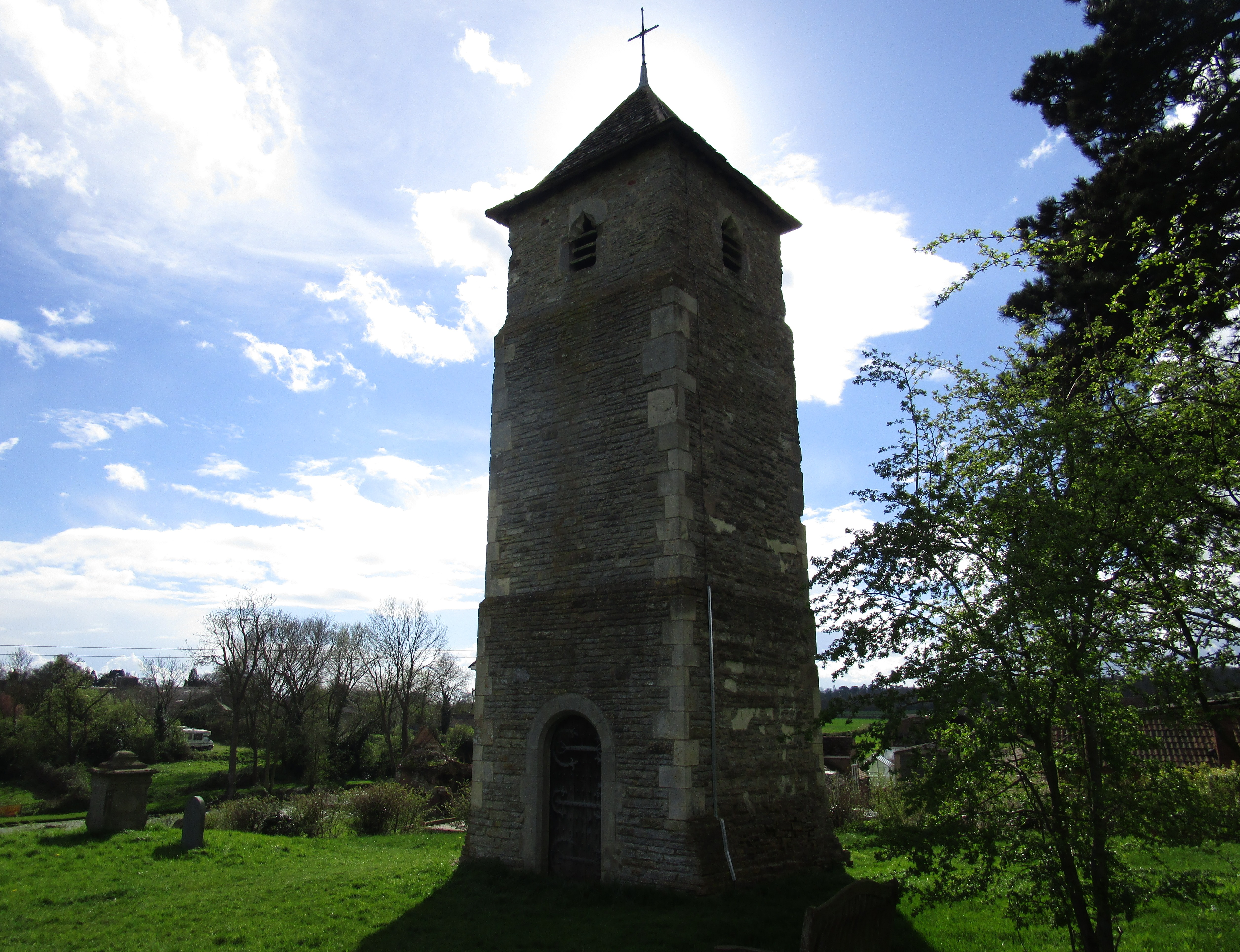
| Description | : | St Oswald's Church [dedicated in 1095]is a redundant Anglican church in the village of Lassington and the civil parish of Highnam, Gloucestershire, England. Only its tower now survives. The tower is recorded in the National Heritage List for England as a designated Grade II listed building, and is under the care of the Churches Conservation Trust. [vested 6 September 1974 ] Construction of the tower began in the late 11th century. The church was initially a chapel of St Oswald's Priory in Gloucester. The nave and south porch of the church were in Norman style, and the chancel was Early English.... Read More |
frequently asked questions (FAQ):
-
Where is St. Oswald Churchyard?
St. Oswald Churchyard is located at Lassington Lane Lassington, Tewkesbury Borough ,Gloucestershire , GL2 8DHEngland.
-
St. Oswald Churchyard cemetery's updated grave count on graveviews.com?
45 memorials
-
Where are the coordinates of the St. Oswald Churchyard?
Latitude: 51.8884700
Longitude: -2.2978000

Nearby Cemetories:
1. Holy Innocents Churchyard
Highnam, Tewkesbury Borough, England
Coordinate: 51.8740890, -2.2970050
2. St. Mary the Virgin Cemetery
Rudford, Forest of Dean District, England
Coordinate: 51.8936272, -2.3213976
3. St. Giles Churchyard
Maisemore, Tewkesbury Borough, England
Coordinate: 51.8931690, -2.2719540
4. St. Mary the Virgin Churchyard
Hartpury, Forest of Dean District, England
Coordinate: 51.9110277, -2.3204027
5. Hartpury Methodist Churchyard
Hartpury, Forest of Dean District, England
Coordinate: 51.9196444, -2.2883000
6. St Lawrence Churchyard
Sandhurst, Tewkesbury Borough, England
Coordinate: 51.9083260, -2.2489570
7. St. Andrew's Churchyard
Churcham, Forest of Dean District, England
Coordinate: 51.8618970, -2.3375000
8. Saint Oswald's Priory
Gloucester, City of Gloucester, England
Coordinate: 51.8694000, -2.2478000
9. St Nicholas' Church
Gloucester, City of Gloucester, England
Coordinate: 51.8672800, -2.2496760
10. Llanthony Secunda Priory
Hempsted, City of Gloucester, England
Coordinate: 51.8602130, -2.2572640
11. Gloucester Cathedral
Gloucester, City of Gloucester, England
Coordinate: 51.8675920, -2.2467670
12. St. Swithun's Churchyard
Hempsted, City of Gloucester, England
Coordinate: 51.8515740, -2.2719420
13. St. Matthew's Cemetery
Twigworth, Tewkesbury Borough, England
Coordinate: 51.8936090, -2.2307820
14. St. Peter's Churchyard
Minsterworth, Tewkesbury Borough, England
Coordinate: 51.8511500, -2.3307800
15. St Margaret's Chapel
Gloucester, City of Gloucester, England
Coordinate: 51.8686720, -2.2321530
16. Chapel of St Mary Magdalen
Gloucester, City of Gloucester, England
Coordinate: 51.8693000, -2.2291000
17. Saint Catharine's
Gloucester, City of Gloucester, England
Coordinate: 51.8691700, -2.2273500
18. Horton Road Cemetery
Gloucester, City of Gloucester, England
Coordinate: 51.8666900, -2.2268300
19. St. Mary the Virgin Churchyard
Upleadon, Forest of Dean District, England
Coordinate: 51.9406240, -2.3378190
20. Gloucester Crematorium
Gloucester, City of Gloucester, England
Coordinate: 51.8538180, -2.2219260
21. Gloucester Old Cemetery
Gloucester, City of Gloucester, England
Coordinate: 51.8482100, -2.2276700
22. St. James' Churchyard
Quedgeley, City of Gloucester, England
Coordinate: 51.8257770, -2.2811150
23. St Lawrence Churchyard
Barnwood, City of Gloucester, England
Coordinate: 51.8580470, -2.2069750
24. St John the Baptist Churchyard
Huntley, Forest of Dean District, England
Coordinate: 51.8712980, -2.4068210