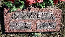
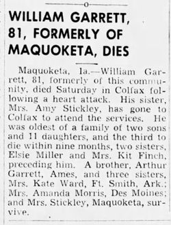
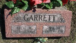
William H Garrett
| Birth | : | 1869 |
| Death | : | 1951 |
| Burial | : | Newcastle St. Illtyd Churchyard, Wales |
| Coordinate | : | 51.5080900, -3.5829600 |
| Plot | : | Block 4 Row 6 |
frequently asked questions (FAQ):
-
Where is William H Garrett's memorial?
William H Garrett's memorial is located at: Newcastle St. Illtyd Churchyard, Wales.
-
When did William H Garrett death?
William H Garrett death on 1951 in
-
Where are the coordinates of the William H Garrett's memorial?
Latitude: 51.5080900
Longitude: -3.5829600
Family Members:
Parent
Spouse
Siblings
Children
Flowers:
Nearby Cemetories:
1. Newcastle St. Illtyd Churchyard
Wales
Coordinate: 51.5080900, -3.5829600
2. Holy Trinity Churchyard
Ilfracombe, North Devon District, England
Coordinate: 51.5571712, -3.5946496
3. Penrhys Cemetery
Wales
Coordinate: 51.6420500, -3.4425800
4. St Nicholas Church
Wales
Coordinate: 51.4605000, -3.3098000
5. St George's Churchyard
Wales
Coordinate: 51.4819300, -3.2911700
6. Twyn yr Odyn Baptist Chapel Burial Ground
Wales
Coordinate: 51.4563708, -3.2739268
7. Alltwen Welsh Congregational Chapelyard
Wales
Coordinate: 51.7139600, -3.8444700
8. Godre'r Graig Independent Chapel Cemetery
Wales
Coordinate: 51.7474400, -3.8089300
9. Rhyd-Y-Fro Saron Congregational Old Chapelyard
Wales
Coordinate: 51.7379400, -3.8662700
10. Culbone St. Bueno's Churchyard
Oare, West Somerset District, England
Coordinate: 51.2213640, -3.6594820
11. St David Church Burial Ground
Wales
Coordinate: 51.7703100, -3.7884600
12. All Saints Churchyard
Selworthy, West Somerset District, England
Coordinate: 51.2101800, -3.5475440
13. Selworthy Extension Cemeteries
Selworthy, West Somerset District, England
Coordinate: 51.2098330, -3.5481240
14. St Dubricius Churchyard
Porlock, West Somerset District, England
Coordinate: 51.2083000, -3.5955000
15. Saint David's Churchyard
Wales
Coordinate: 51.8017440, -3.6967650
16. St. Michael's Anglican Church Cemetery
Minehead, West Somerset District, England
Coordinate: 51.2110390, -3.4808250
17. Porlock Cemetery
Porlock, West Somerset District, England
Coordinate: 51.2033790, -3.5954070
18. St. Mary the Virgin Churchyard
Oare, West Somerset District, England
Coordinate: 51.2124350, -3.7164290
19. Minehead Cemetery
Minehead, West Somerset District, England
Coordinate: 51.2050650, -3.4982030
20. Luccombe Extension Cemetery
Luccombe, West Somerset District, England
Coordinate: 51.1897360, -3.5609100
21. St. Mary's Churchyard
Luccombe, West Somerset District, England
Coordinate: 51.1895770, -3.5596880
22. St. Mary the Virgin Churchyard
Lynton, North Devon District, England
Coordinate: 51.2298700, -3.8339800
23. St. Brendon's Churchyard
Brendon, North Devon District, England
Coordinate: 51.2149390, -3.7910490
24. Three Crosses Churchyard, Capel y Crwys
Wales
Coordinate: 51.6278387, -4.0653017

