William Humphrey Dedrick
| Birth | : | 22 Jan 1840 Pennsylvania, USA |
| Death | : | 12 Nov 1901 |
| Burial | : | Witton Cemetery, Witton, Metropolitan Borough of Birmingham, England |
| Coordinate | : | 52.5265230, -1.8827870 |
| Plot | : | Block 4 Lot 20 |
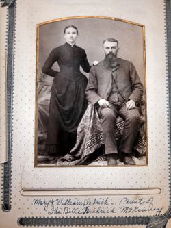
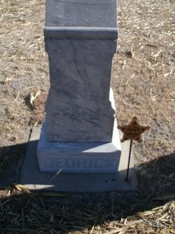
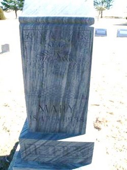
| Description | : | William H. Dedrick was born in Fayette County, Pennsylvania, Jan 22, 1840, died November 12, 1901; volunteered in Co L Second Ohio Cavalry, on February 22, 1864 and served in the defense of the country and flag he loved so dearly until the close of the war. Deceased and Miss Mary Walker were married September 15, 1864, and to this union were born five children, of whom four survive him, a son and three daughters. Mr. Dedrick and family moved to Sheridan county, Kansas in March 1887, since that time they have been the best of citizens and his death... Read More |
frequently asked questions (FAQ):
-
Where is William Humphrey Dedrick's memorial?
William Humphrey Dedrick's memorial is located at: Witton Cemetery, Witton, Metropolitan Borough of Birmingham, England.
-
When did William Humphrey Dedrick death?
William Humphrey Dedrick death on 12 Nov 1901 in
-
Where are the coordinates of the William Humphrey Dedrick's memorial?
Latitude: 52.5265230
Longitude: -1.8827870
Family Members:
Parent
Spouse
Siblings
Children
Flowers:
Nearby Cemetories:
1. Witton Cemetery
Witton, Metropolitan Borough of Birmingham, England
Coordinate: 52.5265230, -1.8827870
2. Witton Jewish Cemetery
Birmingham, Metropolitan Borough of Birmingham, England
Coordinate: 52.5342500, -1.8808700
3. St John the Evangelist Churchyard
Perry Barr, Metropolitan Borough of Birmingham, England
Coordinate: 52.5260757, -1.9005234
4. Birmingham Crematorium
Birmingham, Metropolitan Borough of Birmingham, England
Coordinate: 52.5288170, -1.9094020
5. St Peter and St Paul Churchyard
Aston, Metropolitan Borough of Birmingham, England
Coordinate: 52.5070340, -1.8796590
6. Oscott College Cemetery
Sutton Coldfield, Metropolitan Borough of Birmingham, England
Coordinate: 52.5406600, -1.8512000
7. St. Barnabas Churchyard
Erdington, Metropolitan Borough of Birmingham, England
Coordinate: 52.5225500, -1.8392400
8. St. Mary's Churchyard
Handsworth, Metropolitan Borough of Birmingham, England
Coordinate: 52.5106700, -1.9193690
9. Erdington Greek Orthodox Churchyard
Erdington, Metropolitan Borough of Birmingham, England
Coordinate: 52.5267800, -1.8369700
10. St Josephs Churchyard
Nechells, Metropolitan Borough of Birmingham, England
Coordinate: 52.4989600, -1.8710100
11. St Thomas of Canterbury
Erdington, Metropolitan Borough of Birmingham, England
Coordinate: 52.5283500, -1.8356200
12. St. Michael's Churchyard
Boldmere, Metropolitan Borough of Birmingham, England
Coordinate: 52.5421250, -1.8393150
13. St. Matthews Churchyard
Duddeston, Metropolitan Borough of Birmingham, England
Coordinate: 52.4905400, -1.8775100
14. St. James the Less Churchyard
Birmingham, Metropolitan Borough of Birmingham, England
Coordinate: 52.4867050, -1.8797570
15. Key Hill Cemetery
Birmingham, Metropolitan Borough of Birmingham, England
Coordinate: 52.4908400, -1.9158600
16. St. Saviour Churchyard
Saltley, Metropolitan Borough of Birmingham, England
Coordinate: 52.4872100, -1.8579400
17. Saint Marys Chapel (Defunct)
Birmingham, Metropolitan Borough of Birmingham, England
Coordinate: 52.4850600, -1.8961600
18. All Saints Churchyard
Hockley, Metropolitan Borough of Birmingham, England
Coordinate: 52.4915890, -1.9218570
19. St. Margaret's Churchyard
Ward End, Metropolitan Borough of Birmingham, England
Coordinate: 52.4953100, -1.8341300
20. Warstone Lane Cemetery
Birmingham, Metropolitan Borough of Birmingham, England
Coordinate: 52.4874340, -1.9139250
21. St. Paul's Churchyard
Birmingham, Metropolitan Borough of Birmingham, England
Coordinate: 52.4852472, -1.9057710
22. Handsworth Cemetery
Handsworth, Metropolitan Borough of Birmingham, England
Coordinate: 52.5160120, -1.9531440
23. St. Margaret's Churchyard
Great Barr, Metropolitan Borough of Birmingham, England
Coordinate: 52.5607000, -1.9295700
24. Old Quaker Burial Ground
Birmingham, Metropolitan Borough of Birmingham, England
Coordinate: 52.4823770, -1.8960750

