

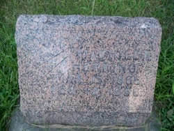
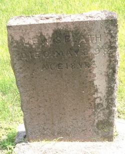
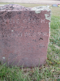
William “Willie” Plath
| Birth | : | Dec 1881 Platte County, Nebraska, USA |
| Death | : | 4 Jan 1892 Platte County, Nebraska, USA |
| Burial | : | Saint Luke Churchyard, Duston, Northampton Borough, England |
| Coordinate | : | 52.2428820, -0.9396550 |
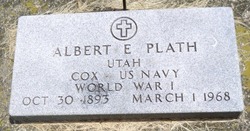
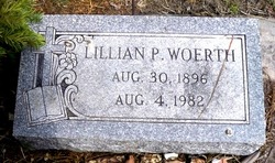
| Description | : | William "Willie" Eighth child of Nine, fourth born son of Four of William E. and Matilda (Gottberg) Plath. Brother of Lewis, Bertha (Godberson), George, Oillie, Albert, Lillian (Woerth), Matilda (Hoshor) and Elizabeth Plath. _________________ Thank you to Contributor # 47466150 for the following information: The Columbus Journal, January 20, 1892 PLATH; LUSCHEN--Two children were buried in the Lutheran cemetery this week. The son of Wm. Plath of Humphrey, age 10 years, and the only daughter of Gerhart Luschen of Sherman twp., age 3 years. [Grand Prairie.] & "William/Wilhelm Platt, died Jan 4, 1892, age 10 years, 11 days, Children of Wm." Notes from "Platte County Nebraska Cemetery Book:... Read More |
frequently asked questions (FAQ):
-
Where is William “Willie” Plath's memorial?
William “Willie” Plath's memorial is located at: Saint Luke Churchyard, Duston, Northampton Borough, England.
-
When did William “Willie” Plath death?
William “Willie” Plath death on 4 Jan 1892 in Platte County, Nebraska, USA
-
Where are the coordinates of the William “Willie” Plath's memorial?
Latitude: 52.2428820
Longitude: -0.9396550
Family Members:
Parent

Siblings

Flowers:


Nearby Cemetories:
1. Saint Luke Churchyard
Duston, Northampton Borough, England
Coordinate: 52.2428820, -0.9396550
2. St Michael's Churchyard
Upton, Northampton Borough, England
Coordinate: 52.2356600, -0.9508160
3. Dallington Cemetery
Northampton, Northampton Borough, England
Coordinate: 52.2505200, -0.9287200
4. St. Sepulchre Churchyard
Northampton, Northampton Borough, England
Coordinate: 52.2414600, -0.8973600
5. All Saints Church
Northampton, Northampton Borough, England
Coordinate: 52.2371129, -0.8964385
6. St. Luke Churchyard
Kislingbury, South Northamptonshire Borough, England
Coordinate: 52.2307300, -0.9806300
7. Northampton Gaol Cemetery
Northampton, Northampton Borough, England
Coordinate: 52.2418540, -0.8940440
8. Northampton County Goal Cemetery
Northampton, Northampton Borough, England
Coordinate: 52.2364470, -0.8945440
9. Cemetery of the Sisters of Notre Dame
Northampton Borough, England
Coordinate: 52.2399000, -0.8923333
10. Towcester Road Cemetery
Far Cotton, Northampton Borough, England
Coordinate: 52.2178190, -0.9117050
11. All Saints Churchyard
Harpole, South Northamptonshire Borough, England
Coordinate: 52.2427100, -0.9899750
12. Counties Crematorium
Northampton, Northampton Borough, England
Coordinate: 52.2058720, -0.9245220
13. Kingsthorpe Cemetery
Kingsthorpe, Northampton Borough, England
Coordinate: 52.2740400, -0.9001200
14. Billing Road Cemetery
Northampton, Northampton Borough, England
Coordinate: 52.2387200, -0.8750900
15. Rothersthorpe Extension
Rothersthorpe, South Northamptonshire Borough, England
Coordinate: 52.2046235, -0.9591382
16. St Peter and St Paul
Rothersthorpe, South Northamptonshire Borough, England
Coordinate: 52.2034651, -0.9566385
17. St Botolph Churchyard
Church Brampton, Daventry District, England
Coordinate: 52.2849866, -0.9486724
18. St Peter and St Paul Churchyard
Abington, Northampton Borough, England
Coordinate: 52.2461580, -0.8653790
19. Hardingstone Combined War Memorial
Hardingstone, Northampton Borough, England
Coordinate: 52.2137600, -0.8784700
20. St John the Baptist Churchyard
Boughton, Daventry District, England
Coordinate: 52.2861187, -0.8971496
21. Spencer Estate Grounds
Althorp, Daventry District, England
Coordinate: 52.2839190, -0.9889520
22. Old St John the Baptist Churchyard
Boughton, Daventry District, England
Coordinate: 52.2836464, -0.8801961
23. Weston Favel Cemetery
Weston Favell, Northampton Borough, England
Coordinate: 52.2492980, -0.8483410
24. St Michael & All Angels Churchyard
Bugbrooke, South Northamptonshire Borough, England
Coordinate: 52.2096900, -1.0149000