
| Memorials | : | 0 |
| Location | : | Wareham, Purbeck District, England |
| Coordinate | : | 50.6888000, -2.1115000 |
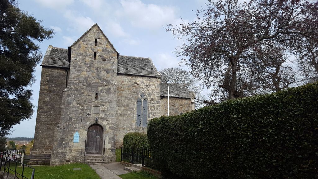
| Description | : | St Martin-on-the-Walls (also known as St Martins Church) is the only 1000 year old Saxon church in Dorset which survives close to its original state. The altar takes up most of the church. The simple tall, narrow nave as well as a tiny window in the north side of the chancel are original, dating back to 1030. In the northwest aisle is Saxon wall-arcading and traces of a Saxon door. There are 12th century frescoes on the North wall of the chancel which depict St Martin on horseback, escorted by attendants, dividing his cloak and giving one half to a... Read More |
frequently asked questions (FAQ):
-
Where is St Martin-on-the-Walls?
St Martin-on-the-Walls is located at Wareham, Purbeck District ,Dorset ,England.
-
St Martin-on-the-Walls cemetery's updated grave count on graveviews.com?
0 memorials
-
Where are the coordinates of the St Martin-on-the-Walls?
Latitude: 50.6888000
Longitude: -2.1115000
Nearby Cemetories:
1. United Reformed Churchyard
Wareham, Purbeck District, England
Coordinate: 50.6860338, -2.1078591
2. Wareham Cemetery
Wareham, Purbeck District, England
Coordinate: 50.6848600, -2.1066320
3. Lady St Mary Churchyard
Wareham, Purbeck District, England
Coordinate: 50.6843130, -2.1077420
4. Hill View Cemetery
Wareham, Purbeck District, England
Coordinate: 50.6828550, -2.1266310
5. St. John the Evangelist
East Holme, Purbeck District, England
Coordinate: 50.6730910, -2.1440880
6. St. Mary's Churchyard
East Stoke, Purbeck District, England
Coordinate: 50.6830000, -2.1818000
7. St Peter's Churchyard Church Knowle
Church Knowle, Purbeck District, England
Coordinate: 50.6370800, -2.0851140
8. Lytchett Minster United Reformed Church
Lytchett Minster, Purbeck District, England
Coordinate: 50.7346300, -2.0622130
9. Lytchett Minster Parish Churchyard
Lytchett Minster, Purbeck District, England
Coordinate: 50.7372870, -2.0573970
10. St Edward King and Martyr
Corfe Castle, Purbeck District, England
Coordinate: 50.6383980, -2.0573030
11. St. Michael's and All Angels Churchyard
Steeple, Purbeck District, England
Coordinate: 50.6277090, -2.1267040
12. God's Acre Cemetery
Corfe Castle, Purbeck District, England
Coordinate: 50.6366100, -2.0591320
13. Bindon Abbey Graveyard
Wool, Purbeck District, England
Coordinate: 50.6802430, -2.2097550
14. Old Church Cemetery
Corfe Castle, Purbeck District, England
Coordinate: 50.6367499, -2.0549142
15. Monkey World
Bovington Camp, Purbeck District, England
Coordinate: 50.6994813, -2.2169029
16. Holy Rood Churchyard
Wool, Purbeck District, England
Coordinate: 50.6774970, -2.2169630
17. Kimmeridge Churchyard
Kimmeridge, Purbeck District, England
Coordinate: 50.6192291, -2.1187155
18. St Mary's Church
East Morden, Purbeck District, England
Coordinate: 50.7597770, -2.1200990
19. St. Michael's Churchyard
Hamworthy, Poole Unitary Authority, England
Coordinate: 50.7199660, -2.0099190
20. Upton Cemetery
Upton, Purbeck District, England
Coordinate: 50.7436900, -2.0348970
21. St. Andrew's Churchyard
Bloxworth, Purbeck District, England
Coordinate: 50.7518333, -2.1706073
22. St Mary's Churchyard
Tyneham, Purbeck District, England
Coordinate: 50.6230090, -2.1689980
23. Harbour View Woodland Burial Ground
Lytchett Minster, Purbeck District, England
Coordinate: 50.7507040, -2.0434430
24. St James Churchyard
Kingston, Purbeck District, England
Coordinate: 50.6156390, -2.0641100