
| Memorials | : | 0 |
| Location | : | Raleigh, Smith County, USA |
| Coordinate | : | 32.0985177, -89.5898151 |
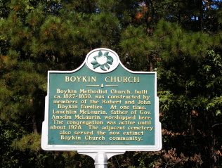
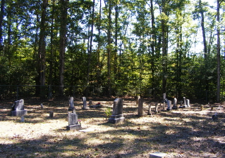
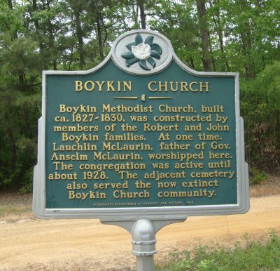
| Description | : | From Raleigh Mississippi take Highway 18 West approximately 3.5 miles to the intersection of road 539. Turn right (North) on 539 and proceed 3.6 mile to the intersection of US Forrest Service Road 503 (FSR 503) also known as Boykin Church Road, and turn left (West.) Proceed for one mile, rebuilt church and cemetery will be on the left (South,) specifically: NW1/4 SW1/4, S16, T3N-R7E, Smith, Raleigh Quadrangle map, 16S BA 55603 54291. |
frequently asked questions (FAQ):
-
Where is Boykin Church Cemetery?
Boykin Church Cemetery is located at Boykin Church Road Raleigh, Smith County ,Mississippi , 39153USA.
-
Boykin Church Cemetery cemetery's updated grave count on graveviews.com?
0 memorials
-
Where are the coordinates of the Boykin Church Cemetery?
Latitude: 32.0985177
Longitude: -89.5898151
Nearby Cemetories:
1. Gordan Cemetery
Raleigh, Smith County, USA
Coordinate: 32.0950012, -89.5935974
2. Moss Cemetery
Smith County, USA
Coordinate: 32.1063995, -89.5919037
3. Myers Cemetery
Raleigh, Smith County, USA
Coordinate: 32.0950012, -89.5730972
4. Sharon Baptist Church Cemetery
Raleigh, Smith County, USA
Coordinate: 32.0909100, -89.5740800
5. Moulder Cemetery
Smith County, USA
Coordinate: 32.1239014, -89.6007996
6. Steve Hughes Cemetery
Smith County, USA
Coordinate: 32.1073600, -89.6344000
7. Page Cemetery
Raleigh, Smith County, USA
Coordinate: 32.0891991, -89.5432968
8. Craft Cemetery
Smith County, USA
Coordinate: 32.0774994, -89.5460968
9. Providence Cemetery
Burns, Smith County, USA
Coordinate: 32.1357400, -89.5528600
10. Derrick Cemetery
Smith County, USA
Coordinate: 32.1484800, -89.5742400
11. Burns United Methodist Church Cemetery
Burns, Smith County, USA
Coordinate: 32.1310501, -89.5399399
12. Sardis Baptist Cemetery
Smith County, USA
Coordinate: 32.1202100, -89.6486300
13. Barber Cemetery
Raleigh, Smith County, USA
Coordinate: 32.1321810, -89.5385960
14. Burns Baptist Church Cemetery
Raleigh, Smith County, USA
Coordinate: 32.1321880, -89.5384430
15. Austin Cemetery
Shongelo, Smith County, USA
Coordinate: 32.0875015, -89.5233002
16. Henderson Family Cemetery
Smith County, USA
Coordinate: 32.1207008, -89.5181122
17. Mount Pisgah Cemetery
Raleigh, Smith County, USA
Coordinate: 32.0589300, -89.5261100
18. Barnes Cemetery
Raleigh, Smith County, USA
Coordinate: 32.0946999, -89.5068970
19. Zion Cemetery
Smith County, USA
Coordinate: 32.1689700, -89.5918000
20. New Chapel Cemetery
Smith County, USA
Coordinate: 32.1710100, -89.5944800
21. Corinth Baptist Church Cemetery
Raleigh, Smith County, USA
Coordinate: 32.0265100, -89.5593900
22. Crossroads Holiness Church Cemetery
Raleigh, Smith County, USA
Coordinate: 32.0237000, -89.6119300
23. Good Hope Cemetery
Smith County, USA
Coordinate: 32.1613100, -89.5345100
24. Terry Cemetery
Raleigh, Smith County, USA
Coordinate: 32.0918800, -89.6831100