
| Memorials | : | 1 |
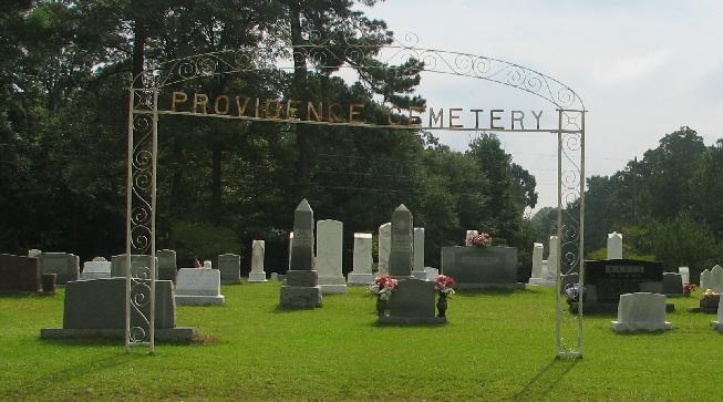
| Location | : | Burns, Smith County, USA |
| Coordinate | : | 32.1357400, -89.5528600 |
| Description | : | From Raleigh, MS proceed North on Mississippi Highway 35 (MS 35 aka Mimosa Drive) 6.4 miles to the intersection of Mississippi Highway 481 (MS 481.) Turn Left (West) on MS 481 and continue 2.4 miles to the intersection of Smith County Road 539 (SCR 539.) Turn Left (Southwest onto SCR 539 and follow road around cemetery to parking lot, specifically SE1/4 SW1/4, S35, T4N-R7E, Smith, Homewood Quadrangle map, USNG 16S BA 59189 58336. |
frequently asked questions (FAQ):
-
Where is Providence Cemetery?
Providence Cemetery is located at Mississippi Highway 481 Burns, Smith County ,Mississippi , 39152USA.
-
Providence Cemetery cemetery's updated grave count on graveviews.com?
1 memorials
-
Where are the coordinates of the Providence Cemetery?
Latitude: 32.1357400
Longitude: -89.5528600

Nearby Cemetories:
1. Burns United Methodist Church Cemetery
Burns, Smith County, USA
Coordinate: 32.1310501, -89.5399399
2. Barber Cemetery
Raleigh, Smith County, USA
Coordinate: 32.1321810, -89.5385960
3. Burns Baptist Church Cemetery
Raleigh, Smith County, USA
Coordinate: 32.1321880, -89.5384430
4. Derrick Cemetery
Smith County, USA
Coordinate: 32.1484800, -89.5742400
5. Good Hope Cemetery
Smith County, USA
Coordinate: 32.1613100, -89.5345100
6. Henderson Family Cemetery
Smith County, USA
Coordinate: 32.1207008, -89.5181122
7. Moulder Cemetery
Smith County, USA
Coordinate: 32.1239014, -89.6007996
8. Goodwater Baptist Church Cemetery
Smith County, USA
Coordinate: 32.1415200, -89.5027900
9. Myers Cemetery
Raleigh, Smith County, USA
Coordinate: 32.0950012, -89.5730972
10. Moss Cemetery
Smith County, USA
Coordinate: 32.1063995, -89.5919037
11. Zion Cemetery
Smith County, USA
Coordinate: 32.1689700, -89.5918000
12. Page Cemetery
Raleigh, Smith County, USA
Coordinate: 32.0891991, -89.5432968
13. Bethel Baptist Church Cemetery
Smith County, USA
Coordinate: 32.1830920, -89.5565660
14. Gasque Chapel Cemetery
Smith County, USA
Coordinate: 32.1793540, -89.5297340
15. Sharon Baptist Church Cemetery
Raleigh, Smith County, USA
Coordinate: 32.0909100, -89.5740800
16. Boykin Church Cemetery
Raleigh, Smith County, USA
Coordinate: 32.0985177, -89.5898151
17. New Chapel Cemetery
Smith County, USA
Coordinate: 32.1710100, -89.5944800
18. Gordan Cemetery
Raleigh, Smith County, USA
Coordinate: 32.0950012, -89.5935974
19. Old Henderson Cemetery
Smith County, USA
Coordinate: 32.1199100, -89.4919700
20. Austin Cemetery
Shongelo, Smith County, USA
Coordinate: 32.0875015, -89.5233002
21. Barnes Cemetery
Raleigh, Smith County, USA
Coordinate: 32.0946999, -89.5068970
22. Craft Cemetery
Smith County, USA
Coordinate: 32.0774994, -89.5460968
23. Roberts Cemetery
Smith County, USA
Coordinate: 32.1968100, -89.5688000
24. Lemon Christian Cemetery
Raleigh, Smith County, USA
Coordinate: 32.1225570, -89.4748020