
| Memorials | : | 0 |
| Location | : | Oslo, Oslo kommune, Norway |
| Coordinate | : | 59.9067600, 10.7361560 |
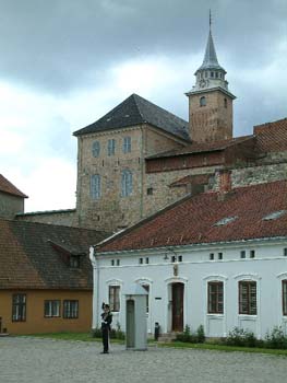
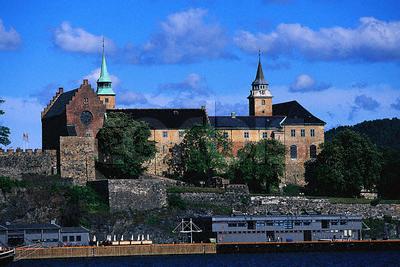
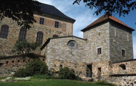
| Description | : | The royal mausoleum is a royal burial chapel at Akershus Castle in Oslo. The crypt is the long basement under Akershus Slottskapell; it acts as a front room for the mausoleum. It is built as a protrusion from the crypt into the walled patio garden (murinngjerdede terrassehagen) called Jomfruhagen between the castle and Jomfrutårnet on the right. The drawings for the chapel's design and location are dated April 1939. Work began in the winter of 1939/40 but stopped due to World War II. The royal mausoleum was consecrated on December 16, 1949, it... Read More |
frequently asked questions (FAQ):
-
Where is Det kongelige mausoleum i Akershus Slott?
Det kongelige mausoleum i Akershus Slott is located at Akershus Slott Oslo, Oslo kommune ,Oslo fylke , 0150Norway.
-
Det kongelige mausoleum i Akershus Slott cemetery's updated grave count on graveviews.com?
0 memorials
-
Where are the coordinates of the Det kongelige mausoleum i Akershus Slott?
Latitude: 59.9067600
Longitude: 10.7361560
Nearby Cemetories:
1. Krist kirkegård
Oslo, Oslo kommune, Norway
Coordinate: 59.9172300, 10.7467380
2. Mariekirkens ruin
Oslo, Oslo kommune, Norway
Coordinate: 59.9034515, 10.7621204
3. Vår Frelsers gravlund
Oslo, Oslo kommune, Norway
Coordinate: 59.9199500, 10.7435400
4. Hallvardskatedralens ruin
Oslo, Oslo kommune, Norway
Coordinate: 59.9058810, 10.7686740
5. Gamlebyen Gravlund
Oslo, Oslo kommune, Norway
Coordinate: 59.9046240, 10.7709790
6. Gamle Aker kirkegård
Oslo, Oslo kommune, Norway
Coordinate: 59.9237680, 10.7469560
7. Sofienberg jødiske gravlund
Oslo, Oslo kommune, Norway
Coordinate: 59.9229390, 10.7668660
8. Vestre Gravlund
Oslo, Oslo kommune, Norway
Coordinate: 59.9306100, 10.6998500
9. Vestre Aker kirkegård
Oslo, Oslo kommune, Norway
Coordinate: 59.9369400, 10.7291200
10. Nordre gravlund
Oslo, Oslo kommune, Norway
Coordinate: 59.9371400, 10.7483990
11. Bekkelaget urnelund
Oslo, Oslo kommune, Norway
Coordinate: 59.8849135, 10.7881908
12. Østre Gravlund
Oslo, Oslo kommune, Norway
Coordinate: 59.9130300, 10.8088490
13. Helsfyr gravlund
Oslo, Oslo kommune, Norway
Coordinate: 59.9132810, 10.8124210
14. Østre Aker kirkegård
Okern, Oslo kommune, Norway
Coordinate: 59.9217730, 10.8197180
15. Ris urnelund
Oslo, Oslo kommune, Norway
Coordinate: 59.9478110, 10.7012330
16. Ullern kirkegård
Oslo, Oslo kommune, Norway
Coordinate: 59.9252790, 10.6542960
17. Polhøgda Cemetery
Lysaker, Bærum kommune, Norway
Coordinate: 59.9052560, 10.6348830
18. Grefsen kirkegård
Oslo, Oslo kommune, Norway
Coordinate: 59.9553656, 10.7710968
19. Nordstrand kirkegård
Oslo, Oslo kommune, Norway
Coordinate: 59.8591400, 10.8031780
20. Alfaset – tysk krigskirkegård
Oslo, Oslo kommune, Norway
Coordinate: 59.9314700, 10.8559100
21. Voksen Cemetery
Oslo, Oslo kommune, Norway
Coordinate: 59.9566690, 10.6503380
22. Alfaset gravlund
Oslo, Oslo kommune, Norway
Coordinate: 59.9337100, 10.8583210
23. Haslum Cemetery
Haslum, Bærum kommune, Norway
Coordinate: 59.9247660, 10.5671860
24. Grorud kirkegård
Oslo, Oslo kommune, Norway
Coordinate: 59.9573990, 10.8841250