
| Memorials | : | 1 |
| Location | : | Oslo, Oslo kommune, Norway |
| Coordinate | : | 59.9034515, 10.7621204 |
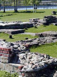
| Description | : | The St. Mary's Church (Mariakirken) was probably first built as a small wooden church around 1050. When Håkon V Magnusson became the country's king in 1299, he expanded the church (its 3rd conversion) into the third largest church building in the country at that time. It was only surpassed by the Nidaros Cathedral in Trondheim and St. Hallvard Cathedral (Hallvardskatedralen) 600 meters further up in Oslo. Both King Håkon V Magnusson (1319) and his queen, Eufemia (1312), were both buried in St. Mary's Church. After their remains (skulls) were found in the late... Read More |
frequently asked questions (FAQ):
-
Where is Mariekirkens ruin?
Mariekirkens ruin is located at Middelalderparken Oslo, Oslo kommune ,Oslo fylke , 0150Norway.
-
Mariekirkens ruin cemetery's updated grave count on graveviews.com?
1 memorials
-
Where are the coordinates of the Mariekirkens ruin?
Latitude: 59.9034515
Longitude: 10.7621204
Nearby Cemetories:
1. Hallvardskatedralens ruin
Oslo, Oslo kommune, Norway
Coordinate: 59.9058810, 10.7686740
2. Gamlebyen Gravlund
Oslo, Oslo kommune, Norway
Coordinate: 59.9046240, 10.7709790
3. Det kongelige mausoleum i Akershus Slott
Oslo, Oslo kommune, Norway
Coordinate: 59.9067600, 10.7361560
4. Krist kirkegård
Oslo, Oslo kommune, Norway
Coordinate: 59.9172300, 10.7467380
5. Vår Frelsers gravlund
Oslo, Oslo kommune, Norway
Coordinate: 59.9199500, 10.7435400
6. Sofienberg jødiske gravlund
Oslo, Oslo kommune, Norway
Coordinate: 59.9229390, 10.7668660
7. Gamle Aker kirkegård
Oslo, Oslo kommune, Norway
Coordinate: 59.9237680, 10.7469560
8. Bekkelaget urnelund
Oslo, Oslo kommune, Norway
Coordinate: 59.8849135, 10.7881908
9. Østre Gravlund
Oslo, Oslo kommune, Norway
Coordinate: 59.9130300, 10.8088490
10. Helsfyr gravlund
Oslo, Oslo kommune, Norway
Coordinate: 59.9132810, 10.8124210
11. Østre Aker kirkegård
Okern, Oslo kommune, Norway
Coordinate: 59.9217730, 10.8197180
12. Nordre gravlund
Oslo, Oslo kommune, Norway
Coordinate: 59.9371400, 10.7483990
13. Vestre Aker kirkegård
Oslo, Oslo kommune, Norway
Coordinate: 59.9369400, 10.7291200
14. Vestre Gravlund
Oslo, Oslo kommune, Norway
Coordinate: 59.9306100, 10.6998500
15. Nordstrand kirkegård
Oslo, Oslo kommune, Norway
Coordinate: 59.8591400, 10.8031780
16. Grefsen kirkegård
Oslo, Oslo kommune, Norway
Coordinate: 59.9553656, 10.7710968
17. Ris urnelund
Oslo, Oslo kommune, Norway
Coordinate: 59.9478110, 10.7012330
18. Alfaset – tysk krigskirkegård
Oslo, Oslo kommune, Norway
Coordinate: 59.9314700, 10.8559100
19. Alfaset gravlund
Oslo, Oslo kommune, Norway
Coordinate: 59.9337100, 10.8583210
20. Ullern kirkegård
Oslo, Oslo kommune, Norway
Coordinate: 59.9252790, 10.6542960
21. Polhøgda Cemetery
Lysaker, Bærum kommune, Norway
Coordinate: 59.9052560, 10.6348830
22. Voksen Cemetery
Oslo, Oslo kommune, Norway
Coordinate: 59.9566690, 10.6503380
23. Grorud kirkegård
Oslo, Oslo kommune, Norway
Coordinate: 59.9573990, 10.8841250
24. Klemetsrud kirkegård
Oslo, Oslo kommune, Norway
Coordinate: 59.8319960, 10.8513850