
| Memorials | : | 3 |
| Location | : | Eaton Center, Carroll County, USA |
| Coordinate | : | 43.9038890, -71.0572220 |
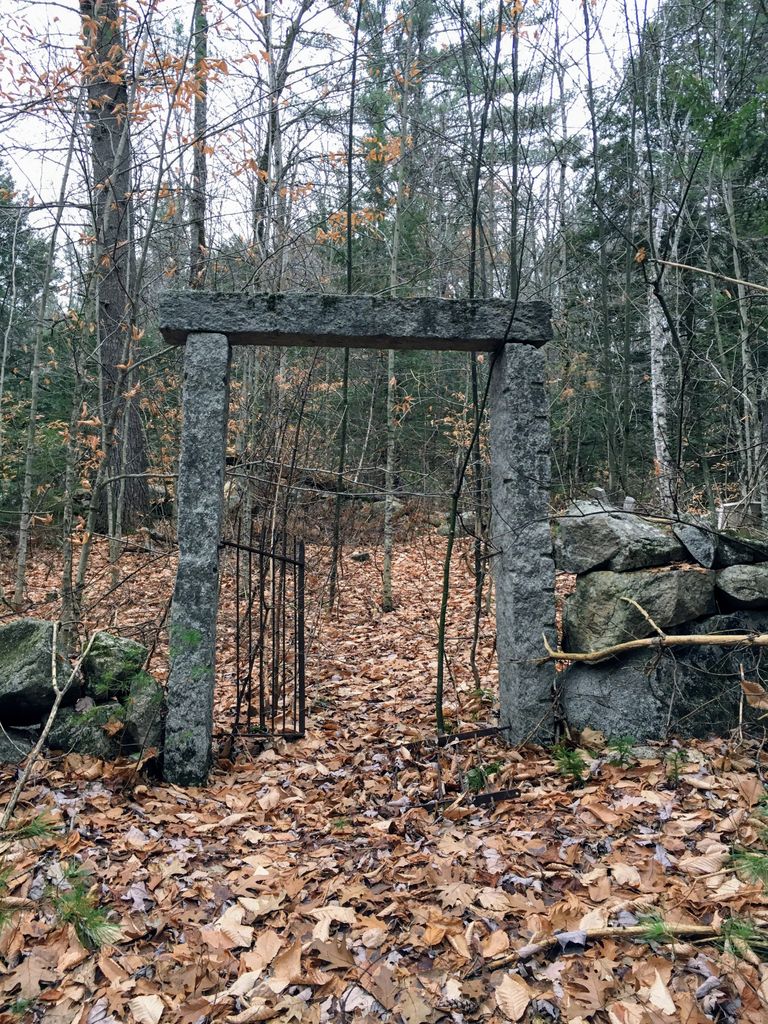
| Description | : | From its intersection with Brownfield Road, drive south on Stewart Road 0.5 miles to a house on the right west) side of the road. Park and follow a stone-wall lined path west from the house. Take a left at the fork in the wall and walk uphill to the south. The cemetery is surrounded by a stone wall and has a split granite post and lintel entrance. It is grown up with trees and most of the stones are broken and on the ground. |
frequently asked questions (FAQ):
-
Where is Drew-Kenneson Cemetery?
Drew-Kenneson Cemetery is located at Stewart Road Eaton Center, Carroll County ,New Hampshire ,USA.
-
Drew-Kenneson Cemetery cemetery's updated grave count on graveviews.com?
3 memorials
-
Where are the coordinates of the Drew-Kenneson Cemetery?
Latitude: 43.9038890
Longitude: -71.0572220

Nearby Cemetories:
1. Snowville Cemetery
Eaton Center, Carroll County, USA
Coordinate: 43.9109250, -71.0617630
2. Sawyer-Drew Cemetery
Eaton Center, Carroll County, USA
Coordinate: 43.9022200, -71.0453300
3. Bachelder Cemetery
Eaton, Carroll County, USA
Coordinate: 43.9140200, -71.0643600
4. Ward-Stuart Cemetery
Eaton, Carroll County, USA
Coordinate: 43.8995300, -71.0391100
5. Eaton Center Cemetery
Eaton Center, Carroll County, USA
Coordinate: 43.9087000, -71.0801000
6. Palmer Cemetery
Eaton, Carroll County, USA
Coordinate: 43.8973200, -71.0803000
7. Flood Cemetery
Eaton Center, Carroll County, USA
Coordinate: 43.8988890, -71.0333330
8. Garland Cemetery
Eaton, Carroll County, USA
Coordinate: 43.9111500, -71.0320300
9. Brooks Cemetery
Eaton, Carroll County, USA
Coordinate: 43.8860600, -71.0409300
10. Littlefield-Bean Cemetery
Eaton Center, Carroll County, USA
Coordinate: 43.9205560, -71.0372220
11. Elwell Cemetery
Eaton, Carroll County, USA
Coordinate: 43.8905200, -71.0819300
12. Jenness-Leavitt Cemetery
Eaton, Carroll County, USA
Coordinate: 43.8804900, -71.0565000
13. Glines Hill Cemetery
Eaton, Carroll County, USA
Coordinate: 43.9105500, -71.0889300
14. Jones Cemetery
Eaton, Carroll County, USA
Coordinate: 43.9310600, -71.0595400
15. Thompson-Stuart Cemetery
Eaton, Carroll County, USA
Coordinate: 43.9221000, -71.0274000
16. Perkins Cemetery
Eaton, Carroll County, USA
Coordinate: 43.9115300, -71.0160000
17. Hatch Perkins Cemetery
Eaton Center, Carroll County, USA
Coordinate: 43.9181000, -71.0170000
18. Allen Cemetery
Eaton, Carroll County, USA
Coordinate: 43.8698200, -71.0591800
19. Currier-Wilkinson Cemetery
Eaton, Carroll County, USA
Coordinate: 43.8708500, -71.0433400
20. Thurston Cemetery
Eaton Center, Carroll County, USA
Coordinate: 43.8690000, -71.0658000
21. Fernald Cemetery
Eaton, Carroll County, USA
Coordinate: 43.8825600, -71.0159200
22. Durgin Cemetery
Eaton Center, Carroll County, USA
Coordinate: 43.8700000, -71.0816670
23. Thurston-Meserve Cemetery
Eaton, Carroll County, USA
Coordinate: 43.9105100, -71.0027800
24. Frank Hart Cemetery
Eaton Center, Carroll County, USA
Coordinate: 43.9145100, -71.0039600