
| Memorials | : | 0 |
| Location | : | McCrea Furnace, Armstrong County, USA |
| Coordinate | : | 40.9242060, -79.2952070 |
| Description | : | From the intersection of Pennsylvania Route 28/66 and Pennsylvania Route 85, in Kittanning, PA, drive north, on 28/66, for a total of 6.90 miles to the village of Slabtown, at the intersection of SR 1018, often called Dayton Road. At this intersection, bear right onto SR 1018 and drive a total of 5.57 miles from this intersection to the intersection at Township 747. (T 747) On the way, you will pass the Concord Presbyterian Church Cemetery, on your left and from this cemetery the T 747 intersection is 1.62 miles. At this intersection, turn left onto T 747 and drive... Read More |
frequently asked questions (FAQ):
-
Where is McCreas Furnace Cemetery?
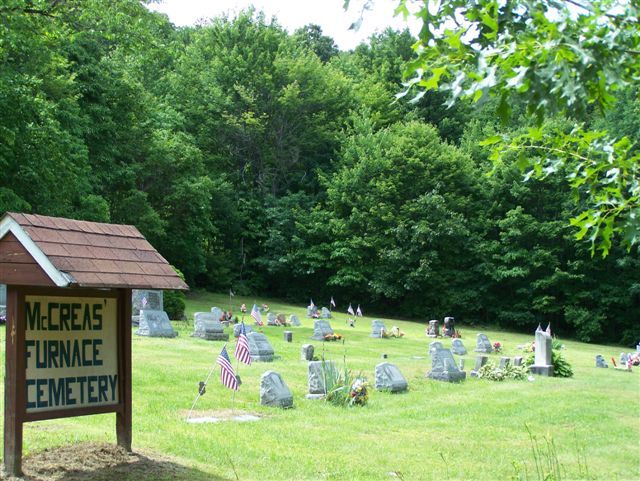
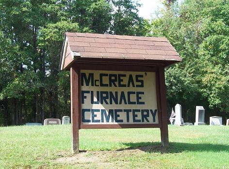
McCreas Furnace Cemetery is located at Curley's Road McCrea Furnace, Armstrong County ,Pennsylvania , 16222USA.
-
McCreas Furnace Cemetery cemetery's updated grave count on graveviews.com?
0 memorials
-
Where are the coordinates of the McCreas Furnace Cemetery?
Latitude: 40.9242060
Longitude: -79.2952070
Nearby Cemetories:
1. Milliron Family Cemetery
Putneyville, Armstrong County, USA
Coordinate: 40.9268490, -79.2997460
2. Saint Mark's Lutheran Church Cemetery
Eddyville, Armstrong County, USA
Coordinate: 40.9414139, -79.2808609
3. Putneyville Cemetery
Putneyville, Armstrong County, USA
Coordinate: 40.9426370, -79.3132420
4. Belknap Cemetery
Dayton, Armstrong County, USA
Coordinate: 40.8926000, -79.2957000
5. Concord Presbyterian Church Cemetery
Wayne Township, Armstrong County, USA
Coordinate: 40.8910599, -79.3240356
6. Jerusalem Lutheran Cemetery
Wayne Township, Armstrong County, USA
Coordinate: 40.9197006, -79.3566971
7. Smullin Cemetery
Distant, Armstrong County, USA
Coordinate: 40.9626000, -79.3346000
8. Colwell Cemetery
Armstrong County, USA
Coordinate: 40.9394520, -79.3633680
9. Emory Chapel Memorial Park
Dayton, Armstrong County, USA
Coordinate: 40.8882930, -79.2371320
10. Mudlic Cemetery
Charlestown, Armstrong County, USA
Coordinate: 40.9798490, -79.2758420
11. Copenhaver Crossroads Cemetery
Mc Gregor, Armstrong County, USA
Coordinate: 40.9379463, -79.2207184
12. Oakland Cemetery
Distant, Armstrong County, USA
Coordinate: 40.9712296, -79.3455124
13. Milton Cemetery
Milton, Armstrong County, USA
Coordinate: 40.9086720, -79.2170050
14. Rehobeth Reformed Presbyterian Church Cemetery
Kittanning, Armstrong County, USA
Coordinate: 40.8922670, -79.3695690
15. Dayton Glade Run Cemetery
Dayton, Armstrong County, USA
Coordinate: 40.8710136, -79.2356262
16. Saint Michael's Episcopal Cemetery
Rural Valley, Armstrong County, USA
Coordinate: 40.8542328, -79.3036499
17. Mount Zion Cemetery
Oak Ridge, Armstrong County, USA
Coordinate: 40.9951553, -79.3060226
18. Echo Methodist Episcopal Church Cemetery
Armstrong County, USA
Coordinate: 40.8570420, -79.3275330
19. New Salem Cemetery
Armstrong County, USA
Coordinate: 40.9887733, -79.2424927
20. United Presbyterian Cemetery
Dayton, Armstrong County, USA
Coordinate: 40.8652000, -79.2297000
21. Deanville Cemetery
Deanville, Armstrong County, USA
Coordinate: 40.9517700, -79.3919170
22. Timblin United Methodist Cemetery
Timblin, Jefferson County, USA
Coordinate: 40.9665620, -79.2057910
23. Fairview Cemetery
Porter, Jefferson County, USA
Coordinate: 40.9260941, -79.1888504
24. Narrows Cemetery
Mahoning, Armstrong County, USA
Coordinate: 40.9699000, -79.3839000