
| Memorials | : | 0 |
| Location | : | Rural Valley, Armstrong County, USA |
| Coordinate | : | 40.8542328, -79.3036499 |
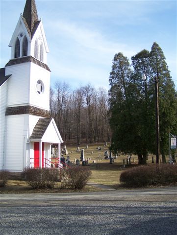
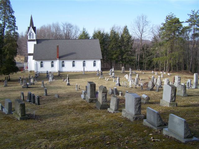
| Description | : | St. Michael's Episcopal Church was organized January 7, 1836, at the home of William McElhainey by the Rev. Byron Bernard Killikelly. Prior to that, services were conducted in private homes. In 1837, St. Michael's Congregation erected its first church. Driving directions: This Church and Cemetery is located on Lumstead Road (often Called St. Michael's Road or Township Route 760.) in Wayne Township, Armstrong County, PA. It is equal distance from Dayton, PA and Rural Valley, PA, but it is located in the Dayton Zip Code of 16222. From Eastbound, on Pennsylvania Route 85, as you enter Yatesboro/Rural Valley, PA, turn left,... Read More |
frequently asked questions (FAQ):
-
Where is Saint Michael's Episcopal Cemetery?
Saint Michael's Episcopal Cemetery is located at Rural Valley, Armstrong County ,Pennsylvania ,USA.
-
Saint Michael's Episcopal Cemetery cemetery's updated grave count on graveviews.com?
0 memorials
-
Where are the coordinates of the Saint Michael's Episcopal Cemetery?
Latitude: 40.8542328
Longitude: -79.3036499
Nearby Cemetories:
1. Echo Methodist Episcopal Church Cemetery
Armstrong County, USA
Coordinate: 40.8570420, -79.3275330
2. Schrecengost Farm Cemetery
Armstrong County, USA
Coordinate: 40.8288070, -79.3177450
3. Pleasant Union Cemetery
Cowanshannock Township, Armstrong County, USA
Coordinate: 40.8314018, -79.3350449
4. Belknap Cemetery
Dayton, Armstrong County, USA
Coordinate: 40.8926000, -79.2957000
5. Concord Presbyterian Church Cemetery
Wayne Township, Armstrong County, USA
Coordinate: 40.8910599, -79.3240356
6. Salem United Church of Christ Cemetery
Kittanning, Armstrong County, USA
Coordinate: 40.8244130, -79.3559970
7. Rural Valley Cemetery
Rural Valley, Armstrong County, USA
Coordinate: 40.8019714, -79.3118515
8. Dayton Glade Run Cemetery
Dayton, Armstrong County, USA
Coordinate: 40.8710136, -79.2356262
9. United Presbyterian Cemetery
Dayton, Armstrong County, USA
Coordinate: 40.8652000, -79.2297000
10. Emory Chapel Memorial Park
Dayton, Armstrong County, USA
Coordinate: 40.8882930, -79.2371320
11. Calhoun Cemetery
Armstrong County, USA
Coordinate: 40.8502426, -79.3848648
12. Rehobeth Reformed Presbyterian Church Cemetery
Kittanning, Armstrong County, USA
Coordinate: 40.8922670, -79.3695690
13. Bohan Family Farm Burial
Dayton, Armstrong County, USA
Coordinate: 40.7970470, -79.2572490
14. Elgin-Old Presbyterian Cemetery
Rural Valley, Armstrong County, USA
Coordinate: 40.8046646, -79.3662949
15. McCreas Furnace Cemetery
McCrea Furnace, Armstrong County, USA
Coordinate: 40.9242060, -79.2952070
16. Scott Fox Memorial Site
Kittanning, Armstrong County, USA
Coordinate: 40.8457580, -79.3972170
17. Milliron Family Cemetery
Putneyville, Armstrong County, USA
Coordinate: 40.9268490, -79.2997460
18. Jerusalem Lutheran Cemetery
Wayne Township, Armstrong County, USA
Coordinate: 40.9197006, -79.3566971
19. Harkleroad Cemetery
Rural Valley, Armstrong County, USA
Coordinate: 40.7718964, -79.3289719
20. Milton Cemetery
Milton, Armstrong County, USA
Coordinate: 40.9086720, -79.2170050
21. Slate Hill Cemetery
Dayton, Armstrong County, USA
Coordinate: 40.7946430, -79.2228310
22. Old Mahoning Baptist Cemetery
South Mahoning Township, Indiana County, USA
Coordinate: 40.8262620, -79.1944240
23. Mount Zion Presbyterian Cemetery
Boggs Township, Armstrong County, USA
Coordinate: 40.8717100, -79.4171980
24. Mateer Cemetery
Armstrong County, USA
Coordinate: 40.8721000, -79.4175000