
| Memorials | : | 6 |
| Location | : | Elderton, Armstrong County, USA |
| Coordinate | : | 40.6876678, -79.3781967 |
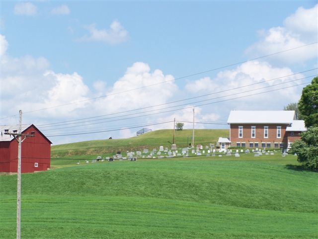
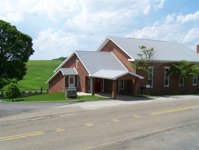
| Description | : | This cemetery is located 2.14 miles from the intersection, of Saltwork Street and U.S. Route 422, in Elderton, Pa. and it is at the intersecton of Cherry Run Road (AKA SR 2024) and Girty Road. (Saltwork Street is also known as Girty Road.) |
frequently asked questions (FAQ):
-
Where is Mount Union Lutheran Church Cemetery?
Mount Union Lutheran Church Cemetery is located at Elderton, Armstrong County ,Pennsylvania ,USA.
-
Mount Union Lutheran Church Cemetery cemetery's updated grave count on graveviews.com?
0 memorials
-
Where are the coordinates of the Mount Union Lutheran Church Cemetery?
Latitude: 40.6876678
Longitude: -79.3781967

Nearby Cemetories:
1. Rowley Cemetery
Elderton, Armstrong County, USA
Coordinate: 40.6889750, -79.4027500
2. Elderton United Methodist Church Cemetery
Elderton, Armstrong County, USA
Coordinate: 40.6941681, -79.3455887
3. Elderton Cemetery
Elderton, Armstrong County, USA
Coordinate: 40.6918000, -79.3436000
4. Elderton Presbyterian Church Cemetery
Elderton, Armstrong County, USA
Coordinate: 40.6972520, -79.3432240
5. Montgomery Family Cemetery
South Bend, Armstrong County, USA
Coordinate: 40.6597000, -79.3714000
6. Kimmel Cemetery
Elderton, Armstrong County, USA
Coordinate: 40.6910190, -79.3346140
7. Rupert Cemetery
Girty, Armstrong County, USA
Coordinate: 40.6596550, -79.4020500
8. Mount Zion United Methodist Church Cemetery
Girty, Armstrong County, USA
Coordinate: 40.6555710, -79.4134674
9. Pettigrew Cemetery
Elderton, Armstrong County, USA
Coordinate: 40.7330560, -79.3991670
10. Gastown Cemetery
Gastown, Armstrong County, USA
Coordinate: 40.7081000, -79.3180000
11. Shaeffer Cemetery
Brick Church, Armstrong County, USA
Coordinate: 40.6927986, -79.4441986
12. South Bend Cemetery
Elderton, Armstrong County, USA
Coordinate: 40.6370087, -79.3699417
13. Whitesburg Presbyterian Cemetery
Armstrong County, USA
Coordinate: 40.7371000, -79.3959000
14. Whitesburg United Methodist Church Cemetery
Whitesburg, Armstrong County, USA
Coordinate: 40.7384000, -79.3964000
15. McDonald Cemetery
Burrell Township, Armstrong County, USA
Coordinate: 40.6603012, -79.4464035
16. Saint Michael's Lutheran Church Cemetery
Brick Church, Armstrong County, USA
Coordinate: 40.6831360, -79.4557114
17. United Rockville Lutheran Cemetery
Ford City, Armstrong County, USA
Coordinate: 40.7305260, -79.4382095
18. Ramaley Family Cemetery
Cochrans Mills, Armstrong County, USA
Coordinate: 40.6574780, -79.4585220
19. Saint John's Lutheran Church Cemetery
Ford City, Armstrong County, USA
Coordinate: 40.7197037, -79.4614410
20. Shoemaker Family Cemetery
Cochrans Mills, Armstrong County, USA
Coordinate: 40.6639400, -79.4665790
21. Cochrans Mill United Methodist Church Cemetery
Cochrans Mills, Armstrong County, USA
Coordinate: 40.6706000, -79.4700000
22. Shelocta Presbyterian Cemetery
Indiana County, USA
Coordinate: 40.6527820, -79.2930830
23. Dunkard Baptist Christian Bretheren Cemetery
Cochrans Mills, Armstrong County, USA
Coordinate: 40.6697655, -79.4726105
24. Saint Paul's Cemetery
Rural Valley, Armstrong County, USA
Coordinate: 40.7620583, -79.3640823