
| Memorials | : | 1 |
| Location | : | Ockley, Mole Valley District, England |
| Coordinate | : | 51.1473610, -0.3654400 |
frequently asked questions (FAQ):
-
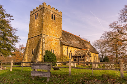
Where is Ockley Cemetery?
Ockley Cemetery is located at School Lane Ockley, Mole Valley District ,Surrey , RH5 5TREngland.
-
Ockley Cemetery cemetery's updated grave count on graveviews.com?
1 memorials
-
Where are the coordinates of the Ockley Cemetery?
Latitude: 51.1473610
Longitude: -0.3654400
Nearby Cemetories:
1. St Margaret Churchyard
Ockley, Mole Valley District, England
Coordinate: 51.1534880, -0.3473790
2. St John the Baptist Churchyard
Oakwoodhill, Mole Valley District, England
Coordinate: 51.1304600, -0.3895700
3. Okewood St John the Baptist Churchyard
Ewhurst, Waverley Borough, England
Coordinate: 51.1303800, -0.3895000
4. Capel Friends Burial Ground #2
Capel, Mole Valley District, England
Coordinate: 51.1513970, -0.3219210
5. St. John the Baptist Churchyard
Capel, Mole Valley District, England
Coordinate: 51.1539730, -0.3201980
6. Pleystowe in Capel Friends Grounds
Capel, Mole Valley District, England
Coordinate: 51.1411900, -0.3161300
7. Christ Church Churchyard
Coldharbour, Mole Valley District, England
Coordinate: 51.1807050, -0.3576190
8. St Peter & St Paul Churchyard
Ewhurst, Waverley Borough, England
Coordinate: 51.1530910, -0.4409600
9. St Mary Magdalene Churchyard
South Holmwood, Mole Valley District, England
Coordinate: 51.1904660, -0.3243540
10. St Mary the Virgin Churchyard
Holmbury St Mary, Mole Valley District, England
Coordinate: 51.1882600, -0.4130600
11. St Peter Churchyard
Newdigate, Mole Valley District, England
Coordinate: 51.1652200, -0.2884860
12. Felday Chapel
Holmbury St Mary, Mole Valley District, England
Coordinate: 51.1900360, -0.4129370
13. St. Margaret Churchyard
Warnham, Horsham District, England
Coordinate: 51.0903160, -0.3462410
14. Saint Mary Magdalene Churchyard
Rusper, Horsham District, England
Coordinate: 51.1227750, -0.2789080
15. St James Churchyard
Abinger, Mole Valley District, England
Coordinate: 51.2017820, -0.4056060
16. Holy Trinity Churchyard
Rudgwick, Horsham District, England
Coordinate: 51.0973900, -0.4442800
17. St John the Evangelist Churchyard
Wotton, Mole Valley District, England
Coordinate: 51.2198770, -0.3895890
18. Cranleigh Cemetery
Cranleigh, Waverley Borough, England
Coordinate: 51.1432100, -0.4845330
19. St Nicolas Churchyard
Cranleigh, Waverley Borough, England
Coordinate: 51.1408830, -0.4860670
20. Holy Trinity Churchyard, Westcott
Dorking, Mole Valley District, England
Coordinate: 51.2236075, -0.3694870
21. St Peter Churchyard
Slinfold, Horsham District, England
Coordinate: 51.0725490, -0.4057220
22. Hills Cemetery
Horsham, Horsham District, England
Coordinate: 51.0645800, -0.3463350
23. Roffey Cemetery
Horsham, Horsham District, England
Coordinate: 51.0769320, -0.2930890
24. Charlwood Friends Burial Ground
Charlwood, Mole Valley District, England
Coordinate: 51.1553700, -0.2305800