
| Memorials | : | 0 |
| Location | : | Potton, Central Bedfordshire Unitary Authority, England |
| Coordinate | : | 52.1242617, -0.2096524 |
frequently asked questions (FAQ):
-
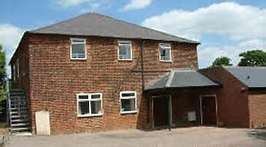
Where is Potton Baptist Church (Defunct)?
Potton Baptist Church (Defunct) is located at Horslow Street Potton, Central Bedfordshire Unitary Authority ,Bedfordshire ,England.
-
Potton Baptist Church (Defunct) cemetery's updated grave count on graveviews.com?
0 memorials
-
Where are the coordinates of the Potton Baptist Church (Defunct)?
Latitude: 52.1242617
Longitude: -0.2096524
Nearby Cemetories:
1. St Mary the Virgin Churchyard
Potton, Central Bedfordshire Unitary Authority, England
Coordinate: 52.1295800, -0.2066700
2. All Saints Churchyard
Sutton, Central Bedfordshire Unitary Authority, England
Coordinate: 52.1126500, -0.2212200
3. St John the Baptist Churchyard
Cockayne Hatley, Central Bedfordshire Unitary Authority, England
Coordinate: 52.1308660, -0.1663740
4. St Mary the Virgin Churchyard
Gamlingay, South Cambridgeshire District, England
Coordinate: 52.1549840, -0.1872690
5. All Saints Churchyard
Eyeworth, Central Bedfordshire Unitary Authority, England
Coordinate: 52.0945940, -0.1770800
6. Stratton Way Cemetery
Biggleswade, Central Bedfordshire Unitary Authority, England
Coordinate: 52.0919432, -0.2474864
7. Sandy Cemetery
Sandy, Central Bedfordshire Unitary Authority, England
Coordinate: 52.1245500, -0.2783300
8. St Mary Magdalene Churchyard
Dunton, Central Bedfordshire Unitary Authority, England
Coordinate: 52.0825200, -0.1955600
9. Dunton Cemetery
Dunton, Central Bedfordshire Unitary Authority, England
Coordinate: 52.0820490, -0.1982770
10. Drove Road Cemetery
Biggleswade, Central Bedfordshire Unitary Authority, England
Coordinate: 52.0895000, -0.2527300
11. St Swithun Churchyard
Sandy, Central Bedfordshire Unitary Authority, England
Coordinate: 52.1273583, -0.2862773
12. Old Baptist Burial Ground
Sandy, Central Bedfordshire Unitary Authority, England
Coordinate: 52.1299590, -0.2884590
13. St George Church
Hatley St George, South Cambridgeshire District, England
Coordinate: 52.1437000, -0.1348000
14. St Andrew Churchyard
Biggleswade, Central Bedfordshire Unitary Authority, England
Coordinate: 52.0875360, -0.2666970
15. St. Denis Churchyard
East Hatley, South Cambridgeshire District, England
Coordinate: 52.1379956, -0.1233863
16. St. James the Great New Churchyard
Waresley, Huntingdonshire District, England
Coordinate: 52.1747700, -0.1740900
17. St James the Great Old Churchyard
Waresley, Huntingdonshire District, England
Coordinate: 52.1740400, -0.1710700
18. Guilden Morden Burial Ground
Guilden Morden, South Cambridgeshire District, England
Coordinate: 52.0832700, -0.1311000
19. St. Mary's Churchyard
Guilden Morden, South Cambridgeshire District, England
Coordinate: 52.0806930, -0.1336810
20. St Peter & St Paul Churchyard
Little Gransden, South Cambridgeshire District, England
Coordinate: 52.1801800, -0.1427200
21. Tempsford Village Cemetery
Tempsford, Central Bedfordshire Unitary Authority, England
Coordinate: 52.1639000, -0.3024500
22. Langford Cemetery
Langford, Central Bedfordshire Unitary Authority, England
Coordinate: 52.0640000, -0.2710830
23. St Bartholomew Churchyard
Great Gransden, Huntingdonshire District, England
Coordinate: 52.1841660, -0.1425220
24. St Mary the Virgin Churchyard
Northill, Central Bedfordshire Unitary Authority, England
Coordinate: 52.1053300, -0.3239650