| Memorials | : | 0 |
| Location | : | Cockayne Hatley, Central Bedfordshire Unitary Authority, England |
| Coordinate | : | 52.1308660, -0.1663740 |
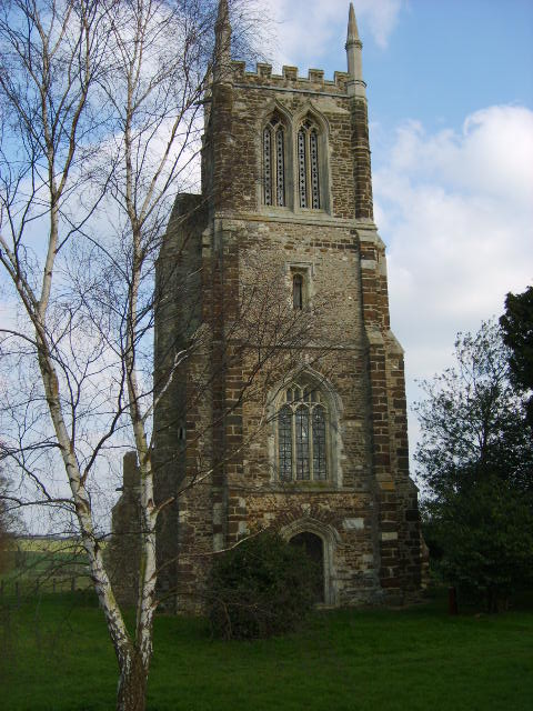
| Description | : | The church consists of a chancel 19 ft. 6 in. by 16 ft. 3 in., nave 36 ft. by 18 ft., with north aisle 5 ft. 9 in. wide and south aisle 6 ft. wide, and west tower 12 ft. 8 in. by 13 ft. 4 in., all internal measurements. The plan, owing to successive rebuildings and additions, is one of extreme irregularity, the chancel, nave, and tower being all set at different angles, and only the tower being rectangular on plan. The earliest part of the church now existing is the north arcade of the nave, belonging to the latter... Read More |
frequently asked questions (FAQ):
-
Where is St John the Baptist Churchyard?
St John the Baptist Churchyard is located at Cockayne Hatley, Central Bedfordshire Unitary Authority ,Bedfordshire ,England.
-
St John the Baptist Churchyard cemetery's updated grave count on graveviews.com?
0 memorials
-
Where are the coordinates of the St John the Baptist Churchyard?
Latitude: 52.1308660
Longitude: -0.1663740
Nearby Cemetories:
1. St George Church
Hatley St George, South Cambridgeshire District, England
Coordinate: 52.1437000, -0.1348000
2. St Mary the Virgin Churchyard
Potton, Central Bedfordshire Unitary Authority, England
Coordinate: 52.1295800, -0.2066700
3. St Mary the Virgin Churchyard
Gamlingay, South Cambridgeshire District, England
Coordinate: 52.1549840, -0.1872690
4. St. Denis Churchyard
East Hatley, South Cambridgeshire District, England
Coordinate: 52.1379956, -0.1233863
5. Potton Baptist Church (Defunct)
Potton, Central Bedfordshire Unitary Authority, England
Coordinate: 52.1242617, -0.2096524
6. All Saints Churchyard
Eyeworth, Central Bedfordshire Unitary Authority, England
Coordinate: 52.0945940, -0.1770800
7. All Saints Churchyard
Sutton, Central Bedfordshire Unitary Authority, England
Coordinate: 52.1126500, -0.2212200
8. St James the Great Old Churchyard
Waresley, Huntingdonshire District, England
Coordinate: 52.1740400, -0.1710700
9. St. James the Great New Churchyard
Waresley, Huntingdonshire District, England
Coordinate: 52.1747700, -0.1740900
10. St Peter & St Paul Churchyard
Little Gransden, South Cambridgeshire District, England
Coordinate: 52.1801800, -0.1427200
11. St Mary Magdalene Churchyard
Dunton, Central Bedfordshire Unitary Authority, England
Coordinate: 52.0825200, -0.1955600
12. Guilden Morden Burial Ground
Guilden Morden, South Cambridgeshire District, England
Coordinate: 52.0832700, -0.1311000
13. Dunton Cemetery
Dunton, Central Bedfordshire Unitary Authority, England
Coordinate: 52.0820490, -0.1982770
14. All Saints Churchyard
Croydon, South Cambridgeshire District, England
Coordinate: 52.1290100, -0.0796720
15. St. Mary's Churchyard
Guilden Morden, South Cambridgeshire District, England
Coordinate: 52.0806930, -0.1336810
16. St Bartholomew Churchyard
Great Gransden, Huntingdonshire District, England
Coordinate: 52.1841660, -0.1425220
17. All Saints Churchyard
Wendy, South Cambridgeshire District, England
Coordinate: 52.1110400, -0.0703100
18. St Nicholas Churchyard
Arrington, South Cambridgeshire District, England
Coordinate: 52.1352130, -0.0652100
19. St Michael and All Angels Churchyard
Abington Pigotts, South Cambridgeshire District, England
Coordinate: 52.0849450, -0.0976970
20. Stratton Way Cemetery
Biggleswade, Central Bedfordshire Unitary Authority, England
Coordinate: 52.0919432, -0.2474864
21. Drove Road Cemetery
Biggleswade, Central Bedfordshire Unitary Authority, England
Coordinate: 52.0895000, -0.2527300
22. Sandy Cemetery
Sandy, Central Bedfordshire Unitary Authority, England
Coordinate: 52.1245500, -0.2783300
23. St Peter and St Paul
Steeple Morden, South Cambridgeshire District, England
Coordinate: 52.0655979, -0.1257247
24. St Mary The Virgin
Longstowe, South Cambridgeshire District, England
Coordinate: 52.1815300, -0.0845300


