
| Memorials | : | 0 |
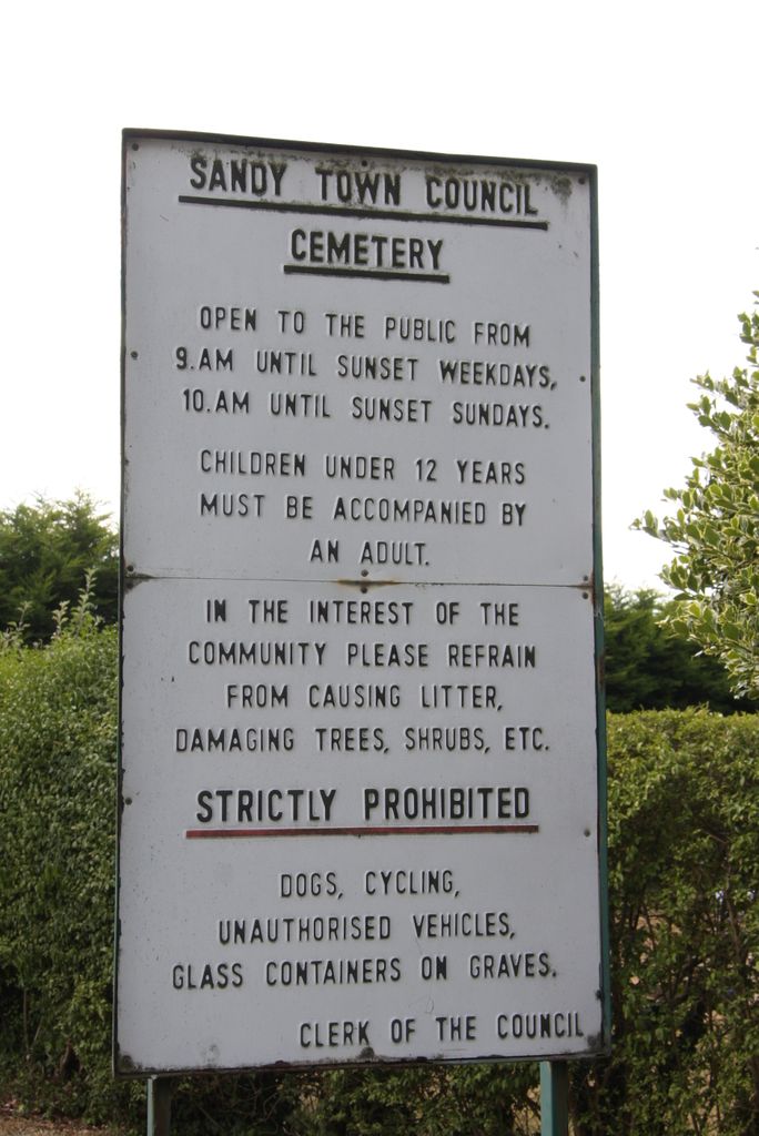
| Location | : | Sandy, Central Bedfordshire Unitary Authority, England |
| Coordinate | : | 52.1245500, -0.2783300 |
frequently asked questions (FAQ):
-
Where is Sandy Cemetery?
Sandy Cemetery is located at Potton Road Sandy, Central Bedfordshire Unitary Authority ,Bedfordshire ,England.
-
Sandy Cemetery cemetery's updated grave count on graveviews.com?
0 memorials
-
Where are the coordinates of the Sandy Cemetery?
Latitude: 52.1245500
Longitude: -0.2783300
Nearby Cemetories:
1. St Swithun Churchyard
Sandy, Central Bedfordshire Unitary Authority, England
Coordinate: 52.1273583, -0.2862773
2. Old Baptist Burial Ground
Sandy, Central Bedfordshire Unitary Authority, England
Coordinate: 52.1299590, -0.2884590
3. St. John the Evangelist Churchyard
Mogerhanger, Central Bedfordshire Unitary Authority, England
Coordinate: 52.1305000, -0.3325000
4. St Mary the Virgin Churchyard
Northill, Central Bedfordshire Unitary Authority, England
Coordinate: 52.1053300, -0.3239650
5. All Saints Churchyard
Sutton, Central Bedfordshire Unitary Authority, England
Coordinate: 52.1126500, -0.2212200
6. St Andrew Churchyard
Biggleswade, Central Bedfordshire Unitary Authority, England
Coordinate: 52.0875360, -0.2666970
7. Stratton Way Cemetery
Biggleswade, Central Bedfordshire Unitary Authority, England
Coordinate: 52.0919432, -0.2474864
8. Drove Road Cemetery
Biggleswade, Central Bedfordshire Unitary Authority, England
Coordinate: 52.0895000, -0.2527300
9. Tempsford Village Cemetery
Tempsford, Central Bedfordshire Unitary Authority, England
Coordinate: 52.1639000, -0.3024500
10. Potton Baptist Church (Defunct)
Potton, Central Bedfordshire Unitary Authority, England
Coordinate: 52.1242617, -0.2096524
11. St Mary the Virgin Churchyard
Potton, Central Bedfordshire Unitary Authority, England
Coordinate: 52.1295800, -0.2066700
12. All Saints Churchyard
Great Barford, Bedford Borough, England
Coordinate: 52.1520280, -0.3439850
13. St. Leonard's Churchyard
Old Warden, Central Bedfordshire Unitary Authority, England
Coordinate: 52.0855860, -0.3424550
14. St. Mary Magdalene Churchyard
Roxton, Bedford Borough, England
Coordinate: 52.1769310, -0.3146280
15. Langford Cemetery
Langford, Central Bedfordshire Unitary Authority, England
Coordinate: 52.0640000, -0.2710830
16. St Mary the Virgin Churchyard
Gamlingay, South Cambridgeshire District, England
Coordinate: 52.1549840, -0.1872690
17. Dunton Cemetery
Dunton, Central Bedfordshire Unitary Authority, England
Coordinate: 52.0820490, -0.1982770
18. St Mary Magdalene Churchyard
Dunton, Central Bedfordshire Unitary Authority, England
Coordinate: 52.0825200, -0.1955600
19. All Saints Churchyard
Southill, Central Bedfordshire Unitary Authority, England
Coordinate: 52.0666240, -0.3298690
20. St Andrew Churchyard
Langford, Central Bedfordshire Unitary Authority, England
Coordinate: 52.0583270, -0.2721350
21. St. Lawrence's Churchyard
Willington, Bedford Borough, England
Coordinate: 52.1362631, -0.3847213
22. All Saints Churchyard
Cople, Bedford Borough, England
Coordinate: 52.1235000, -0.3899000
23. St John the Baptist Churchyard
Cockayne Hatley, Central Bedfordshire Unitary Authority, England
Coordinate: 52.1308660, -0.1663740
24. All Saints Churchyard
Eyeworth, Central Bedfordshire Unitary Authority, England
Coordinate: 52.0945940, -0.1770800