
| Memorials | : | 0 |
| Location | : | Eden District, England |
| Coordinate | : | 54.5057950, -2.1486260 |
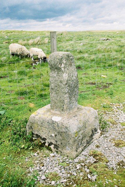
| Description | : | Rey Cross is believed to have been ten feet tall, a long-held local legend states it was the burial place of Eric Bloodaxe, Viking Ruler of Northumbria. |
frequently asked questions (FAQ):
-
Where is Rey Cross?
Rey Cross is located at Barnard Castle DL11 6ED, United Kingdom Eden District ,Cumbria ,England.
-
Rey Cross cemetery's updated grave count on graveviews.com?
0 memorials
-
Where are the coordinates of the Rey Cross?
Latitude: 54.5057950
Longitude: -2.1486260
Nearby Cemetories:
1. Bowes and Gilmonby Cemetery
Bowes, Durham Unitary Authority, England
Coordinate: 54.5164600, -2.0124100
2. St Giles Churchyard
Bowes, Durham Unitary Authority, England
Coordinate: 54.5169000, -2.0124000
3. Keld United Reform Chapelyard
Keld, Richmondshire District, England
Coordinate: 54.4055920, -2.1660210
4. St Michael Churchyard
Brough, Eden District, England
Coordinate: 54.5201950, -2.3210920
5. Lune Chapel Churchyard
Laithkirk, Durham Unitary Authority, England
Coordinate: 54.6115800, -2.0717400
6. Cotherstone Cemetery
Cotherstone, Durham Unitary Authority, England
Coordinate: 54.5680830, -1.9804850
7. Cotherstone Friends Burial Ground
Cotherstone, Durham Unitary Authority, England
Coordinate: 54.5722230, -1.9824740
8. Church of Saint Mary the Virgin Graveyard
Arkengarthdale, Richmondshire District, England
Coordinate: 54.4225063, -2.0013365
9. St. Romald Churchyard
Romaldkirk, Durham Unitary Authority, England
Coordinate: 54.5941550, -2.0089636
10. St Stephen Churchyard
Kirkby Stephen, Eden District, England
Coordinate: 54.4740890, -2.3485130
11. Kirkby Stephen Cemetery
Kirkby Stephen, Eden District, England
Coordinate: 54.4784680, -2.3507840
12. Romaldkirk Cemetery
Romaldkirk, Durham Unitary Authority, England
Coordinate: 54.5977800, -2.0083200
13. St Theobald Churchyard
Musgrave, Eden District, England
Coordinate: 54.5138380, -2.3605080
14. St Theobald's Church
Great Musgrave, Eden District, England
Coordinate: 54.5139410, -2.3605410
15. St. Mary the Virgin Churchyard
Langthwaite, Richmondshire District, England
Coordinate: 54.4195260, -1.9967580
16. Langthwaite Wesleyan Methodist Chapelyard
Langthwaite, Richmondshire District, England
Coordinate: 54.4181000, -1.9958500
17. Middleton On Teesdale Churchyard
Middleton-in-Teesdale, Durham Unitary Authority, England
Coordinate: 54.6257980, -2.0825420
18. St. Mary's Churchyard
Muker, Richmondshire District, England
Coordinate: 54.3763690, -2.1392860
19. Chapel of Ease
Eggleston, Durham Unitary Authority, England
Coordinate: 54.6058000, -2.0050000
20. Holy Trinity Churchyard
Eggleston, Durham Unitary Authority, England
Coordinate: 54.6082390, -2.0037610
21. Gunnerside Wesleyan Methodist Chapelyard
Gunnerside, Richmondshire District, England
Coordinate: 54.3783950, -2.0778320
22. St. Mary's Churchyard
Barnard Castle, Durham Unitary Authority, England
Coordinate: 54.5416950, -1.9230780
23. Soulby Cemetery
Soulby, Eden District, England
Coordinate: 54.4943900, -2.3834200
24. St Mary's Roman Catholic Church
Barnard Castle, Durham Unitary Authority, England
Coordinate: 54.5414010, -1.9183080