
| Memorials | : | 0 |
| Location | : | Dorton, Aylesbury Vale District, England |
| Phone | : | 44 1844 237441 |
| Website | : | www.bernwodebenefice.com/dorton |
| Coordinate | : | 51.8198434, -1.0162377 |
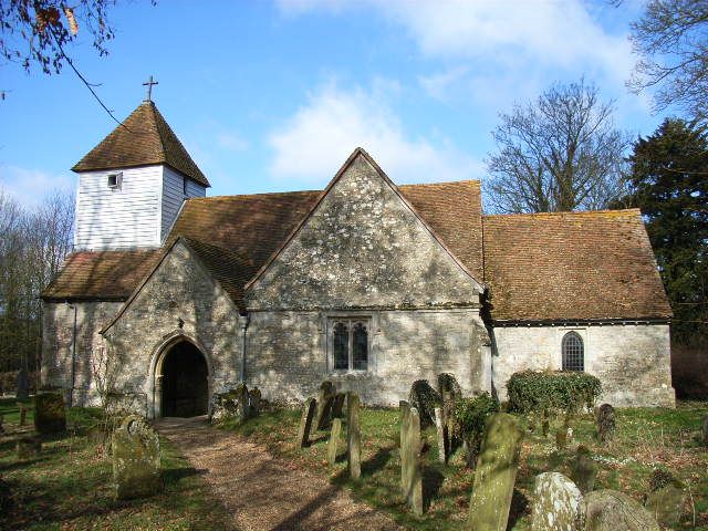
| Description | : | St John the Baptist's church in Dorton is a member of the Bernwode Benefice. The village of Dorton lies 5 miles north of Thame and has 59 houses and 166 inhabitants. Although there is no pub, shop or village hall for the villagers to gather in, there is a strong community spirit and everyone can be relied upon to support fund raising for the church or help neighbours in need. St John the Baptist church was built as a chapel of ease and is thought to date back to the 12th century with the font bowl surviving from this time. |
frequently asked questions (FAQ):
-
Where is St John the Baptist?
St John the Baptist is located at Dorton, Aylesbury Vale District, Buckinghamshire, England Dorton, Aylesbury Vale District ,Buckinghamshire , HP18 9NGEngland.
-
St John the Baptist cemetery's updated grave count on graveviews.com?
0 memorials
-
Where are the coordinates of the St John the Baptist?
Latitude: 51.8198434
Longitude: -1.0162377
Nearby Cemetories:
1. All Saints Churchyard
Brill, Aylesbury Vale District, England
Coordinate: 51.8196440, -1.0490570
2. St. Mary's Churchyard
Chilton, Aylesbury Vale District, England
Coordinate: 51.7988760, -1.0055490
3. St Marys Churchyard
Ashendon, Aylesbury Vale District, England
Coordinate: 51.8221320, -0.9784380
4. St. Mary the Virgin Churchyard
Ludgershall, Aylesbury Vale District, England
Coordinate: 51.8495250, -1.0434220
5. St Mary Churchyard
Oakley, Aylesbury Vale District, England
Coordinate: 51.8054770, -1.0704700
6. St Marys Churchyard
Westcott, Aylesbury Vale District, England
Coordinate: 51.8482790, -0.9609600
7. St John the Baptist Churchyard
Piddington, Cherwell District, England
Coordinate: 51.8477859, -1.0723360
8. St Nicholas Churchyard
Piddington, Cherwell District, England
Coordinate: 51.8477520, -1.0723950
9. St Mary the Virgin Churchyard
Long Crendon, Aylesbury Vale District, England
Coordinate: 51.7758380, -0.9890670
10. St. James' Churchyard
Boarstall, Aylesbury Vale District, England
Coordinate: 51.8218170, -1.0926460
11. Baptist Chapel Burial Ground
Long Crendon, Aylesbury Vale District, England
Coordinate: 51.7730713, -0.9929426
12. St Nicholas Churchyard
Chearsley, Aylesbury Vale District, England
Coordinate: 51.7868900, -0.9571600
13. St. Nicholas' Churchyard
Nether Winchendon, Aylesbury Vale District, England
Coordinate: 51.8041000, -0.9388000
14. St. Nicholas Churchyard
Cuddington, Aylesbury Vale District, England
Coordinate: 51.7944300, -0.9320400
15. St Mary Magdalene Churchyard
Upper Winchendon, Aylesbury Vale District, England
Coordinate: 51.8240620, -0.9192140
16. St. Michael and All Angels Churchyard
Waddesdon, Aylesbury Vale District, England
Coordinate: 51.8464760, -0.9269500
17. St Leonard Churchyard
Grendon Underwood, Aylesbury Vale District, England
Coordinate: 51.8832800, -1.0174800
18. St. Mary Magdalene Churchyard
Shabbington, Aylesbury Vale District, England
Coordinate: 51.7554420, -1.0357510
19. St. Nicholas' Churchyard
Ickford, Aylesbury Vale District, England
Coordinate: 51.7614648, -1.0656459
20. Waddesdon Hill Strict Baptist Chapel Chapelyard
Waddesdon, Aylesbury Vale District, England
Coordinate: 51.8289880, -0.9083030
21. Saint Mary The Virgin Churchyard
Thame, South Oxfordshire District, England
Coordinate: 51.7511750, -0.9819190
22. White Friar's Church
Oxford, City of Oxford, England
Coordinate: 51.7710000, -0.9288600
23. Haddenham Baptist Church Graveyard
Haddenham, Aylesbury Vale District, England
Coordinate: 51.7706830, -0.9274900
24. Studley Priory
Horton-cum-Studley, Cherwell District, England
Coordinate: 51.8054560, -1.1346920