
| Memorials | : | 0 |
| Location | : | Grendon Underwood, Aylesbury Vale District, England |
| Coordinate | : | 51.8832800, -1.0174800 |
| Description | : | Grendon Underwood is a village and civil parish in Aylesbury Vale district in Buckinghamshire, England. It is in the west of the county, close to the boundary with Oxfordshire and near the Roman road Akeman Street. The toponym is derived from the Old English for 'green hill near a wood', though the 'Underwood' part of the name was only added in the medieval period to differentiate the village from nearby Long Crendon and to signify the village's position near the Bernwood Forest. The Domesday Book of 1086 records the village as Grennedone. The manor of Grendon anciently belonged to the St Amand... Read More |
frequently asked questions (FAQ):
-
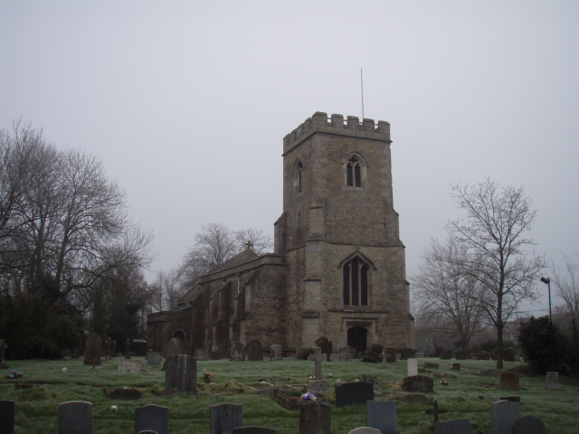
Where is St Leonard Churchyard?
St Leonard Churchyard is located at The Broadway Grendon Underwood, Aylesbury Vale District ,Buckinghamshire ,England.
-
St Leonard Churchyard cemetery's updated grave count on graveviews.com?
0 memorials
-
Where are the coordinates of the St Leonard Churchyard?
Latitude: 51.8832800
Longitude: -1.0174800
Nearby Cemetories:
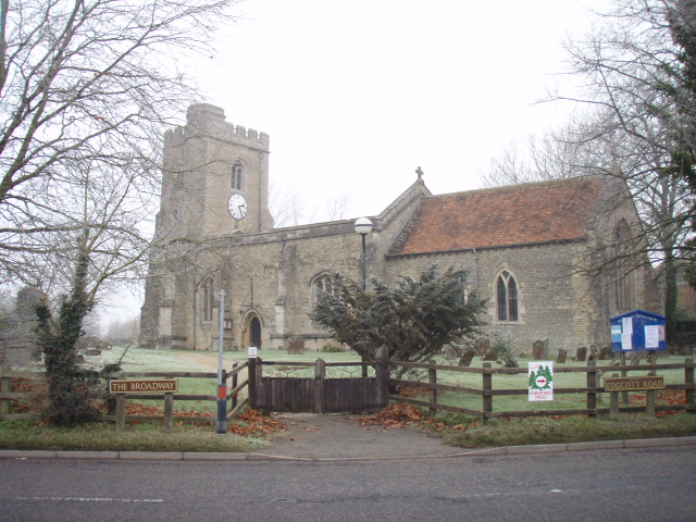
1. St Michael and All Angels Churchyard
Edgcott, Aylesbury Vale District, England
Coordinate: 51.8995450, -1.0132210
2. Marsh Gibbon Cemetery
Bicester, Cherwell District, England
Coordinate: 51.9000250, -1.0607810
3. St Mary the Virgin Churchyard
Marsh Gibbon, Aylesbury Vale District, England
Coordinate: 51.9038310, -1.0601060
4. St. Mary the Virgin Churchyard
Ludgershall, Aylesbury Vale District, England
Coordinate: 51.8495250, -1.0434220
5. St John the Baptist Churchyard
Piddington, Cherwell District, England
Coordinate: 51.8477859, -1.0723360
6. St Nicholas Churchyard
Piddington, Cherwell District, England
Coordinate: 51.8477520, -1.0723950
7. St Marys Churchyard
Westcott, Aylesbury Vale District, England
Coordinate: 51.8482790, -0.9609600
8. Assumption of BVM Churchyard
Twyford, Aylesbury Vale District, England
Coordinate: 51.9345860, -1.0341060
9. All Saints Churchyard
Middle Claydon, Aylesbury Vale District, England
Coordinate: 51.9214610, -0.9560130
10. St. John the Baptist Churchyard
Hogshaw, Aylesbury Vale District, England
Coordinate: 51.8966960, -0.9297480
11. St. Michael Churchyard
Steeple Claydon, Aylesbury Vale District, England
Coordinate: 51.9345150, -0.9752060
12. Middle Claydon Cemetery
Middle Claydon, Aylesbury Vale District, England
Coordinate: 51.9264680, -0.9504380
13. Bethel Congregational Church
Launton, Cherwell District, England
Coordinate: 51.8979200, -1.1151020
14. St John the Baptist
Dorton, Aylesbury Vale District, England
Coordinate: 51.8198434, -1.0162377
15. St Marys Churchyard
Ashendon, Aylesbury Vale District, England
Coordinate: 51.8221320, -0.9784380
16. St. Mary and Holy Cross Churchyard
Quainton, Aylesbury Vale District, England
Coordinate: 51.8747440, -0.9116610
17. All Saints Churchyard
Brill, Aylesbury Vale District, England
Coordinate: 51.8196440, -1.0490570
18. St. Michael and All Angels Churchyard
Waddesdon, Aylesbury Vale District, England
Coordinate: 51.8464760, -0.9269500
19. St Marys Churchyard
Launton, Cherwell District, England
Coordinate: 51.9006740, -1.1230300
20. St Marys Churchyard
Ambrosden, Cherwell District, England
Coordinate: 51.8699990, -1.1255190
21. Holy Trinity
Godington, Cherwell District, England
Coordinate: 51.9452700, -1.0667470
22. St. Mary the Virgin Churchyard
East Claydon, Aylesbury Vale District, England
Coordinate: 51.9234470, -0.9254750
23. All Saints Churchyard
Hillesden, Aylesbury Vale District, England
Coordinate: 51.9582028, -1.0045972
24. SS Mary & Edburga Churchyard
Stratton Audley, Cherwell District, England
Coordinate: 51.9294810, -1.1164160